James Spann: Rain, storms for Alabama late tonight, tomorrow
James Spann: Mild and warm today, stormy tomorrow in Alabama from Alabama NewsCenter on Vimeo.
WARMING TREND CONTINUES TODAY: We are projecting a high in the 77- to 80-degree range across Alabama this afternoon as the warming trend continues. The sky will be mostly cloudy, but like yesterday the sun should break out in a few spots this afternoon. Most of the day will be dry, although a few isolated showers could pop up during the afternoon warmth, mainly over northwest Alabama.
TONIGHT/TOMORROW: A band of rain and storms will enter the northwest corner of the state tonight ahead of a cold front. Rain and storms will overspread the state tomorrow, and some of the storms could be strong to severe. The Storm Prediction Center has a decent part of the state in a severe weather risk tomorrow.

A “slight risk” is up for the broad area from Birmingham to Mobile, with a “marginal risk” to the Tennessee border. This is going to be a “low CAPE, high shear” situation with limited instability values and weak lapse rates. But there will be enough shear for sustained updrafts and some storm organization.
TIMING: A few strong to severe storms are possible late tonight over the northwest corner of the state, but they should weaken after midnight as the line encounters more stable air. A strong storm is possible pretty much at any hour tomorrow, but high-resolution modeling hints the best chance of severe storms could very well be in the afternoon over east and southeast Alabama, where there will be a little more destabilization.
THREATS: The main threat with heavier storms tomorrow will come from strong straight-line winds. Some small hail is possible, but with the weak lapse rates this won’t be anything like the event of March 19, when we had hail up to 5 inches in diameter over parts of north Alabama. The tornado threat is low, but not zero. We always have to keep an eye on weather systems like this that pass through in late March, even when severe weather parameters aren’t that impressive.
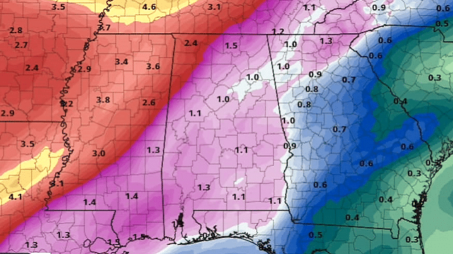
RAIN: The heaviest rain over Alabama will come over the northwest corner of the state; National Weather Service Huntsville has issued a flash flood watch tonight and tomorrow for Lauderdale, Colbert and Franklin counties, where amounts of 2-3 inches are likely. The total for the rest of the state should be around 1 inch with no flooding issues.
FRIDAY AND THE WEEKEND: The sky becomes mostly sunny Friday as dry air returns, and Saturday will be a delightful day with ample sunshine and a high in the mid 70s. Then, on Easter, we are forecasting a partly sunny sky with a high in the low to mid 70s. We will introduce the risk of a few isolated showers near the Tennessee border with a weak front, but most of the state will remain dry Sunday.
NEXT WEEK: It seems like the best chance of showers Monday and Tuesday will remain over far north Alabama and into Tennessee, but the chance of showers, and possibly thunderstorms, will increase statewide over the latter half of the week.

BEACH FORECAST: Click here to see the AlabamaWx Beach Forecast Center page.
WEATHER BRAINS: You can listen to our weekly 90-minute netcast any time on the web or on iTunes. This is the show all about weather featuring many familiar voices, including meteorologists at ABC 33/40.
CONNECT: You can find me on all of the major social networks:
Facebook
Twitter
Google Plus
Instagram
Pinterest
Snapchat: spannwx
For more weather news and information from James Spann and his team, visit AlabamaWx.