James Spann: Strong storms possible in Alabama Friday night
PLEASANT AFTERNOON: After a frosty start, temperatures are mostly in the 60s across Alabama this afternoon with lots of sunshine through a thin later of high cirrus clouds. Tonight will be mostly fair and not as cold as last night; most places will see a low in the 40s early tomorrow morning.
Clouds will increase tomorrow, but most of the day should be dry with just an outside risk of an afternoon shower. The high tomorrow will be in the 72- to 75-degree range, close to seasonal averages.
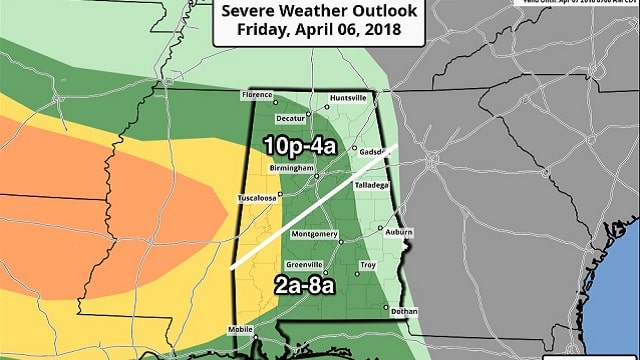
STRONG STORMS TOMORROW NIGHT: The Storm Prediction Center has pushed the severe weather risk into Alabama for tomorrow night. We have a slight risk for areas west of a line from Fayette to Tuscaloosa to Thomaston to Citronelle. A marginal risk extends as far east as Decatur, Talladega, Troy and Dothan.

The primary limiting factor will be low instability values over the northern half of the state; higher CAPE values will be over south Alabama during the pre-dawn hours Saturday. A line of strong storms with gusty winds will push through the state tomorrow night; the main window for north and central Alabama will come from 10 p.m. through 4 a.m. The main threat will come from strong straight-line winds, although a brief isolated tornado can’t be ruled out.
Rain amounts should be around one-half inch, with isolated heavier amounts. No flooding is expected, and the rain will end for the northern half of the state by 6 a.m.
WINTER-LIKE DAY SATURDAY: While it looks like the rain will end very early in the day, Saturday will be mostly cloudy, windy, cold and raw. A touch of drizzle is possible at times, and temperatures will fall through the 50s during the morning, possibly reaching the 40s over north Alabama by afternoon.
FOOTBALL WEATHER: Auburn’s spring A-Day game is Saturday at Jordan Hare Stadium (3 p.m. kickoff). The weather will be cloudy, breezy and fairly cold for April with temperatures falling from the 50s during the first half into the upper 40s by the final quarter.
ANOTHER FREEZE THREAT: The sky will clear Saturday night, and yet another late-season freeze is possible early Sunday morning with most places dropping into the low 30s. Colder pockets could reach the 20s, and frost is likely. Then, we warm into the 60s Sunday afternoon with a good supply of sunshine. Clouds will increase Sunday night, but models continue to trend drier with this impulse and it looks like any rain late Sunday night will be very light and spotty.
NEXT WEEK: The sky will feature more clouds than sun Monday, and a few widely scattered showers are possible with a high in the low 70s. Then, another shot of cooler air rolls into the state Tuesday, and by Wednesday morning we drop into the 30s with a chance of frost. On the positive side, there’s a decent chance this will be the last widespread frost threat of the season.

BEACH FORECAST: Click here to see the AlabamaWx Beach Forecast Center page.
WEATHER BRAINS: You can listen to our weekly 90-minute netcast any time on the web or on iTunes. This is the show all about weather featuring many familiar voices, including meteorologists at ABC 33/40.
CONNECT: You can find me on all of the major social networks:
Facebook
Twitter
Google Plus
Instagram
Pinterest
Snapchat: spannwx
For more weather news and information from James Spann and his team, visit AlabamaWx.


