James Spann: One more dry day for Alabama before storms arrive
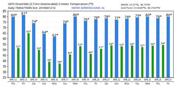
SEVERE CLEAR: With sunshine in full supply, temperatures are mostly in the 78- to 82-degree range across Alabama this afternoon. Tomorrow will be another dry day; expect a partly sunny sky with a gusty south wind of 12-22 mph. Temperatures reach the low 80s. While we enjoy another nice day, we will be watching severe storms that are expected to form from east Texas and Louisiana north into the U.S. Corn Belt. It looks like an active severe weather day there.
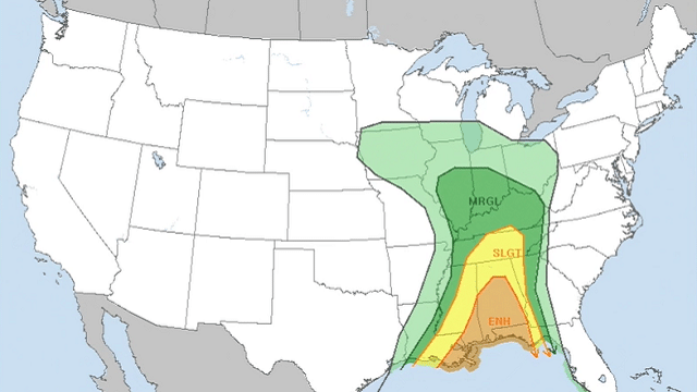
THE ALABAMA WEEKEND SITUATION: After a review of new model data, there isn’t much change in our thinking. A band of showers and weakening thunderstorms will push into west Alabama Saturday morning. These showers will slowly fade as they move eastward. By afternoon more intense thunderstorms will form to the west over eastern Mississippi in response to strong dynamic forcing, and those will move through our state late Saturday afternoon and Saturday night. The Storm Prediction Center has defined an enhanced risk from the Birmingham metro area south to the Gulf Coast. There is a slight risk northward into Tennessee.
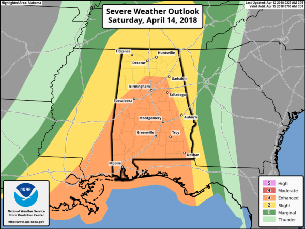
TIMING: It still looks like the main window for heavier storms, possibly severe, will come from 3 Saturday afternoon until 3 a.m. Sunday. There is clearly a chance of rain Saturday morning, especially over west Alabama, but for now severe storms are not expected then.
PLACEMENT: The highest instability values will be over the southern half of Alabama during that 12-hour window, but a few severe storms are possible over north Alabama as well.
THREATS: It seems like the main issue will come from strong straight-line winds, but some hail and an isolated tornado or two are not out of the question.
RAIN: Rain amounts of 2 to 3 inches are likely, with isolated heavier amounts. Some localized flooding is possible.
There is still some uncertainty in how this whole event evolves over the weekend, so watch for forecast changes. These kind of systems are very common here in April in Alabama; this is nothing really unusual or unprecedented.
Rain will end early Sunday; the day will be mostly cloudy, breezy and colder, with temperatures falling into the 50s.
NEXT WEEK: Most of the week looks dry, and Monday and Tuesday morning will be cold, with potential for lows in the 30s. The coldest morning and the greatest threat of frost will come early Tuesday with a clear sky and light wind; some of the normally colder spots around here could see a light freeze. But that should be the last one of the season. We will enjoy a nice warming trend over the latter half of the week.
BEACH FORECAST: Click here to see the AlabamaWx Beach Forecast Center page.
WEATHER BRAINS: You can listen to our weekly 90-minute netcast any time on the web, or on iTunes. This is the show all about weather featuring many familiar voices, including meteorologists at ABC 33/40.
CONNECT: You can find me on all of the major social networks:
Facebook
Twitter
Google Plus
Instagram
Pinterest
Snapchat: spannwx
For more weather news and information from James Spann and his team, visit AlabamaWx.


