James Spann: Cool night ahead in Alabama
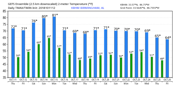
FALL WEATHER IS HERE: Tonight will be the coolest night so far this season for Alabama; we project a low in the mid to upper 40s for most communities across the northern half of the state. The last time Birmingham had a low in the 40s was April 30, when the low was 42.
FRIDAY THROUGH THE WEEKEND: Dry weather continues with sunshine in full supply Friday, and a partly sunny sky Saturday and Sunday. The high will be in the low 70s Friday, followed by mid 70s Saturday and upper 70s Sunday.
FOOTBALL WEATHER: For the high school games Friday night, the weather will be clear and cool, with temperatures falling from the mid 60s at kickoff into the upper 50s by the final whistle.
Saturday, Auburn hosts Tennessee at Jordan-Hare Stadium (11 a.m. kickoff). The sky will be mostly sunny with temperatures rising from near 70 at kickoff into the mid 70s by the fourth quarter.
Alabama will host Missouri Saturday evening (6 p.m. kickoff) at Bryant-Denny Stadium; expect a clear sky with temperatures falling from 74 at kickoff into the upper 60s by the end of the game.
UAB will travel to Houston to play Rice Saturday (noon kickoff). The sky will be partly sunny with a temperature of 82 at kickoff, rising into the mid 80s by the second half.
RACE WEEKEND: It will be a great weekend for NASCAR fans coming into Talladega, with lots of sunshine each day through Sunday and pleasant temperatures. Look for a high in the low 70s Friday, mid 70s Saturday and upper 70s Sunday. Mornings will be cool, with lows in the 40s and 50s.
NATIONAL SHRIMP FESTIVAL: Expect sunny days and fair nights at Gulf Shores through Sunday with highs around 80 and lows in the upper 50s and low 60s. Could not be any better.
NEXT WEEK: We will bring in a chance of showers early next week, especially on Tuesday, with a disturbance approaching from the west. Then, another surge of cool, dry air rolls in Wednesday.
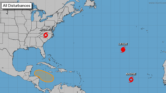
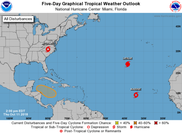
TROPICS: Hurricane Leslie and Tropical Storm Nadine will remain in the far eastern Atlantic, no threat to land. Michael, a tropical storm now, will move back into the Atlantic late tonight as it accelerates to the northeast. A broad low over the Caribbean has a 40 percent chance of development over the next five days, but it looks like it will move into either Central America or Mexico; any threat to the Gulf of Mexico looks low for now.
 BEACH FORECAST: Click here to see the AlabamaWx Beach Forecast Center page.
WEATHER BRAINS: You can listen to our weekly 90-minute show any time on your favorite podcast app. This is the show all about weather featuring many familiar voices, including meteorologists at ABC 33/40.
CONNECT: You can find me on all of the major social networks:
Facebook
Twitter
Instagram
Pinterest
Snapchat: spannwx
For more weather news and information from James Spann and his team, visit AlabamaWx.


