James Spann: Quiet day for Alabama before soaking rain begins Tuesday
James Spann has the Alabama forecast for Presidents Day and a rainy week ahead from Alabama NewsCenter on Vimeo.
ON THE MAPS: A surface front is over south Alabama this morning; north of that front temperatures are in the 37- to 45-degree range, but south of the front Dothan reported 60 degrees just before daybreak. For north and central Alabama, today will be mostly cloudy and cool, with temperatures holding in the 40s north of Birmingham and 50s south of I-20. The sun could break out a bit this afternoon, and the day should be dry. Showers will be confined to the far southern counties of the state.
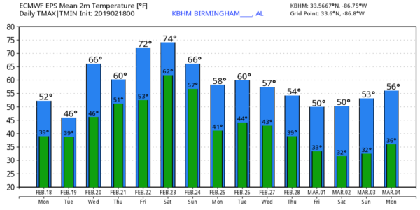
LONG-TERM SOAKER AHEAD: Rain becomes widespread across Alabama Tuesday as the front over south Alabama begins to creep northward as a warm front. The day will still be very cool over the northern half of the state, with a high only in the low 50s. Communities south of Montgomery will see a high in the 60s.
The warm front will move to near the Tennessee state line late Tuesday night, so Wednesday will be warmer, with a high in the 60s. Occasional rain and a few thunderstorms will continue; there is a marginal risk (level 1 out of 5) of severe storms over parts of southwest Alabama Wednesday, but the overall threat level is fairly low. The persistent rain is the big issue.
The weather stays wet Thursday and Friday with occasional rain. The front will continue to oscillate over north Alabama; Thursday will be cooler with a high around 60, but we rise to near 70 degrees Friday.
For those planning outdoor events, there is no way to give you specific rain start/stop times this week; it could rain at any hour of the day or night Tuesday through Friday.
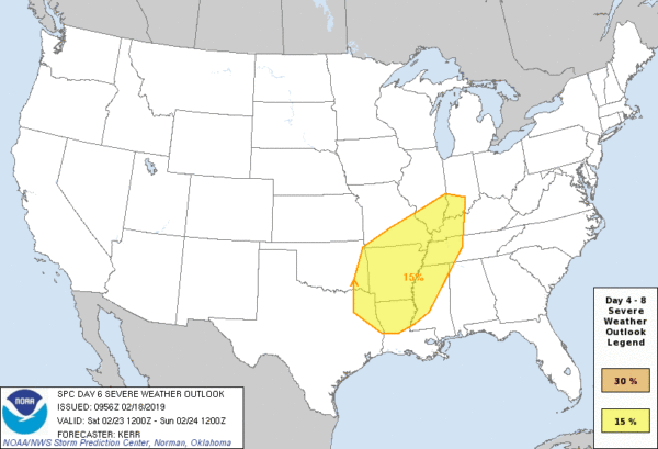
SEVERE STORMS THIS WEEKEND? A deep surface low will form west of Alabama Saturday as the big upper trough over the western U.S. finally begins to move. This should push the warm front north of the state, and we actually could be dry a decent part of the day Saturday (although we will still mention a chance of showers in the forecast). Temperatures will warm into the 70s, making the air unstable, and with the approach of a cold front we will have a chance of strong to severe storms at some point late Saturday, Saturday night and early Sunday morning. The Storm Prediction Center has already defined a severe weather threat for a large area just north and west of here Saturday. It is too early to know the magnitude of the threat in Alabama — just something to watch for now.
Dry air finally returns to the state Sunday afternoon.
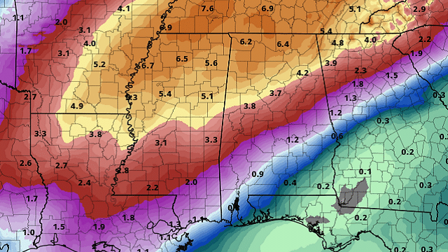
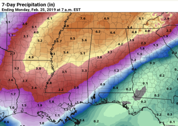
FLOODING POTENTIAL: Much of north Alabama received more than 1 inch of rain yesterday; additional rain amounts of 3-7 inches are likely along and north of I-20 between now and Sunday morning. This could bring the threat of some flash flooding, along with potential for longer-term river flooding. People in flood-prone areas and those who live along creeks, streams and rivers need to pay attention to the weather situation in coming days.
Rain amounts over south Alabama will be much lighter.
NEXT WEEK: The weather should be much drier for Alabama and the Deep South, at least for the first half of next week.
ON THIS DATE IN 1992: A thunderstorm spawned an unusually strong EF-4 tornado for so far north and the time of the year in southern Van Wert County in Ohio. The tornado touched down just west of U.S. Route 127 and traveled northeastward for about 3 miles.
BEACH FORECAST: Click here to see the AlabamaWx Beach Forecast Center page.
WEATHER BRAINS: You can listen to our weekly 90-minute show any time on your favorite podcast app. This is the show all about weather featuring many familiar voices, including meteorologists at ABC 33/40.
CONNECT: You can find me on all of the major social networks:
Facebook
Twitter
Instagram
Pinterest
Snapchat: spannwx
For more weather news and information from James Spann and his team, visit AlabamaWx.