James Spann: Tranquil weather pattern continues for Alabama
James Spann has the Alabama forecast for Monday and a look at the week ahead from Alabama NewsCenter on Vimeo.
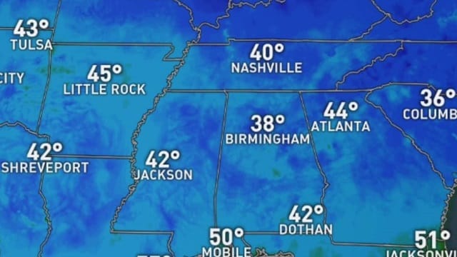
CHILLY MORNINGS, PLEASANT AFTERNOONS: We are starting off the day with temperatures in the 30s in most places across north and central Alabama, with a few spots below freezing:
- Fort Payne — 31
- Pell City — 32
- Gadsden — 34
- Anniston — 34
- Talladega — 34
- Sylacauga — 36
- Demopolis — 36
- Birmingham — 37
- Tuscaloosa — 40
- Montgomery — 44
- Mobile — 48
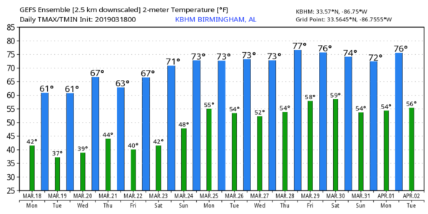
Today will be sunny with a high in the low 60s. Tonight will be clear and a bit colder; we project a low early tomorrow in the 28- to 34-degree range with frost likely. Then, tomorrow will be another sunny, cool day with a high not too far from 60 degrees.
WEDNESDAY THROUGH FRIDAY: The sky will stay sunny Wednesday with a high in the mid to upper 60s. Clouds will increase Wednesday night, and a passing disturbance could squeeze out a few sprinkles or patches of light rain over northwest Alabama late Wednesday night or Thursday morning. Moisture will be very limited, and rain amounts, if any, will be very light. The day Thursday will be generally cloudy with a high in the low 60s. Then, on Friday, sunshine returns in full force with a high in the upper 60s.
THE ALABAMA WEEKEND: Saturday will be sunny and warmer with a high in the mid 70s. Then, on Sunday, clouds move in, and rain is possible late Sunday afternoon and Sunday night. The weather stays mild Sunday with a high in the 70s.
NEXT WEEK: Rain will end Monday morning, but another disturbance could bring showers on Tuesday and Tuesday night. The latter half of the week looks dry, and highs through the week should be in the 70s.
STORM SURVEYS: National Weather Service survey teams have identified a total of 15 tornadoes from the severe storms that moved over the state last Thursday. Thankfully there were no fatalities and no serious injuries. All of them were rated EF-0 or EF-1, with the exception of one EF-2 tornado in Elmore County near the western shore of Lake Jordan.
LAST FREEZE? Many north and central Alabama communities will see a freeze early tomorrow morning. After that, there’s no sign of any freezing temperatures for the rest of March. But, fair warning, we almost always have a cold snap in early April. For many, I doubt that tomorrow will be the last freeze of the season.
ON THIS DATE IN 1925: The great “Tri-State Tornado” occurred, the deadliest tornado in U.S. history. The storm claimed 695 lives (including 234 at Murphysboro, Illinois, and 148 at West Frankfort, Illinois) and caused $17 million property damage. It cut a swath of destruction 219 miles long and as much as a mile wide from east-central Missouri to southern Indiana between 1 p.m. and 4 p.m. The tornado leveled a school in West Frankfort, Illinois, and picked up 16 students, setting them down unharmed 150 yards away. Seven other tornadoes claimed an additional 97 lives that day.
NEED HELP WITH YOUR WEATHER RADIO? We will be in Jacksonville tonight programming NOAA Weather Radio receivers. If you need help, come see us. We will be on the fifth floor of Jacksonville State University stadium from 4 until 6 p.m.

BEACH FORECAST: Click here to see the AlabamaWx Beach Forecast Center page.
WEATHER BRAINS: You can listen to our weekly 90-minute show any time on your favorite podcast app. This is the show all about weather featuring many familiar voices, including the meteorologists at ABC 33/40.
CONNECT: You can find me on the major social networks:
Facebook
Twitter
Instagram
Pinterest
Snapchat: spannwx
For more weather news and information from James Spann and his team, visit AlabamaWx.


