James Spann: Afternoon storms could produce hail in Alabama
James Spann forecasts a stormy start for the Alabama work week from Alabama NewsCenter on Vimeo.
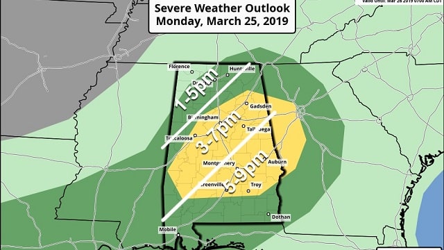
ACTIVE DAY AHEAD: Rain is falling over northwest Alabama early this morning; this will move slowly eastward and dissipate in coming hours. Then, as a short-wave upper trough approaches, new showers and thunderstorms will form this afternoon. The Storm Prediction Center has defined a slight risk (level 2 out of 5) of severe storms for much of central Alabama, including places like Birmingham, Tuscaloosa, Anniston, Gadsden, Clanton, Demopolis, Greenville and Opelika. A marginal risk (level 1 of 5) covers most of the rest of the state.
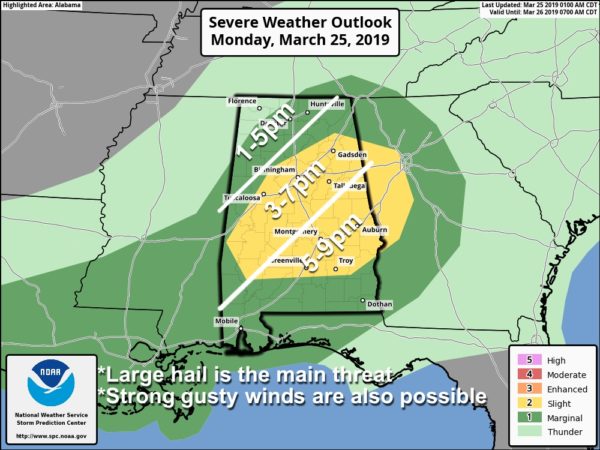
TIMING: The main window for strong to severe storms will come from 1 until 7 p.m.
THREATS: The main issue will be large hail. Thunderstorms will be capable of producing hail up to golf-ball size. You might want to do your best to not have your vehicle outside later today when the storms move through. Strong, gusty winds are also possible. The tornado threat is very low.
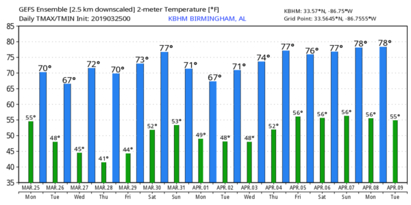
Temperatures will rise to near 70 degrees this afternoon, and the storms will end from northwest to southeast this evening.
REST OF THE WEEK: Tomorrow will be partly sunny and cooler, with a high in the low 60s. The coldest morning of the week will come early Wednesday, when temperatures will drop into the 36- to 42-degree range. Colder valleys could see a light freeze and frost. Then, with a sunny sky, we warm to near 70 degrees Wednesday afternoon. Thursday and Friday will be mild and dry, with ample sunshine and highs in the mid 70s.
THE ALABAMA WEEKEND: A cold front will pass through the state, bringing the next chance of rain. For now it looks like the main window for rain will come from late Saturday afternoon through Saturday night and into early Sunday morning. At the moment the severe weather risk looks low, and rain amounts should be one-half inch or less. The high Saturday will be in the mid 70s, but Sunday will be cooler, with a high between 55 and 60 degrees.
SPOTTER TRAINING: Our annual storm spotter training is Thursday, March 28, at the Pelham Civic Complex. Doors open at 5 and training begins at 6:30. There’s no fee and no need to register. Just show up with a curious mind. You will help us make the severe weather warning process more efficient, and you will never look at a storm the same again. Hope to see you there.
ON THIS DATE IN 1901: More than 20 people were killed by an estimated EF-3 tornado that moved across parts of Birmingham. The twister cut a 15-mile path from the south side of the city to Avondale and Irondale.
BEACH FORECAST: Click here to see the AlabamaWx Beach Forecast Center page.
WEATHER BRAINS: You can listen to our weekly 90-minute show any time on your favorite podcast app. This is the show all about weather featuring many familiar voices, including the meteorologists at ABC 33/40.
CONNECT: You can find me on the major social networks:
Facebook
Twitter
Instagram
Pinterest
Snapchat: spannwx
For more weather news and information from James Spann and his team, visit AlabamaWx.


