James Spann: Another scorcher for Alabama; strong storms possible tonight
James Spann forecasts torrid Tuesday temps for Alabama from Alabama NewsCenter on Vimeo.
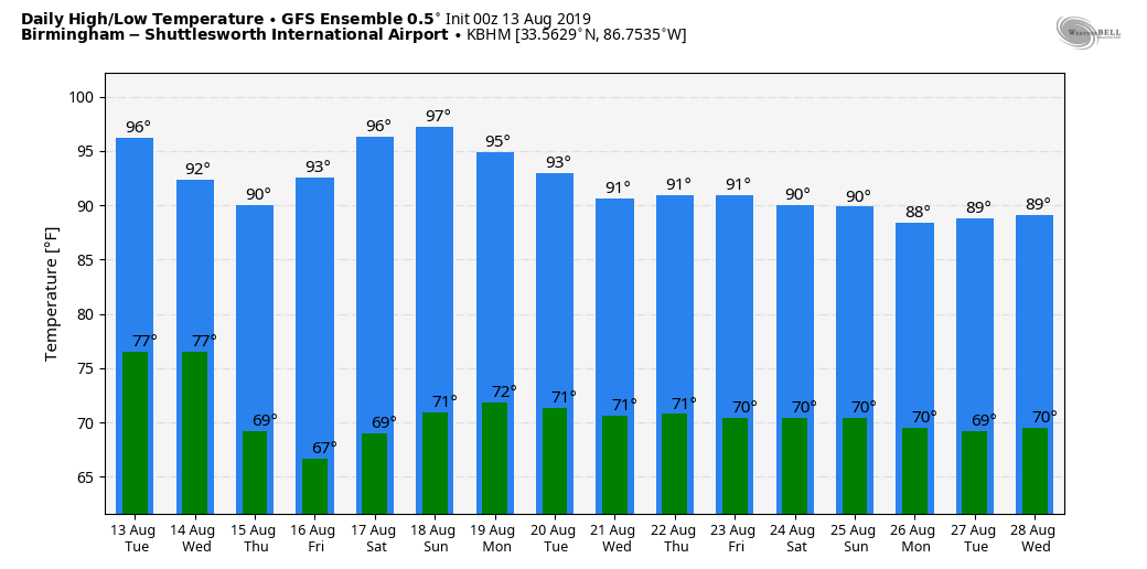
ANOTHER HOT AUGUST DAY AHEAD: Alabama’s weather won’t change much today; the sky will be partly to mostly sunny, and most communities will see a high in the upper 90s this afternoon. The National Weather Service continues an excessive heat warning for west Alabama, with a heat advisory for the rest of the state because of the high heat index values expected. A few afternoon showers are possible, but they should be few and far between.
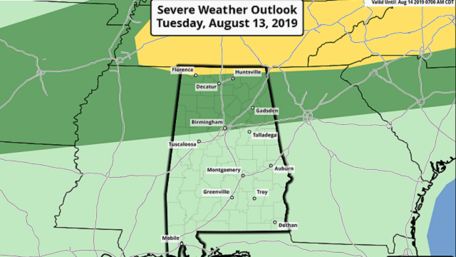
TONIGHT: An approaching surface front will push a band of showers and thunderstorms into north Alabama. Initially they could be strong, mainly over the Tennessee Valley. The Storm Prediction Center has defined a slight risk (level 2 out of 5) of severe storms near the Tennessee state line and a marginal risk (level 1 of 5) as far south as Birmingham.
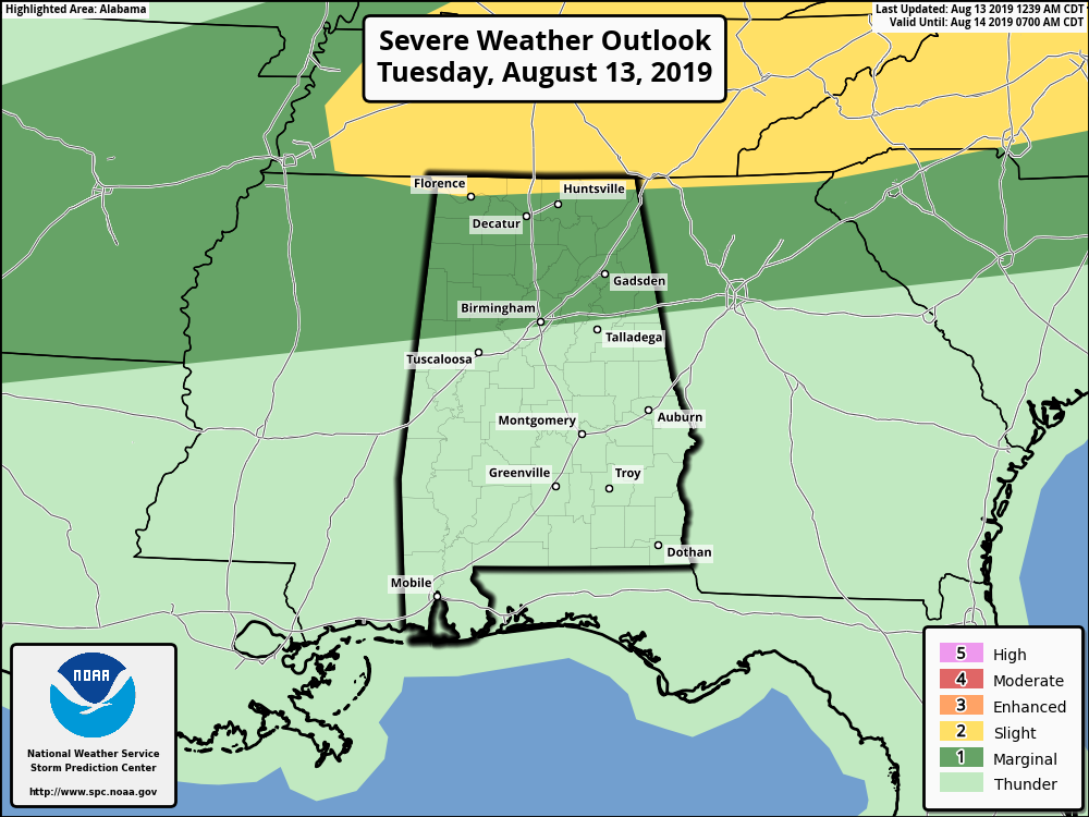
The main threat with the heavier storms will come from strong straight-line winds. Thunderstorms will weaken as they move deeper in Alabama, and they will probably fizzle out about the time they reach I-20 around midnight.
WEDNESDAY: The front will continue to push slowly southward, and the best chance of showers and storms will shift down into south Alabama. They will mostly come during the afternoon and evening. The SPC has a marginal risk defined for about the southern half of the state as a few strong storms are certainly possible. Drier air, however, moves into north Alabama, and the day should be mostly sunny. The heat backs off with highs in the low 90s, and humidity levels will be lower as well.
THURSDAY THROUGH THE WEEKEND: The weather is looking dry with mostly sunny days and fair nights. Highs will be mostly in the low 90s and nighttime temperatures a bit cooler, with early morning lows in the 60s.
NEXT WEEK: Dry weather will most likely continue Monday, but scattered showers and storms will return to the forecast Tuesday through Friday as moisture levels rise. Highs during the week will hold mostly in the low 90s, right at seasonal levels for August in Alabama.
TROPICS: No tropical storm formation is expected in the Atlantic basin through early next week.
HEAT PARADE: Here are some highs reported across Alabama yesterday:
- Coker — 100
- Calera (Shelby County Airport) — 100
- Jacksonville — 100
- Birmingham Airport — 99
- Bessemer — 99
- Remlap — 99
- Concord — 99
- Montgomery — 99
- Northport — 98
- Arley — 98
- Alabaster — 98
- Tuscaloosa — 97
- Rainbow City — 97
- Mobile — 93
ON THIS DATE IN 1987: A succession of thunderstorms produced rainfall that was unprecedented in 116 years of precipitation records at Chicago during an 18-hour period from the evening of Aug. 13 to the early afternoon of Aug. 14. The resulting flash flood was the worst ever to strike the Chicago metropolitan area, causing three deaths and water damage that amounted to $221 million. O’Hare International Airport received an event total of 9.35 inches of rain in 18 hours, shattering the previous 24-hour record of 6.24 inches. For about 24 hours, the airport was accessible only from the air as all roads were blocked by high water, including the Kennedy Expressway.
BEACH FORECAST: Click here to see the AlabamaWx Beach Forecast Center page.
WEATHER BRAINS: You can listen to our weekly 90-minute show any time on your favorite podcast app. This is the show all about weather featuring many familiar voices, including the meteorologists at ABC 33/40.
CONNECT: You can find me on the major social networks:
Facebook
Twitter
Instagram
Pinterest
Snapchat: spannwx
For more weather news and information from James Spann and his team, visit AlabamaWx.


