James Spann: Heat levels drop today, with storms for south Alabama
James Spann has good news for Alabama in the midweek forecast from Alabama NewsCenter on Vimeo.
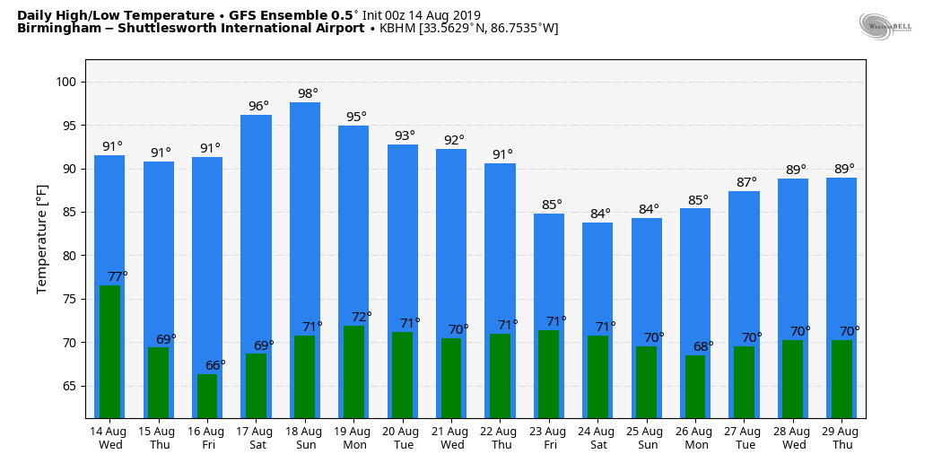
NOT AS HOT: Every day in August in Alabama is hot. Today will be hot, but not nearly as hot as recent days thanks to a surface front that moved through overnight. The high today will be in the low 90s over north and central Alabama, about 10 degrees “cooler” than yesterday.
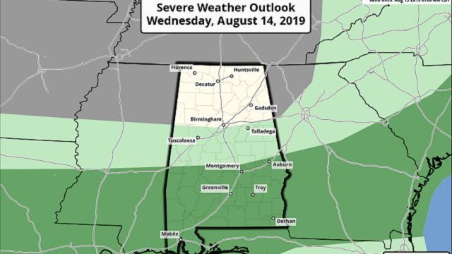
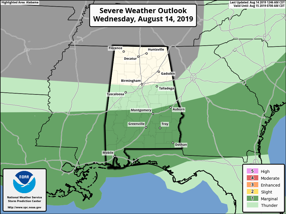
This morning the front is over the middle of the state and moving slowly southward. Additional showers and storms will form over south Alabama this afternoon, and the Storm Prediction Center maintains a marginal risk (level 1 out of 5) of severe thunderstorms there. Some of the heavier storms will produce strong straight-line winds.
Showers should be almost impossible to find over the northern half of the state today as dry air continues to move southward.
THURSDAY THROUGH THE WEEKEND: Thursday, Friday and Saturday will be dry with mostly sunny days, lower humidity levels and slightly cooler nights. Highs will be mostly in the low 90s Thursday and Friday, with lows generally in the upper 60s. Heat levels will tick up a bit over the weekend, with mid 90s a good possibility. We will introduce the chance of a few isolated afternoon showers Sunday as moisture levels begin to increase.
NEXT WEEK: We will have the chance of scattered, mostly afternoon and evening showers and thunderstorms each day next week as a weak upper trough hangs around the region. Otherwise, look for partly sunny days with highs between 88 and 92 on most days.
TROPICS: All remains very quiet across the Atlantic basin, and tropical storm formation is not expected through early next week.
TUESDAY’S HEAT: These are official highs for Tuesday across Alabama (not from car thermometers, phone apps or consumer thermometers — actual properly measured air temperatures):
- Marion — 103
- Sylacauga — 102
- Calera — 102
- Birmingham — 101
- Anniston — 101
- Bessemer — 101
- Montgomery — 101
- Demopolis — 100
- Pell City — 100
- Gadsden — 100
- Cullman — 99
- Mobile — 98
- Huntsville — 97
- Alexander City — 96
- Auburn — 93
ON THIS DATE IN 1969: Hurricane Camille, a powerful, deadly and destructive hurricane formed just west of the Cayman Islands. It rapidly intensified, and by the time it reached western Cuba the next day, it was a Category 3 hurricane. Camille was spawned Aug. 5 by a tropical wave off the coast of Africa. The storm became a tropical disturbance Aug. 9 and a tropical storm Aug. 14 with a 999-millibar pressure center and 55 mph surface winds. Landfall would come Aug. 17 on the Mississippi coast as a category five hurricane.
BEACH FORECAST: Click here to see the AlabamaWx Beach Forecast Center page.
WEATHER BRAINS: You can listen to our weekly 90-minute show any time on your favorite podcast app. This is the show all about weather featuring many familiar voices, including the meteorologists at ABC 33/40.
CONNECT: You can find me on the major social networks:
Facebook
Twitter
Instagram
Pinterest
Snapchat: spannwx
For more weather news and information from James Spann and his team, visit AlabamaWx.


