James Spann: Big pattern change coming for Alabama, but today will be hot
James Spann forecasts a still-scorching end to the Alabama work week from Alabama NewsCenter on Vimeo.
BIG CHANGES COMING: No doubt summer has overstayed its welcome, as many places across Alabama hit triple digits Thursday. Heat levels today will be down about five degrees, but still most places reach the mid 90s with a good supply of sunshine. Isolated showers and storms could fire up again this afternoon, but they will be mostly over the southern half of the state.
On Saturday, a backdoor-type cold front will move in from the east and bring a chance of showers to the state. They are most likely over the eastern half of the state, and most communities east of I-65 will see a high in the mid to upper 80s. But to the west, highs will be in the low 90s for places like Fayette, Tuscaloosa and Demopolis.
Sunday the upper high begins to break down, and we will mention a chance of showers statewide with temperatures remaining below 90 degrees. There is a good chance we won’t see 90s again until next summer.
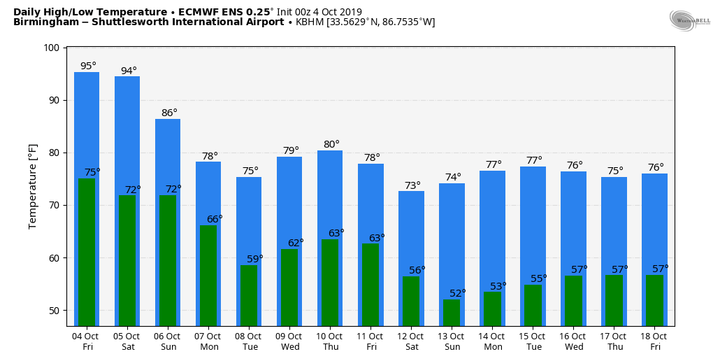
NEXT WEEK: The long-awaited cold front pushes into Alabama Monday with clouds and periods of rain; most communities hold in the 70s. Dry and very pleasant weather is likely Tuesday and Wednesday, with highs between 75 and 80 and lows mostly in the 50s. Some rain is possible late in the week with another cold front approaching.
FOOTBALL WEATHER: For the high school games tonight, the sky will be mostly fair with temperatures falling from the low 80s at kickoff into the upper 70s by the final whistle.
Saturday, Auburn travels to Gainesville to take on the Florida Gators (2:30 p.m. Central kickoff). The sky will be partly to mostly sunny with a kickoff temperature in the low 90s and just a 1-in-5 chance of a brief passing shower during the game.
Saturday evening UAB will host Rice at Birmingham’s Legion Field (kickoff at 6). There will be just an outside risk of a shower early in the game; otherwise it will be mostly fair with temperatures falling from near 88 at kickoff through the 80s during the game.
Jacksonville State will host Tennessee State Saturday evening (kickoff at 6). There will be a risk of showers, mainly during the first half of the game. Temperatures fall from near 85 at kickoff into the upper 70s by the fourth quarter.
TROPICS: A weak tropical wave near the Yucatan Channel is not expected to develop; otherwise the Atlantic basin is very quiet this afternoon. Tropical storm formation is not expected over the next five days.
RECORDS KEEP FALLING: Here are some official highs around Alabama Thursday:
- Montgomery — 102
- Birmingham — 101
- Tuscaloosa — 101
- Anniston — 100
- Pell City — 100
- Selma — 100
- Demopolis — 100
- Huntsville — 100
- Muscle Shoals — 100
- Cullman — 98
- Mobile — 98
Tuscaloosa’s temperature dropped 22 degrees in 15 minutes thanks to a passing thunderstorm; it dropped 0.4 inches of rain at the Tuscaloosa Airport.
ON THIS DATE IN 2005: Hurricane Stan, a minimal Category 1 hurricane with 75 mph maximum sustained surface winds, made landfall near Punta Roca Partida, Mexico, at 4 a.m. EDT. While it was not a particularly strong hurricane, the torrential rains caused flooding and landslides, resulting in 1,513 deaths in Guatemala.
BEACH FORECAST: Click here to see the AlabamaWx Beach Forecast Center page.
WEATHER BRAINS: You can listen to our weekly 90-minute show any time on your favorite podcast app. This is the show all about weather featuring many familiar voices, including the meteorologists at ABC 33/40.
CONNECT: You can find me on the major social networks:
Facebook
Twitter
Instagram
Pinterest
Snapchat: spannwx
For more weather news and information from James Spann and his team, visit AlabamaWx.


