James Spann: One more dry day for Alabama before rain returns
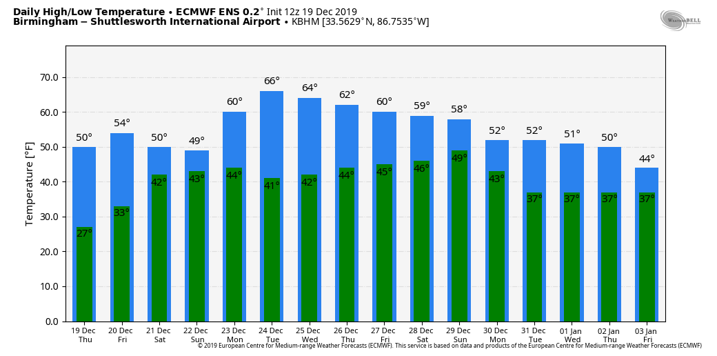
SUNNY, COOL DECEMBER DAY: Once again today we have sunshine in full force across Alabama, and temperatures remain below average with 40s and 50s across the state. Tonight will be clear and cold again; most places will see a low in the 25- to 30- degree range early Friday. Then, during the day, the weather stays dry with a partly sunny sky. The high Friday afternoon will be in the 54- to 58-degree range. Clouds thicken Friday night.
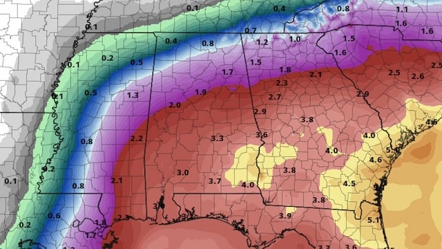
RAIN RETURNS OVER THE WEEKEND: Saturday will be a cloudy day, and rain will spread northward quickly statewide as a low-pressure area moves out of the Gulf of Mexico. Rain becomes widespread Saturday afternoon, Saturday night and into a decent part of the day Sunday. The air will be cool and stable with highs in the 50s, so no severe storms this time and probably not much thunder. The heaviest rain will fall over south Alabama, where amounts of 2-4 inches are likely. Totals over north and central Alabama will be in the 1- to 2-inch range, with lighter amounts to the north over the Tennessee Valley.
CHRISTMAS WEEK: The week looks dry and uneventful, with mostly sunny, mild days and clear, chilly nights. Highs will be mostly in the 60s, lows in the 30s and 40s. Moisture will increase on Friday, but new global model data suggests the next rain will hold off until sometime over the weekend of Dec. 28-29.
RAIN UPDATE: Here are rain totals since Jan. 1, and the departure from average:
- Mobile — 61.61 inches (deficiency of 2.35 inches)
- Tuscaloosa — 58.47 ( surplus of 7.59)
- Huntsville — 56.2 (surplus of 4.12)
- Anniston — 51.57 (surplus of 3.49)
- Birmingham — 49.89 (deficiency of 2.12)
- Montgomery — 45.14 (deficiency of 5.97)
ON THIS DATE IN 2009: Snowfall totals from 1 to 2 feet were commonplace in what will go down as one of the biggest snowstorms in history on the East Coast and the first of four snowstorms for the Mid-Atlantic during the winter of 2009-10. The 15 inches of snow measured at Reagan International Airport on Dec. 19 was the third-highest daily snowfall on any calendar day at Washington, D.C., since snowfall records began in 1884. The total storm snowfall of 16.4 inches on Dec 18-19, 2009, marks the sixth-highest two-day snowfall record for Washington, putting it just below the second President’s Day storm in 2003 and ahead of the January 1996 storm. Baltimore Washington Airport saw 20.5 inches of snow, which went down as the fifth-highest daily snowfall on any calendar day in Baltimore since snowfall records began in 1893.
BEACH FORECAST: Click here to see the AlabamaWx Beach Forecast Center page.
WEATHER BRAINS: You can listen to our weekly 90-minute show any time on your favorite podcast app. This is the show all about weather featuring many familiar voices, including the meteorologists at ABC 33/40.
CONNECT: You can find me on the major social networks:
Facebook
Twitter
Instagram
Pinterest
Snapchat: spannwx
For more weather news and information from James Spann and his team, visit AlabamaWx.


