James Spann: Severe storms likely across Alabama Saturday
James Spann has the Alabama forecast and a look at Saturday’s severe weather from Alabama NewsCenter on Vimeo.
MILD, BREEZY TODAY: The sky will be mostly cloudy across Alabama through tonight with a south wind averaging 10-20 mph. A few showers are possible by afternoon, but a decent part of the day should be dry. To the west, a very active severe weather day is likely for parts of Texas, Oklahoma, Arkansas and Louisiana.
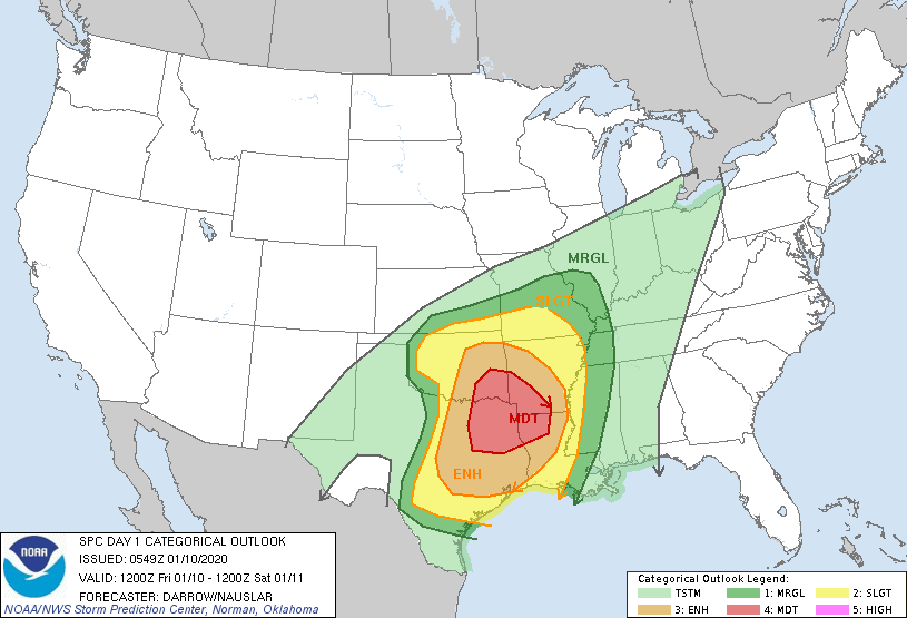
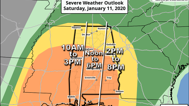
ALABAMA SEVERE WEATHER THREAT SATURDAY: All of Alabama has a risk of severe thunderstorms during the day Saturday. The Storm Prediction Center has defined an enhanced risk (level 3 of 5) for areas south of a line from Vernon to Birmingham to Opelika, with a slight risk (level 2 of 5) up to the Tennessee state line.
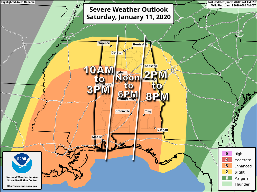
TIMING: While storms could enter far west Alabama as early as 10 a.m., it looks like the core threat will come from noon to 7 p.m. This will be generally a daytime event.
THREATS: Storms across Alabama will be capable of producing damaging straight-line winds and a few tornadoes. A strong tornado (EF-2 or higher) can’t be ruled out.
IMPORTANT NOTE CONCERNING WARNINGS: A long squall line will move across Alabama. The low-level jet (5,000 feet off the ground) is forecast to be in the 50- to 80-knot range, and it won’t take much to get some of that transferred down to the surface with these thunderstorms. The line will be capable of producing widespread wind damage, and I would suggest going through your tornado safety action plan if you are in a severe thunderstorm warning. Many trees will likely be blown down by this line of severe storms. The bottom line is to take severe thunderstorm warnings seriously Saturday.
GRADIENT WIND: Even away from thunderstorms, Saturday will be very windy. South winds will average 15-30 mph, with gusts to 40 mph. A wind advisory is in effect for most of the state.
RAIN: Amounts of 1 to 2 inches are likely Saturday; thankfully the storms will be moving quickly, which should help to mitigate major flooding.
CALL TO ACTION: Everyone will need a good, reliable way of getting severe weather warnings Saturday if they are needed. Be sure wireless emergency alerts are enabled on your phone, and download the free ABC 33/40 weather app as well. Have a NOAA Weather Radio in your home and business. Never rely on an outdoor siren.
Identify the safe place in your home. In a site-built home, it is a small room on the lowest floor, near the center of the home and away from windows. Be sure everybody in the family knows where that safe place is, and in that room you need helmets for everyone in your family. We also recommend having a portable air horn for everyone, as well as hard-soled shoes. If you live in a mobile home, you cannot stay there if you are in a tornado warning polygon. Know the location of the nearest shelter or site-built structure that is available. On Saturday, I would recommend not being in a mobile home if you are under a severe thunderstorm warning.
We walk a fine line with events like this; we have to spread the word and clearly outline the danger, but at the same time we don’t want to spread storm anxiety. Just have a way of warnings and have a good plan, and we will get through the day together just fine. You can also help us by spreading the word; many Alabamians have no idea we have a severe weather threat Saturday. Let them know the day will be active, and they must be in a position to hear warnings.
Sunday will be dry with a partly sunny sky and a high in the mid 60s.
NEXT WEEK: Moisture returns Monday with a chance of rain by afternoon, and we will have periods of rain Tuesday and Wednesday. Temperatures will remain mild; in fact, there is a good chance we reach the low to mid 70s Tuesday and Wednesday. A few strong storms are possible at midweek ahead of a cold front; cooler air returns Thursday and Friday, but still no sign of any really cold Arctic air.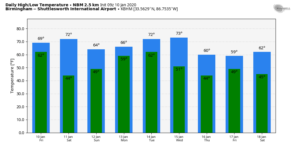
ON THIS DATE IN 1975: At least 13 tornadoes touched down in Alabama, including an EF-3 that moved through St. Clair County. Here is the storm summary of the damage area from Bob Ferry, meteorologist-In-charge of the Birmingham National Weather Service at the time:
“Friday afternoon, January 10, 1975, a tornado moved northeastward across the center of downtown Pell City, Alabama, and stopped the First National Bank clock at 4:11 p.m. Many buildings, mostly homes, were heavily damaged by large trees (some 5 to 6 feet in diameter near the trunk) uprooted and falling across them. Seven mobile homes were completely destroyed in a small trailer park (Smith’s) which is about one mile northeast of Pell City. The Red Cross reported that 33 people were taken to the hospital for treatment, where only three were admitted — those, not too serious. There were no injuries in the trailer park because residents had taken shelter in a nearby brick building. None of the trailers had tie-downs.” Along the path, at least 54 homes were destroyed and 307 were damaged. Fifteen trailers were destroyed and 27 businesses were damaged or destroyed. One person was killed at a service station.
BEACH FORECAST: Click here to see the AlabamaWx Beach Forecast Center page.
WEATHER BRAINS: You can listen to our weekly 90-minute show any time on your favorite podcast app. This is the show all about weather featuring many familiar voices, including the meteorologists at ABC 33/40.
CONNECT: You can find me on the major social networks:
Facebook
Twitter
Instagram
Pinterest
Snapchat: spannwx
For more weather news and information from James Spann and his team, visit AlabamaWx.