James Spann: A little cooler today in Alabama
James Spann has the forecast for a cooling Alabama from Alabama NewsCenter on Vimeo.
COOLER, BRIGHTER TODAY: A cold front is passing through central Alabama early this morning; a band of showers ahead of the front is pushing into the southern part of the state. The National Weather Service continues a dense fog advisory this morning for roughly the southern half of the state; the fog will dissipate by mid-morning for most places.
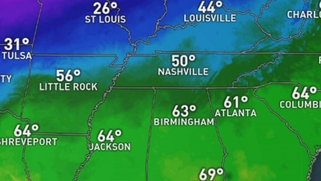
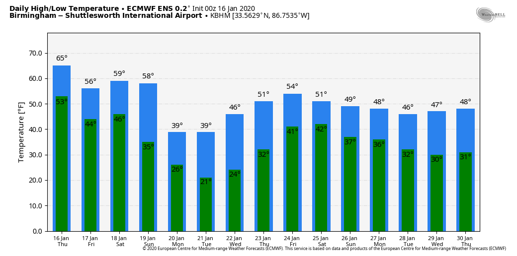
Morning clouds should give way to a partly sunny afternoon, and the high today will be in the 58- to 62-degree range, a little cooler than recent days. Showers this afternoon should be confined to far south Alabama, and temperatures will drop into the mid to upper 30s early Friday morning. During the day Friday, we project a high in the upper 50s with a mostly cloudy sky, although the sun could break out at times. Friday looks mostly dry statewide.
THE ALABAMA WEEKEND: A cold front will bring showers to the state Saturday. We see no severe storms at this time with a stable air mass (highs will be in the 50s), and we aren’t expecting much thunder. Rain amounts Saturday should be less than one-half inch. The best chance of rain comes from about 9 a.m. until 4 p.m. On Sunday the sky becomes sunny, but the day will be breezy and colder, with a high in the mid 40s.
MUCH COLDER NEXT WEEK: We will see the coldest air since mid-November early next week. The highs Monday and Tuesday will be in the 38- to 42-degree range over the northern half of the state, and morning lows will be well below freezing. The coldest morning will come early Tuesday, with temperatures between 17 and 22 early in the day. On the positive side, the air will be very dry and the sky will feature sunshine in full supply. We start to warm up a bit Wednesday afternoon, with a high in the low 50s.
Clouds begin to return Thursday, and rain is likely by Thursday night and Friday with the next storm system coming in from the west. The air will be too warm by then for any ice or snow and too cool for any severe weather problems.
WET START: Birmingham’s rain total so far this year is 5.94 inches, which is 3.73 inches above average. The total since Dec. 1 is 11.03 inches.
ON THIS DATE IN 2018: A winter storm brought 2 to 4 inches of snow to parts of north and central Alabama. The most significant travel impacts were along and either side of the I-85 corridor and along a stretch of I-65 in Chilton and Autauga counties, where ice-covered roadways resulted in road closures and stuck vehicles. Elsewhere, icy roadways were reported as well, though lighter snow totals and blowing of snow from road surfaces helped limit the overall scope of impacts.
BEACH FORECAST: Click here to see the AlabamaWx Beach Forecast Center page.
WEATHER BRAINS: You can listen to our weekly 90-minute show any time on your favorite podcast app. This is the show all about weather featuring many familiar voices, including the meteorologists at ABC 33/40.
CONNECT: You can find me on the major social networks:
Facebook
Twitter
Instagram
Pinterest
Snapchat: spannwx
For more weather news and information from James Spann and his team, visit AlabamaWx.