James Spann: Warming trend begins this afternoon in Alabama
James Spann has the midweek forecast for Alabama from Alabama NewsCenter on Vimeo.
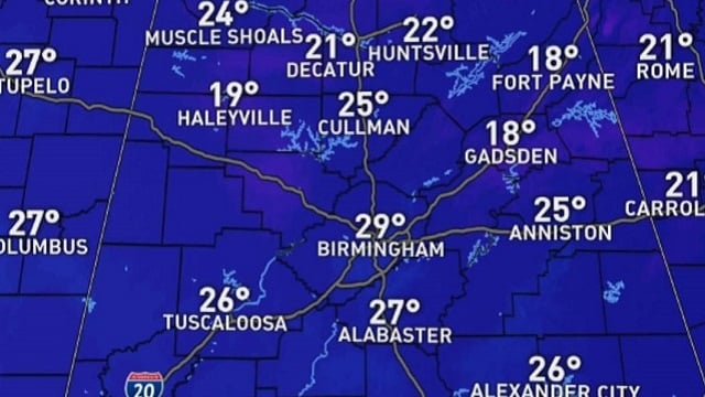
ANOTHER FRIGID MORNING: Here are some temperatures just before daybreak across Alabama:
- Gadsden — 18
- Heflin — 18
- Fort Payne — 18
- Weaver — 19
- Hueytown — 20
- Haleyville — 20
- Millport — 20
- Pell City — 21
- Decatur — 22
- Huntsville — 23
- Sylacauga — 23
- Jemison — 24
- Tuscaloosa — 24
- Anniston — 25
- Muscle Shoals — 25
- Montgomery — 25
- Mobile — 31
The good news is that a warming trend begins this afternoon; temperatures will rise into the low 50s with a partly sunny sky. Clouds will move into the state tonight ahead of the next system to the west.
RAIN RETURNS: Models have trended faster, and it now looks like rain will move into the state Thursday morning. Look for periods of rain Thursday and Thursday night; temperatures will hold in the 40s over north Alabama, so the air will be cool and stable and there is no risk of severe storms, and probably no thunder, although some people across south Alabama might have a thunderstorm. The rain will end from west to east Friday morning; clouds linger Friday afternoon with a high in the mid 50s. Rain amounts will be in the one-half-inch to 1-inch range for much of the state.
THE ALABAMA WEEKEND: The weekend will be dry with partly sunny days and fair nights. The high Saturday and Sunday will be in the mid 50s; lows will be in the 30s.
NEXT WEEK: Dry weather continues Monday and Tuesday, but rain returns to the state Wednesday and possibly into Thursday. It looks like a few thunderstorms could be involved, but for now instability values look low and severe storms most likely won’t be an issue. We could see low 60s on a couple of days.
ON THIS DATE IN 1904: An estimated EF-4 tornado leveled the northern part of Moundville just after midnight, killing 37 people. The tornado reportedly had a phosphorescent glow. An engineer on a northbound Great Southern train saw the destruction right after it occurred, and backed his train 12 miles in reverse to the town of Akron, where he sent a telegram for help. An infant was snatched from its crib in the lower part of town and hurled through the air. It was airborne as it passed over the demolished stores and was deposited uninjured in an old cotton field more than 100 yards away. Everything in the tornado path was swept aside, including heavily laden freight cars standing on the tracks. The tornado sucked heavy timbers from the rain cars and scattered them nearby.
BEACH FORECAST: Click here to see the AlabamaWx Beach Forecast Center page.
WEATHER BRAINS: You can listen to our weekly 90-minute show any time on your favorite podcast app. This is the show all about weather featuring many familiar voices, including the meteorologists at ABC 33/40.
CONNECT: You can find me on the major social networks:
Facebook
Twitter
Instagram
Pinterest
Snapchat: spannwx
For more weather news and information from James Spann and his team, visit AlabamaWx.


