James Spann: Improving weather for Alabama today; more storms late Wednesday night
James Spann forecasts better weather for Alabama through midweek from Alabama NewsCenter on Vimeo.
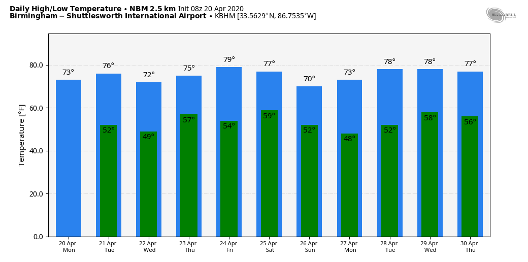
DRIER AIR ARRIVING: After another day of heavy rain and strong to severe thunderstorms, improving weather headlines the Alabama forecast today as dry air returns. Morning clouds will give way to afternoon sunshine; the high will be in the low 70s. The average high for Birmingham on April 20 is 76. Tuesday will be another rain-free day with a good supply of sunshine; the high will be in the mid to upper 70s.
MORE STORMS: The day Wednesday will be dry, but clouds will increase by afternoon. Another spring storm system will bring rain and thunderstorms to the state late Wednesday night into Thursday morning; for now it looks like the main chance of rain comes from midnight Wednesday night through noon Thursday.
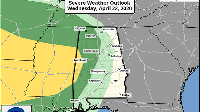
The Storm Prediction Center has a part of far west Alabama in a slight risk of severe weather (level 2 of 5) in its outlook that runs through 7 a.m. Thursday. A marginal risk (level 1 of 5) is defined as far east as Birmingham.
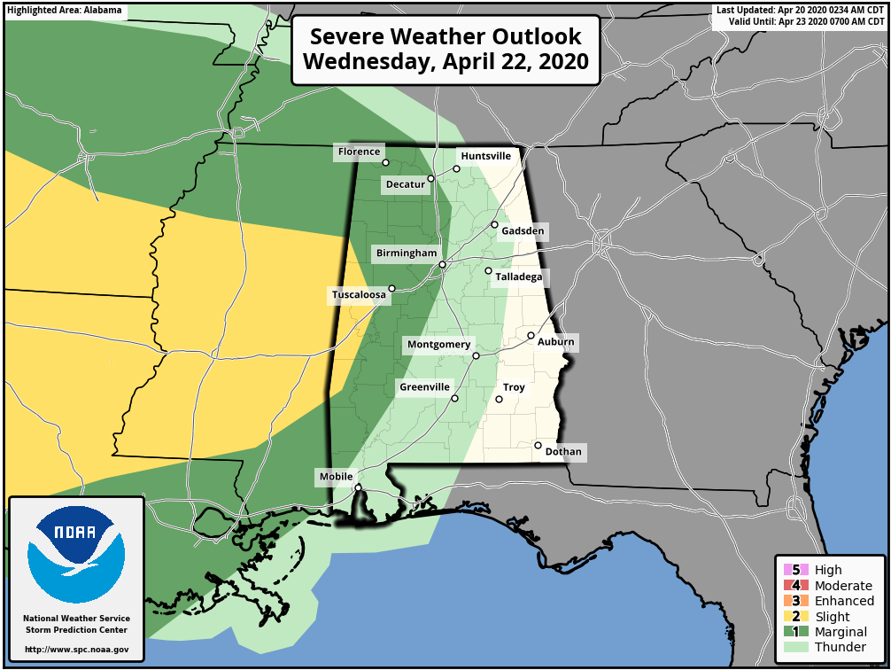
This threat is conditional; much depends on the thermodynamic environment (instability). Hopefully, with the storms coming through at a time when the air tends to be most stable, that will mitigate the severe weather threat to some degree. Once we get within 60 hours of the event, and within range of the high-resolution, convection-allowing models, we will have a much better look at this. Rain amounts of 1-2 inches look likely, and some flooding can’t be ruled out with the saturated soil conditions we have now in Alabama.
FRIDAY AND THE WEEKEND: Most of the day Friday will be dry, but another fast-moving system will bring a chance of rain and thunderstorms to the state Friday night. It’s too early to know whether this will be another event with severe thunderstorm potential. The rain will push out of the state Saturday morning, followed by a clearing sky. Sunday looks dry and pleasant, with ample sunshine and a high around 70 degrees.
NEXT WEEK: For now Monday and Tuesday look dry, followed by a chance of rain and thunderstorms by Wednesday or Thursday.
SUNDAY’S STORMS: A fast-moving thunderstorm produced high straight-line winds, most likely in the 50-90 mph range, across Chilton, Coosa and Tallapoosa counties early Sunday morning, knocking down hundreds of trees and causing at least two injuries. Then, more severe storms last night moved across the southern quarter of the state, producing damage at places like Troy and into the Wiregrass section of southeast Alabama.
Rain totals yesterday included:
- Jemison — 5.65 inches
- Coker — 4.75
- Bibbville — 4.13
- Hueytown — 3.8
- Northport — 3.13
- Crestwood — 2.66
- Mountain Brook — 2.42
- Carbon Hill — 2.12
- Weaver — 1.87
ON THIS DATE IN 1920: Tornadoes in Mississippi and Alabama killed 219 people. Six tornadoes of F4 intensity were reported. Aberdeen, Mississippi, was hard hit by an F4 tornado that killed 22 people. This same tornado killed 20 in Marion County, Alabama. Nine people in one family died in Winston County.
WEATHER BRAINS: You can listen to our weekly 90-minute show anytime on your favorite podcast app. This is the show all about weather featuring many familiar voices, including the meteorologists at ABC 33/40.
CONNECT: You can find me on the major social networks:
Facebook
Twitter
Instagram
Pinterest
Snapchat: spannwx
For more weather news and information from James Spann and his team, visit AlabamaWx.


