Scott Martin: Mother Nature makes sure Alabama knows summer is here
HIGHS FOR FRIDAY:
- Birmingham — 90 degrees
- Anniston — 87
- Calera — 88
- Montgomery — 92
- Troy — 92
- Tuscaloosa — 90
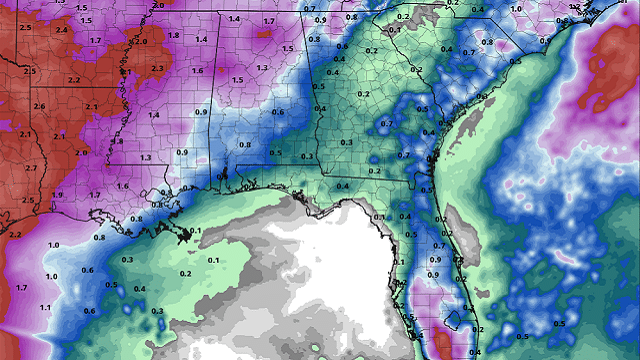
PROJECTED RAINFALL: Projected rain amounts through the end of next week show that we may have a wide spread of totals across Alabama, ranging from as small as just over one-quarter of an inch to as high as 2 inches. We’ll see how that goes with the coverage, especially on Tuesday through Thursday.
THE ALABAMA WEEKEND: The first day of summer will feel like summer. Today will be hot with a mix of sun and clouds. While just about all of Alabama will stay dry, a few locations may see a brief, isolated shower, especially in the eastern parts of the state. Highs will be in the lower to mid-90s.
Other than the location of a few brief isolated afternoon showers, Sunday will be a near carbon-copy of today — partly cloudy and hot with a very slight chance of isolated afternoon showers, mainly over northwestern Alabama. Highs will be in the lower to mid-90s.
THE WORK WEEK AHEAD: Rain chances will be on the rise for the first half of the work week as a trough deepens over the eastern half of the country. Monday will feature mostly clear to partly cloudy skies with a chance of scattered, mainly afternoon storms. Highs will be in the lower to mid-90s.
Tuesday will feature more clouds and rain chances becoming likely. Scattered to numerous storms will be possible, mainly during the afternoon and evening.
Highs will be in the upper 80s to the lower 90s.
Wednesday will feature mostly cloudy skies, with scattered to numerous storms becoming likely again during the main heating of the day and into the evening as what looks like a front will push through much of the state. Highs will be in the lower to upper 80s.
That front looks to continue slowly moving through southern Alabama on Thursday, keeping rain chances elevated but not quite as high as the previous two days. Skies will range from mostly sunny to partly cloudy from northwest to southeast, with highs in the mid to upper 80s.
Friday looks to be much drier at this point with a mix of sun and clouds. I can’t completely rule out a few isolated to scattered afternoon storms, but chances look to be much lower than on Thursday. Highs will be in the mid-80s to the lower 90s.
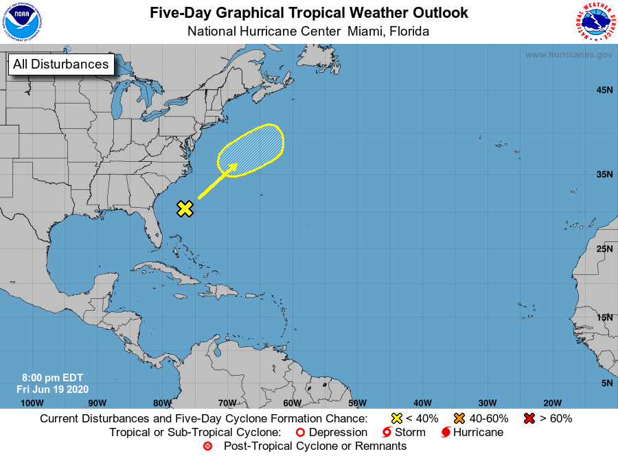
TROPICS: A disturbance off the southeastern U.S. Atlantic Coast poses no threat to the mainland as it is expected to move off to the northeast. There is a very minuscule risk that it may start to form some subtropical characteristics on Sunday, but cooler waters will shunt any further development after that. The rest of the Atlantic Basin remains quiet.
ON THIS DATE IN 1682: A major tornado ripped through southwestern Connecticut, passing through Stratford, Milford and New Haven, and then into Long Island Sound.
ON THIS DATE IN 1928: A farmer near Greensburg, Kansas, looked up into the heart of a tornado. He described its walls as rotating clouds lit with constant flashes of lightning and a strong, gassy odor with a screaming, hissing sound.
BEACH FORECAST CENTER: Get the latest weather and rip current forecasts for the beaches from Bay St. Louis, Mississippi, to Panama City Beach, Florida, on our Beach Forecast Center page. There, you can select the forecast of the region you are interested in.
For more weather news and information from James Spann, Scott Martin and other members of the James Spann team, visit AlabamaWx.