James Spann: Scattered to numerous showers, storms for Alabama Tuesday and Wednesday
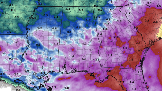
RADAR CHECK: We have a number of showers and thunderstorms across Alabama this afternoon; they are moving to the west and northwest around the circulation of a broad upper low over the region. Storms are below severe limits, but are producing heavy rain and gusty winds in a few spots.

Away from the showers, the sky is partly to mostly cloudy with temperatures mostly in the 80s. Showers will linger across the state tonight but slowly decrease in number.
TUESDAY/WEDNESDAY: The weather pattern remains unsettled both days, with more clouds than sun and scattered to numerous showers and thunderstorms. Most of them will come during the afternoon and evening, but a few late-night or morning showers can’t be ruled out. Highs will remain in the 80s. Rain distribution will remain very uneven, as we expect in summer, but most places should see a decent downpour or two.
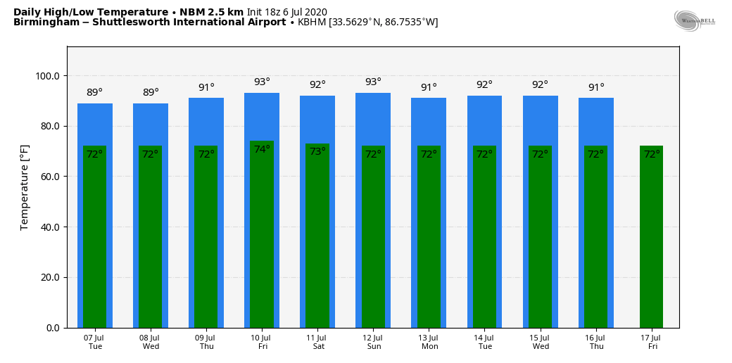
THURSDAY THROUGH THE WEEKEND: Showers should become fewer in number Thursday and Friday as the upper low lifts away from the region. Still, we will have scattered, mostly afternoon and evening showers and thunderstorms both days. The sky will be partly sunny with highs around 90 degrees. Then, the weekend looks mostly hot and dry with only isolated showers Saturday and Sunday. Heat levels will continue to tick up a bit, with highs in the low 90s Saturday and Sunday, right at seasonal averages for mid-July in Alabama.
NEXT WEEK: For now it looks like very typical midsummer weather through the week — partly sunny days with random, scattered, mostly afternoon and evening showers and thunderstorms daily. Highs will be in the 89- to 93-degree range most afternoons.
TROPICS: Tropical Storm Edouard in the North Atlantic is becoming post-tropical and is far from land. A fast-moving tropical wave continues to produce disorganized showers and thunderstorms a few hundred miles east of the Windward Islands. This disturbance has not become any better organized today and development is becoming unlikely. The wave is forecast to move through the Lesser Antilles on Tuesday and could produce locally heavy rainfall and gusty winds on some of those islands.
Closer to home, a surface low is moving through central Georgia. The low is forecast to move northeastward near the coast of the Carolinas and the mid-Atlantic during the next few days. No development is expected while the low remains over land; however, some development will be possible if the system moves over water later this week. Regardless of development, the low is forecast to produce locally heavy rainfall that could cause flash flooding across portions of the Southeast during the next couple of days.
The Gulf of Mexico is quiet.
ON THIS DATE IN 1928: A hailstone weighing 1.5 pounds fell in Potter, Nebraska. With a circumference of 17 inches, this appeared to be the largest hailstone in the world at that time.
BEACH FORECAST: Click here to see the AlabamaWx Beach Forecast Center page.
WEATHER BRAINS: You can listen to our weekly 90-minute show anytime on your favorite podcast app. This is the show all about weather featuring many familiar voices, including the meteorologists at ABC 33/40.
CONNECT: You can find me on the major social networks:
Facebook
Twitter
Instagram
Pinterest
Snapchat: spannwx
For more weather news and information from James Spann and his team, visit AlabamaWx.


