James Spann: Scattered showers, storms return to Alabama Wednesday
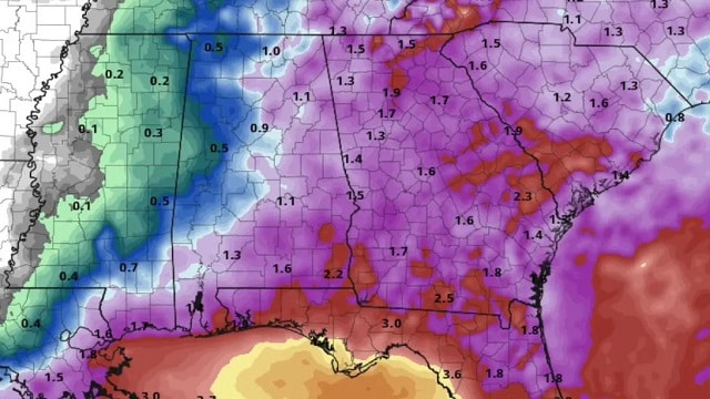
MOSTLY DRY: Most of Alabama is rain-free this afternoon in an unusually dry air mass for summer, with just a few showers over the southeast part of the state. With a mostly sunny sky, temperatures are at or just over 90 degrees in most spots, but dew points have fallen into the 50s over the northern counties of the state and humidity values are mostly in the 30-40% range. Tonight will be mostly fair and pleasant.
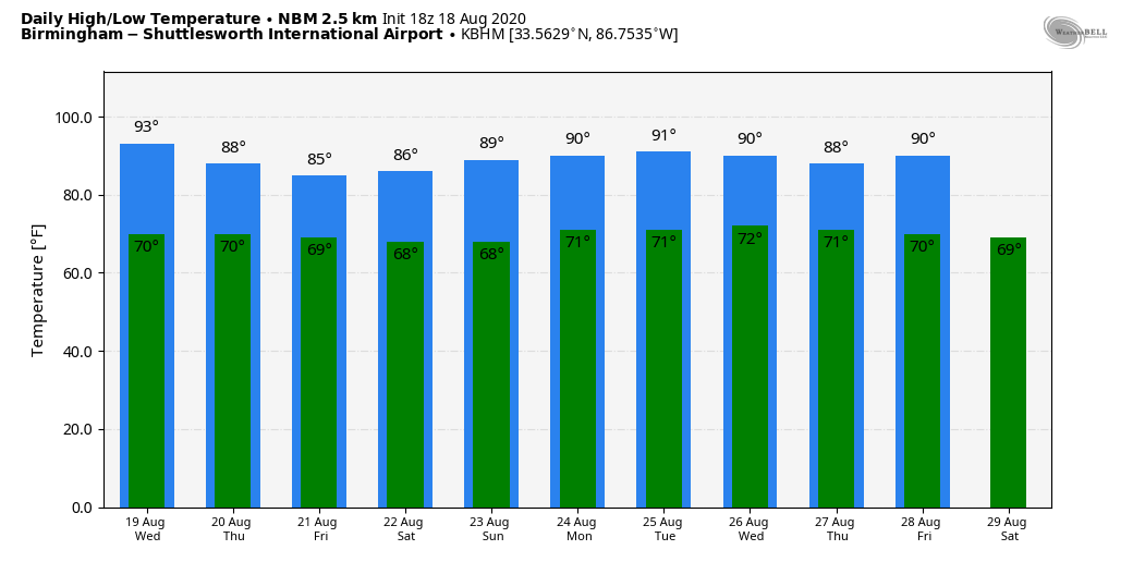
REST OF THE WEEK: Moisture levels rise, and scattered, mostly afternoon and evening showers and thunderstorms return Wednesday with a high close to 90. On Thursday and Friday, the sky will be occasionally cloudy with scattered to numerous showers and thunderstorms. Highs will drop into the mid 80s on both days.
THE ALABAMA WEEKEND: We will maintain the risk of a few scattered showers and thunderstorms Saturday with a partly sunny sky, but Sunday will be mostly sunny with only isolated showers as the air becomes drier. Highs for the weekend will be in the 88- to 91-degree range.
NEXT WEEK: The weather will be greatly dependent on potential tropical mischief in the Gulf of Mexico, and there is no skill in forecasting this a week in advance. For now, we will just roll with the typical summer forecast through the week with highs around 90.
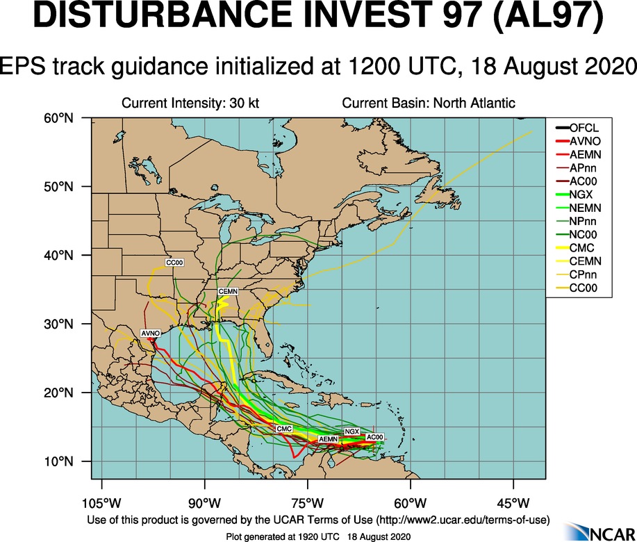
TROPICS: The National Hurricane Center is now giving a high chance of two tropical depressions or storms to form in the Atlantic main development region over the next few days.
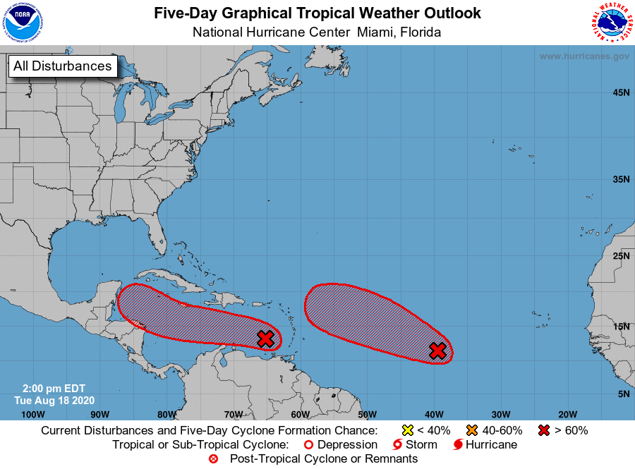
INVEST 97L: The lead wave, now in the eastern Caribbean, continues to produce an area of disorganized thunderstorms and gusty winds. This wave is moving quickly westward at about 20 mph. Significant development is unlikely while it moves across the eastern and central Caribbean Sea during the next day or two. After that time, however, the wave is forecast to slow down, and a tropical depression will likely form late this week or this weekend when it reaches the northwestern Caribbean Sea.
There is a fair chance this will enter the Gulf of Mexico in five to six days, but it is too early to know what, if any, part of the contiguous U.S. will be affected.
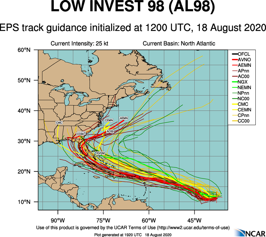
INVEST 98L: The trailing wave in the central Atlantic is about 1,300 miles east of the Lesser Antilles and is producing a concentrated area of showers and thunderstorms. Environmental conditions are conducive for development, and a tropical depression is expected to form within the next couple of days while the system moves west-northwestward at 15 to 20 mph across the central and western portions of the tropical Atlantic. Like 97L, there is no way of knowing now the ultimate destination or intensity, or any potential impact on Florida or the Southeast. Just another one to watch.
The Gulf of Mexico will remain quiet through this week.
ON THIS DATE IN 1983: Alicia became a major hurricane and made landfall an hour later on Galveston Island with maximum sustained winds of 100 mph and a minimum barometric pressure of 962 millibars as measured by aircraft reconnaissance, making it a low-end Category 3 on the Saffir–Simpson hurricane scale. Alicia was the first hurricane to strike the continental United States since Hurricane Allen moved ashore in south Texas in August 1980, ending the longest break in contiguous U.S. hurricane landfalls of the 20th century. The hurricane was also the first major hurricane to hit the Greater Houston area since Hurricane Carla in 1961.
Widespread damage was wrought in Galveston and Houston, where thousands of homes were destroyed. In downtown Houston, nearly all skyscrapers lost approximately half of their lower-level windows, littering the urban streets with debris. Widespread power outages and flooding affected much of southeast Texas, with observed rainfall totals peaking just under 10 inches. In addition to the strong winds, rough surf and heavy rain, Alicia also generated 22 tornadoes around the Houston-Galveston area; most were rated F0, but the strongest, an F2, tore through Corsicana farther north.
BEACH FORECAST: Click here to see the AlabamaWx Beach Forecast Center page.
WEATHER BRAINS: You can listen to our weekly 90-minute show anytime on your favorite podcast app. This is the show all about weather featuring many familiar voices, including the meteorologists at ABC 33/40.
CONNECT: You can find me on the major social networks:
Facebook
Twitter
Instagram
Pinterest
Snapchat: spannwx
For more weather news and information from James Spann and his team, visit AlabamaWx.


