James Spann: Severe storms possible over north Alabama Friday
James Spann forecasts a quiet day for Alabama as Laura rages westward from Alabama NewsCenter on Vimeo.
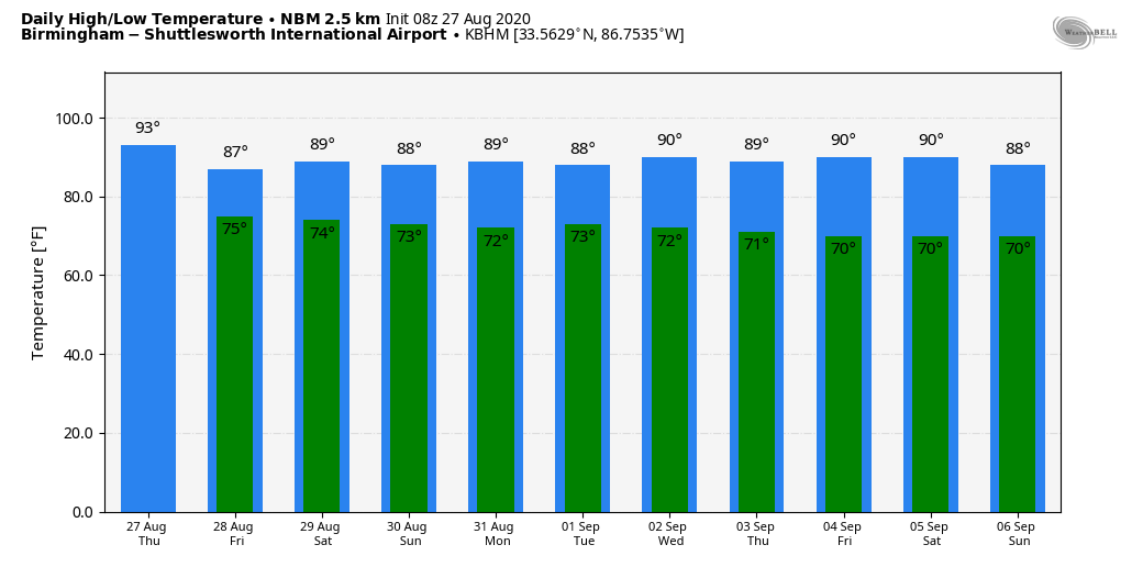
QUIET MORNING: While Hurricane Laura is moving northward well to the west of Alabama, our weather is quiet this morning. The direct wind and rain associated with Laura will remain well to the west of Alabama. A decent part of the day will be dry with a partly sunny sky, but we do expect a few scattered showers and thunderstorms by mid to late afternoon into tonight. Today will be hot and humid, with a high between 89 and 93 degrees for most communities.
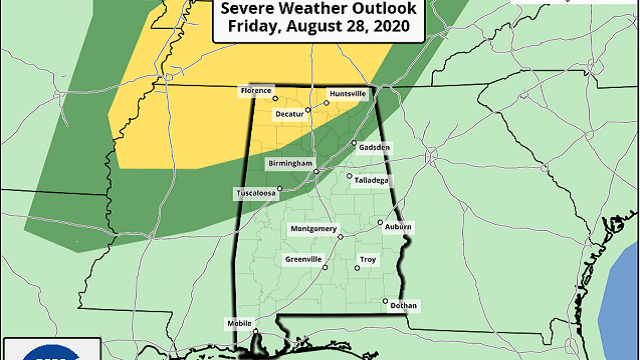
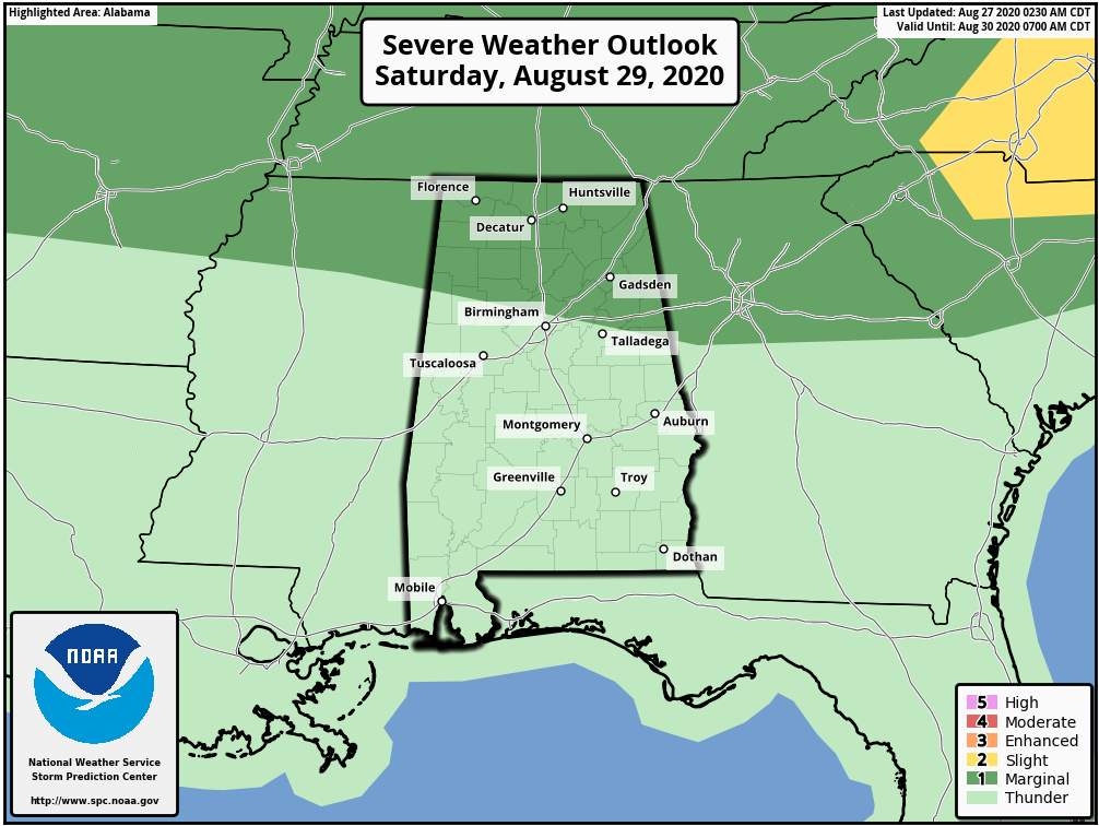
FRIDAY: As the remnant circulation of Laura turns eastward north of our state, we will have veering of the wind with altitude over the northern counties, which could set the stage for a few rotating showers or thunderstorms during the day. The Storm Prediction Center has a slight risk (level 2 of 5) defined for areas as far south as Scottsboro, Vinemont and Vernon, and there is a marginal risk (level 1 of 5) as far south as I-59 (Gadsden to Birmingham to Tuscaloosa).
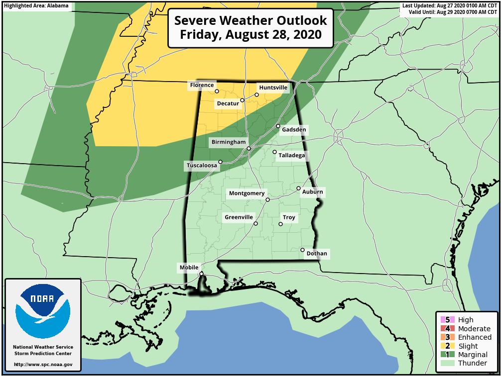
A few isolated tornadoes will be possible, especially during the afternoon and evening peak of the daytime heating process. Typically tornadoes associated with tropical systems are short-lived and can be hard to warn for since the storms typically are low-topped and sometimes literally under the radar. Just be weather aware and put yourself in a position to hear warnings in the event they are needed. Otherwise, the sky will be mostly cloudy with a good chance of occasional showers and a few thunderstorms. The high will be in the mid 80s.
THE ALABAMA WEEKEND: A deep pool of tropical moisture remains in place, meaning scattered to numerous showers and thunderstorms both days. A few strong storms are possible Saturday afternoon over the northern third of the state, where the SPC has defined a marginal risk (level 1 of 5).
The weekend won’t be a total washout, however; the sky will be occasionally cloudy both days with highs in the mid to upper 80s.
NEXT WEEK: Moist, tropical air will stay in place through the week, meaning the chance of at least scattered showers and thunderstorms daily. Highs will be mostly in the upper 80s, lows in the low 70s.
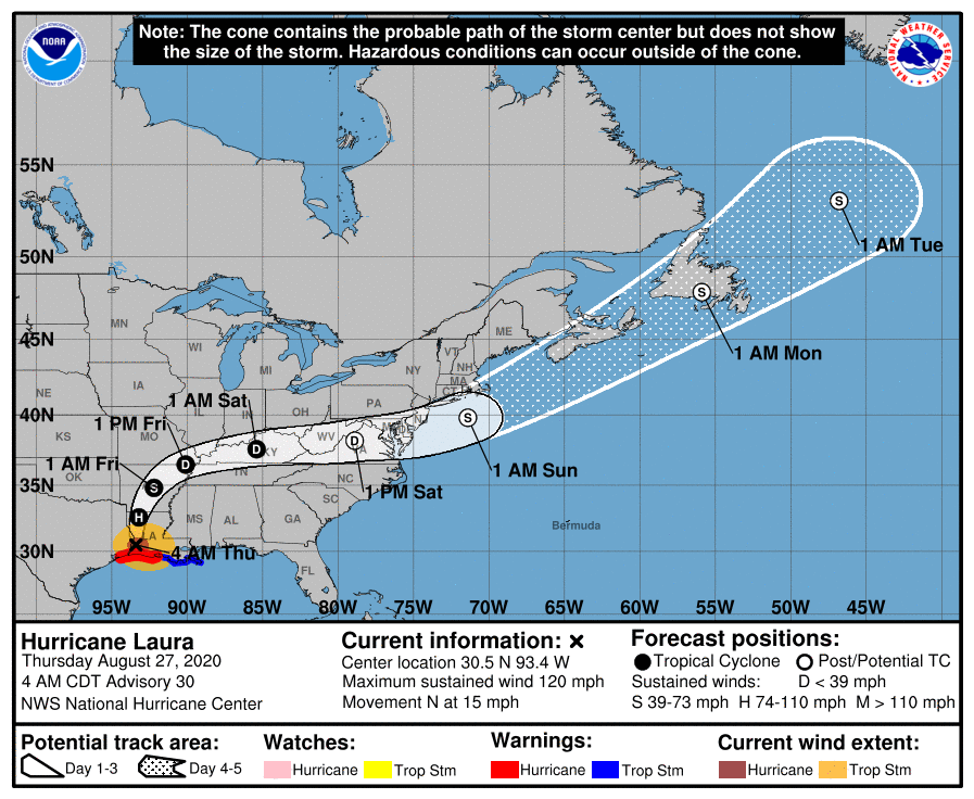
LAURA IS INLAND: Laura made landfall early this morning near Cameron, Louisiana, with sustained winds at 150 mph, Category 4 strength. Winds have decreased to 110 mph as of 5 a.m., and the center was 45 miles northwest of Lake Charles at the time. The circulation center will be close to Shreveport later this morning; from there it moves through Arkansas, and then turns eastward as it gets caught up in the mid-latitude westerly winds aloft.
Elsewhere in the tropics, a new tropical wave has emerged off the coast of Africa; for now the National Hurricane Center gives it a low chance of development over the next five days as it moves westward across the open Atlantic. The Caribbean and the Gulf are now quiet.
ON THIS DATE IN 2005: Hurricane Katrina reached Category 3 intensity in the Gulf of Mexico about 335 miles south-southeast of the mouth of the Mississippi River with maximum sustained winds of 115 mph.
BEACH FORECAST: Click here to see the AlabamaWx Beach Forecast Center page.
WEATHER BRAINS: You can listen to our weekly 90-minute show anytime on your favorite podcast app. This is the show all about weather featuring many familiar voices, including the meteorologists at ABC 33/40.
CONNECT: You can find me on the major social networks:
Facebook
Twitter
Instagram
Pinterest
Snapchat: spannwx
For more weather news and information from James Spann and his team, visit AlabamaWx.