James Spann: Dry Labor Day for Alabama
WARM, PLEASANT DAY: As advertised, this is a sunny, warm, pleasant Labor Day across Alabama. The humidity is low, and temperatures are mostly in the mid to upper 80s at mid-afternoon. Tonight will be clear with a low in the 60s.
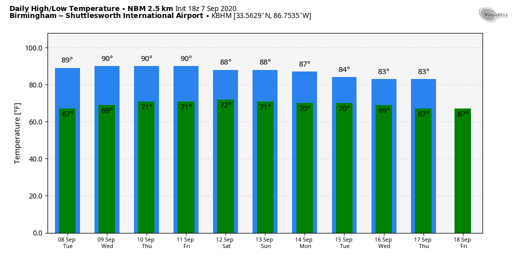
REST OF THE WEEK: A rather uneventful weather pattern will persist across the Deep South for the rest of the week. Tuesday and Wednesday look dry with a good supply of sunshine both days; then we will bring in a chance of scattered, mostly afternoon and evening showers Thursday and Friday as moisture levels rise a bit, but the rain won’t be especially heavy, and many places will stay dry. Highs will be between 85 and 90 degrees, right at seasonal averages for early September.
THE ALABAMA WEEKEND: Look for a mix of sun and clouds Saturday and Sunday with the chance of random, scattered, mostly afternoon and evening showers and storms. Odds of any one spot getting wet both days will be in the 40-50% range, and highs will remain in the mid to upper 80s.
NEXT WEEK: The weather won’t change much; a few scattered showers or storms are possible during the first half of the week, and we project a gradual downward trend in temperatures with highs in the low to mid 80s by Thursday and Friday.
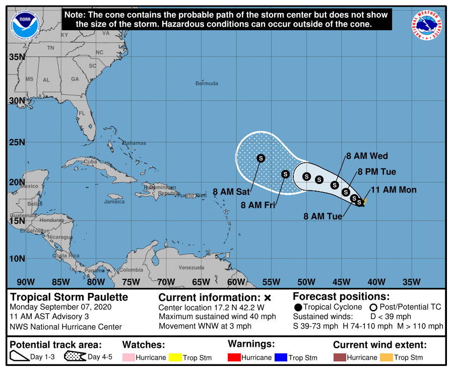
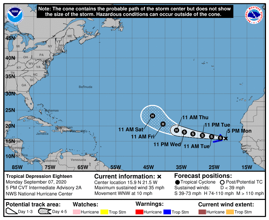
TROPICS: TD 17 was upgraded to Tropical Storm Paulette this morning in the open Atlantic, about 1,300 miles east of the northern Leeward Islands. Sustained winds are 40 mph, and it is expected to remain below hurricane strength over the next five days. It will begin to gain latitude later this week and is expected to recurve into the Atlantic well east of the U.S.
In the eastern Atlantic, TD 18 is expected to become Tropical Storm Rene tonight. It is expected to become a hurricane by Thursday, but the system will turn northward late this week and is no threat to the U.S.
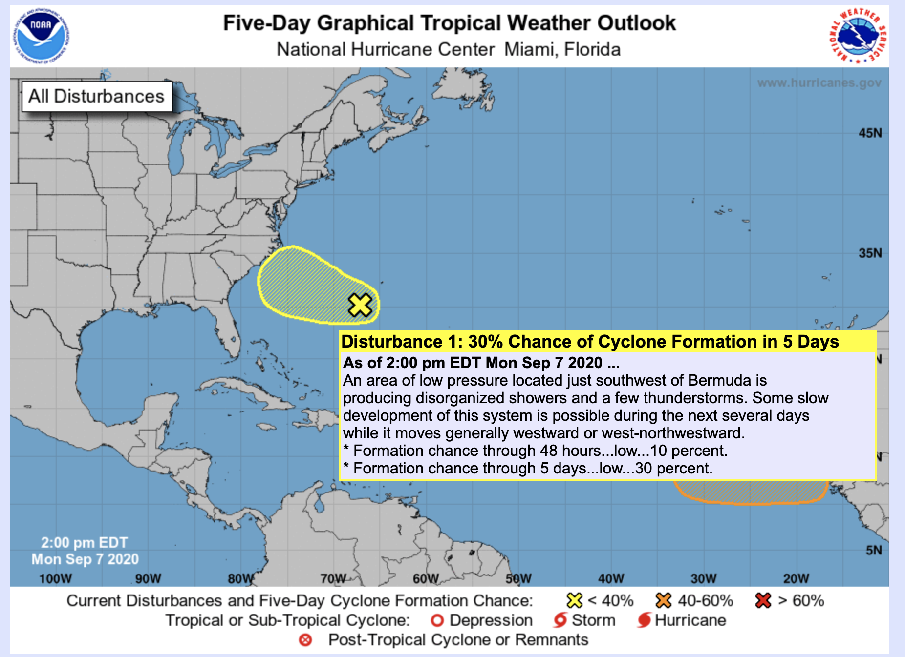
The National Hurricane Center is also monitoring an area of low pressure just southwest of Bermuda that is producing disorganized showers and a few thunderstorms. Some slow development of this system is possible during the next several days while it moves generally westward or west-northwestward toward the U.S. Atlantic Coast. For now it has only a 30% chance of becoming a tropical depression or storm over the next five days.
The Gulf of Mexico will remain quiet this week.
ON THIS DATE IN 1970: A lightning bolt struck a group of football players at Gibbs High School in St. Petersburg, Florida. The lightning killed two people and injured 22 others. All 38 players and four coaches were knocked off their feet.
ON THIS DATE IN 2004: Hurricane Ivan passed over Grenada, battering several of the Windward Islands. As it entered the Caribbean Sea, Ivan reintensified rapidly and became a Category 5 hurricane, just north of the Windward Netherlands Antilles (Curaçao and Bonaire) and Aruba on Sept. 9, with winds reaching 160 mph. A few days later it would make landfall on the central Gulf Coast.
BEACH FORECAST: Click here to see the AlabamaWx Beach Forecast Center page.
WEATHER BRAINS: You can listen to our weekly 90-minute show anytime on your favorite podcast app. This is the show all about weather featuring many familiar voices, including the meteorologists at ABC 33/40.
CONNECT: You can find me on the major social networks:
Facebook
Twitter
Instagram
Pinterest
Snapchat: spannwx
For more weather news and information from James Spann and his team, visit AlabamaWx.


