Hurricane warning extended to Alabama Gulf Coast as Sally churns

TROPICAL STORM SUMMARY OF 10 A.M.
———————————————–
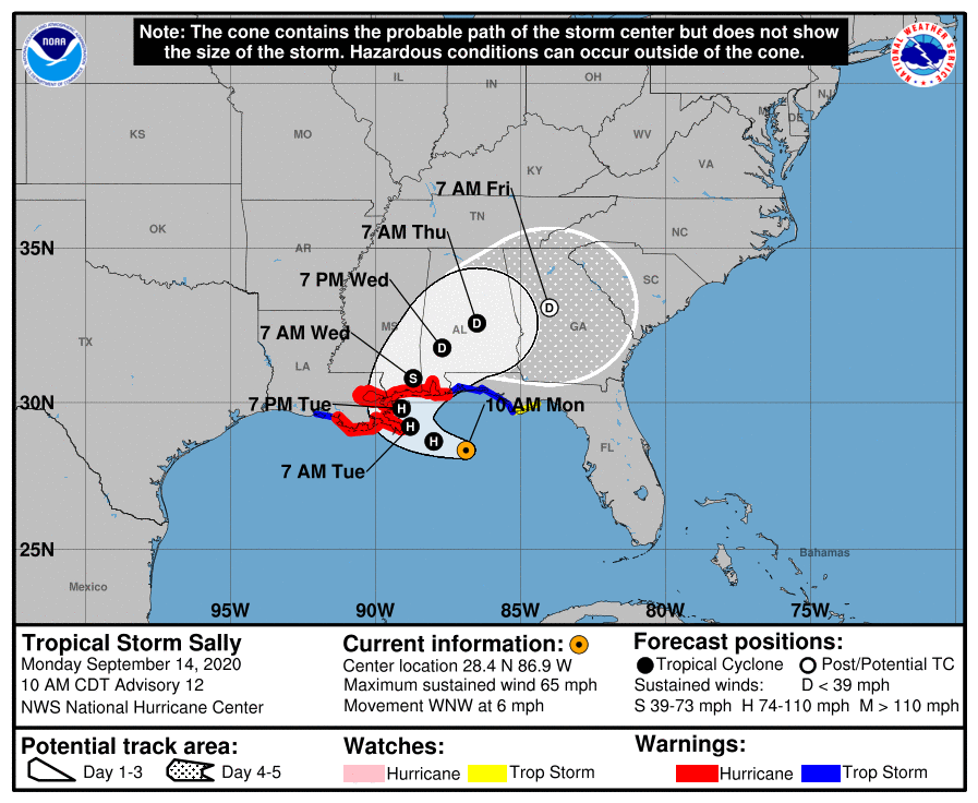
LOCATION…28.4N 86.9W
ABOUT 140 MI…230 KM ESE OF THE MOUTH OF THE MISSISSIPPI RIVER
ABOUT 185 MI…295 KM SE OF BILOXI MISSISSIPPI
MAXIMUM SUSTAINED WINDS…65 MPH…100 KM/H
PRESENT MOVEMENT…WNW OR 285 DEGREES AT 6 MPH…9 KM/H
MINIMUM CENTRAL PRESSURE…991 MB…29.27 INCHES
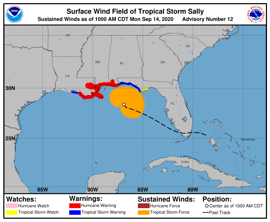
WATCHES AND WARNINGS
——————–
CHANGES WITH THIS ADVISORY:
The Tropical Storm Warning and Hurricane Watch from the
Mississippi/Alabama border to the Alabama/Florida Border has been
changed to a Hurricane Warning.
SUMMARY OF WATCHES AND WARNINGS IN EFFECT:
A Storm Surge Warning is in effect for…
• Port Fourchon Louisiana to the Alabama/Florida border
• Lake Pontchartrain, Lake Maurepas, and Lake Borgne
• Mobile Bay
A Hurricane Warning is in effect for…
• Morgan City Louisiana to the Alabama/Florida border
• Lake Pontchartrain and Lake Maurepas including metropolitan New Orleans
A Tropical Storm Warning is in effect for…
• Alabama/Florida border to Indian Pass Florida
• Intracoastal City Louisiana to the west of Morgan City
A Tropical Storm Watch is in effect for…
• Indian Pass to Ochlockonee River Florida
DISCUSSION AND OUTLOOK
———————-
Data from an Air Force Reserve Hurricane Hunter aircraft indicate that the center of Sally has reformed to the east of the previous estimated location. At 10 a.m., the center of Tropical Storm Sally was located near latitude 28.4 North, longitude 86.9 West. Sally is moving toward the west-northwest near 6 mph (9 km/h). This general motion is expected to continue today, followed by a decrease in forward speed and a turn toward the northwest tonight and a northward turn sometime on Tuesday. On the forecast track, the center of Sally will move over the north-central Gulf of Mexico today, approach southeastern Louisiana tonight, and make landfall in the hurricane warning area on Tuesday or Tuesday night. Afterward, Sally is expected to move slowly north-northeastward near the northern Gulf Coast through Wednesday.
Maximum sustained winds are near 65 mph (100 km/h) with higher gusts. Strengthening is expected over the next day or so, and Sally is forecast to become a hurricane by tonight, with additional strengthening possible before the center crosses the northern Gulf Coast.
Tropical-storm-force winds extend outward up to 125 miles (205 km) from the center.
The latest minimum central pressure estimated from reconnaissance aircraft data is 991 MB (29.27 inches).
HAZARDS AFFECTING LAND
———————-
STORM SURGE: The combination of a dangerous storm surge and the tide will cause normally dry areas near the coast to be flooded by rising waters moving inland from the shoreline. The water could reach the following heights above ground somewhere in the indicated areas if the peak surge occurs at the time of high tide…
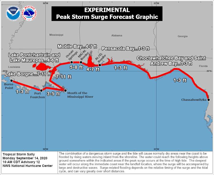
• The mouth of the Mississippi River to Ocean Springs, MS including Lake Borgne…7-11 ft
• Ocean Springs, MS to MS/AL Border…5-8 ft
• MS/AL Border to AL/FL Border including Mobile Bay…4-7 ft
• Lake Pontchartrain and Lake Maurepas…4-6 ft
• Port Fourchon, LA to Mouth of the Mississippi River…3-5 ft
• AL/FL Border to Chassahowitzka, FL including Pensacola Bay, Choctawhatchee Bay, and Saint Andrew Bay…1-3 ft
• Burns Point, LA to Port Fourchon, LA…1-3 ft
Overtopping of local levees outside of the Hurricane and Storm Damage Risk Reduction System is possible where local inundation values may be higher than those shown above.
The deepest water will occur along the immediate coast in areas of onshore winds, where the surge will be accompanied by large and damaging waves. Surge-related flooding depends on the relative timing of the surge and the tidal cycle and can vary greatly over short distances. For information specific to your area, please see products issued by your local National Weather Service forecast office.
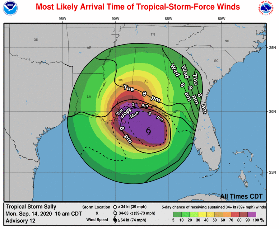
WIND: Hurricane conditions are expected to begin within the hurricane warning area tonight. Tropical storm conditions are possible within the watch area today and are expected to begin within the warning area later today.
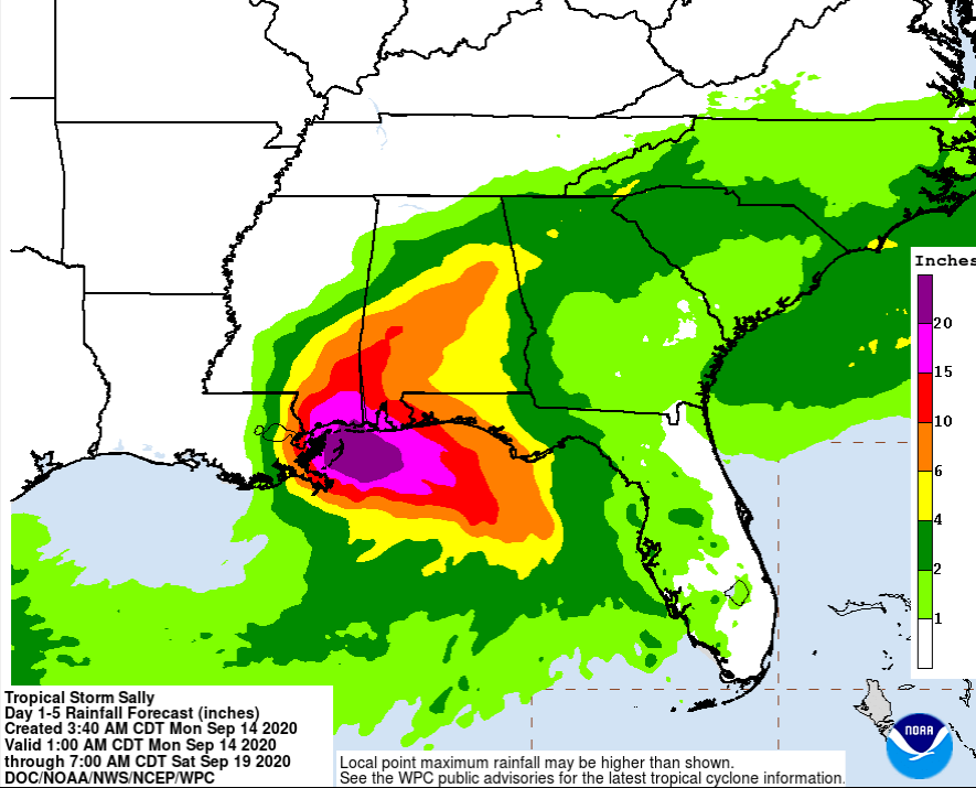
RAINFALL: Sally is expected to be a slow-moving system as it approaches land, producing 8 to 16 inches of rainfall with isolated amounts of 24 inches over portions of the central Gulf Coast from the western Florida Panhandle to far southeast Louisiana through the middle of the week. Life-threatening flash flooding is likely. In addition, this rainfall will likely lead to widespread minor to isolated major flooding on area rivers.
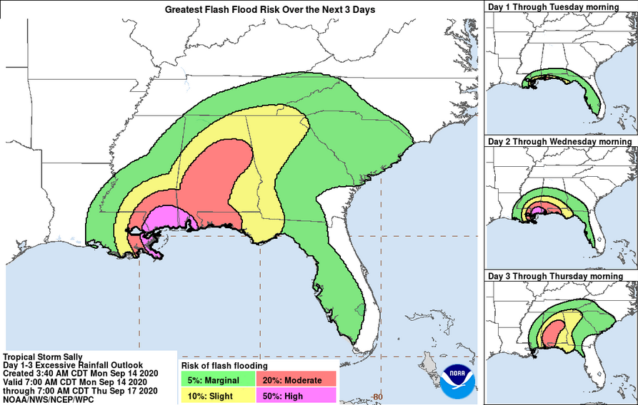
Sally is forecast move farther inland early Wednesday and track into the Southeast with rainfall of 6 to 12 inches possible across portions of inland southeast Mississippi and Alabama. Significant flash and urban flooding is likely, as well as widespread minor to moderate flooding on some rivers.
Further heavy rain is then anticipated across portions of eastern Tennessee, northern Georgia, and western Carolinas Thursday into Friday. Flash, urban, and minor river flooding are possible across this region.
Outer bands of Sally are expected to produce additional rainfall of 1 to 3 inches across the Florida peninsula today. This rainfall may produce flash and urban flooding and prolong high flows and ongoing minor flooding on rivers across central Florida.
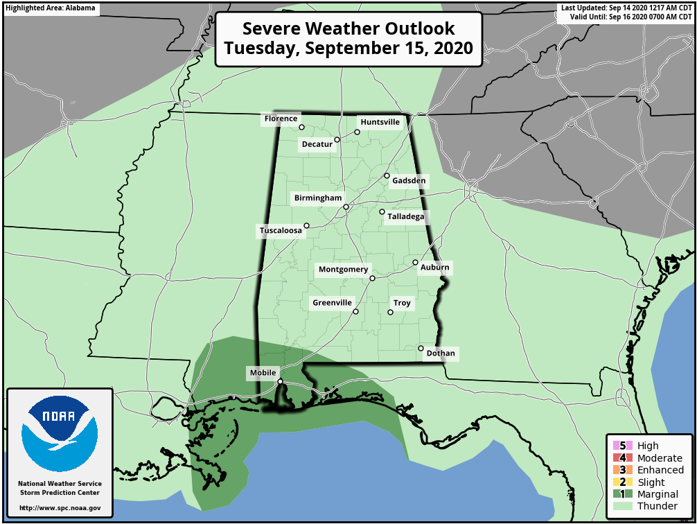
TORNADOES: A tornado or two may occur this afternoon through Tuesday over coastal areas of the Florida Panhandle, Mississippi, Alabama, and extreme southeastern Louisiana.
SURF: Swells from Sally will continue to affect areas from the west coast of the Florida peninsula westward through the coast of southeastern Louisiana during the next couple of days. These swells are likely to cause life-threatening surf and rip current conditions. Please consult products from your local weather office.
Jeff Collier, Mayor of Dauphin Island, advises people to evacuate the west end of the island… pic.twitter.com/pq7qCAM1su
— James Spann (@spann) September 14, 2020
For more weather news and information from Scott Martin and the rest of the James Spann team, visit AlabamaWx.


