James Spann: A few showers for Alabama today, more widespread rain on Thursday
James Spann has the Alabama forecast for midweek from Alabama NewsCenter on Vimeo.
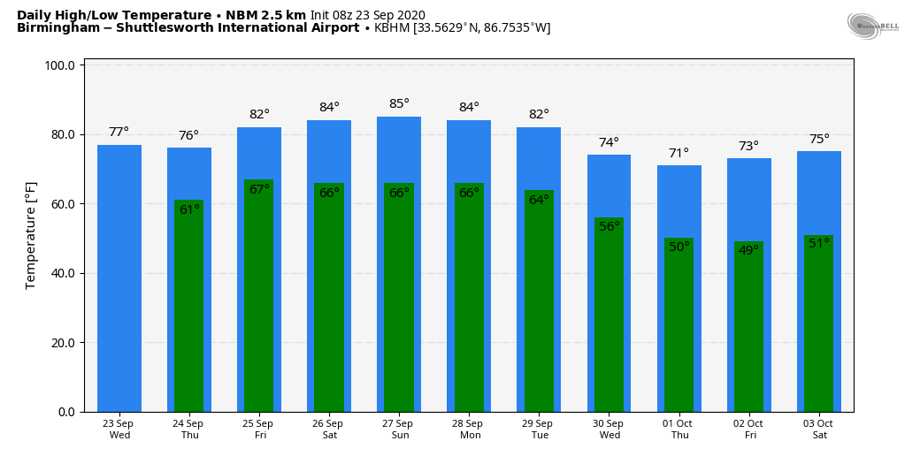
RADAR CHECK: We have a few scattered showers over west Alabama early this morning, but most of the state is dry. Temperatures are in the 50s across northeast Alabama, with 60s elsewhere — not as cool as Tuesday morning, due to a cloud cover. Clouds stay in place today with the potential for a few showers, mainly over the western half of the state; the high will be in the mid-70s for most communities. Showers will increase statewide tonight as the remnant circulation of Beta approaches.
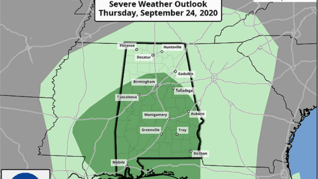
THURSDAY: Thursday will be a wet day for the state. A few thunderstorms are possible, especially over the southern counties, where some surface-based instability develops south of a northward-moving warm front. The Storm Prediction Center has introduced a low-end, marginal risk of severe thunderstorms for the southern two-thirds of Alabama.
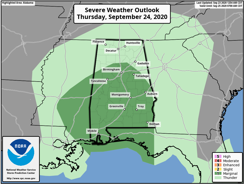
A few storms over the southern half of the state could produce strong, gusty winds, and there is an outside risk of a brief, isolated tornado. We will watch radar trends closely during the day, but this doesn’t seem to be a major threat. The heaviest rain is expected over the northwest counties, where amounts of 2 to 3 inches are possible. This is where they received little if any rain from Hurricane Sally a week or so ago. The rest of Alabama can expect amounts from one-half to 2 inches. The flash flood risk looks relatively low.
FRIDAY AND THE WEEKEND: Models have trended drier. We will still mention a chance of showers Friday, especially over the eastern half of the state. The day will be warmer and more humid, with a high in the low to mid-80s as the warm front pushes north of the region. Look for a mix of sun and clouds Saturday and Sunday with just a few widely scattered showers both days. The best chance of showers will come from noon to 10 p.m., but it now looks like a decent part of the weekend will be dry. Warm, muggy conditions will continue, with highs between 84 and 87 for most communities, a little above average for late September.
NEXT WEEK: Monday will be partly sunny and warm with just a few widely scattered showers around. Showers become more likely Tuesday as a cold front pushes through the state. Much cooler, drier air rolls in Wednesday through Friday, with highs dropping near 70 and lows around 50. Many communities will see lows in the 40s over north and central Alabama by Thursday and Friday mornings.
FOOTBALL WEATHER: UAB travels to Mobile to take on South Alabama Thursday night (6:30 kickoff). The sky will be mostly cloudy, but there’s just a small risk of a shower during the game. Temperatures will fall from the low 80s at kickoff into the upper 70s by the final whistle.
For the high school games Friday night, the sky will be mostly cloudy, but the risk of a shower for any one specific stadium now looks small. Temperatures will fall slowly into the mid to upper 70s.
Saturday, Auburn will host Kentucky at Jordan Hare Stadium (11 a.m. kickoff). Expect a partly sunny sky with a brief shower possible. Temperatures will rise into the low 80s during the game.
Alabama travels to Columbia, Missouri, to take on Mizzou Saturday (6 p.m. kickoff). The sky will be clear, with temperatures falling from near 82 at kickoff through the 70s during the second half.
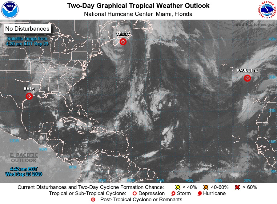
TROPICS: Beta is now a remnant low over Louisiana, Teddy is a post-tropical system moving into Nova Scotia, and Paulette has dissipated (again) in the eastern Atlantic. The rest of the Atlantic basin, for a change, is very quiet.
ON THIS DATE IN 1975: Eloise made landfall as a Category 3 hurricane near Panama City Beach, generating wind gusts of 155 mph, which demolished hundreds of buildings in the area. The storm’s severe winds, waves and storm surge left numerous beaches, piers and other coastal structures heavily impaired.
Wind-related damage extended into inland Alabama and Georgia. Farther north, torrential rains along the entire East Coast of the United States created an unprecedented and far-reaching flooding event, especially into the Mid-Atlantic States. In that region, an additional 17 people died as a result of freshwater flooding from the post-tropical storm; infrastructural and geological effects were comparable to those from Hurricane Agnes several years prior. Across the United States, the damage amounted to approximately $560 million. The storm killed 80 people along its entire track; because of the severe damage, the name “Eloise” was retired from the Atlantic tropical cyclone naming lists.
BEACH FORECAST: Click here to see the AlabamaWx Beach Forecast Center page.
WEATHER BRAINS: You can listen to our weekly 90-minute show anytime on your favorite podcast app. This is the show all about weather featuring many familiar voices, including the meteorologists at ABC 33/40.
CONNECT: You can find me on the major social networks:
Facebook
Twitter
Instagram
Pinterest
Snapchat: spannwx
For more weather news and information from James Spann and his team, visit AlabamaWx.


