Bill Murray: Mostly warm, dry week for Alabama until Friday
Bill Murray has the Alabama forecast to start the work week from Alabama NewsCenter on Vimeo.
High pressure will remain in control of Alabama’s weather for the next several days, with warm, dry conditions through Thursday before showers and storms return Friday and Saturday ahead of a cold front. Let’s take a look at the details.
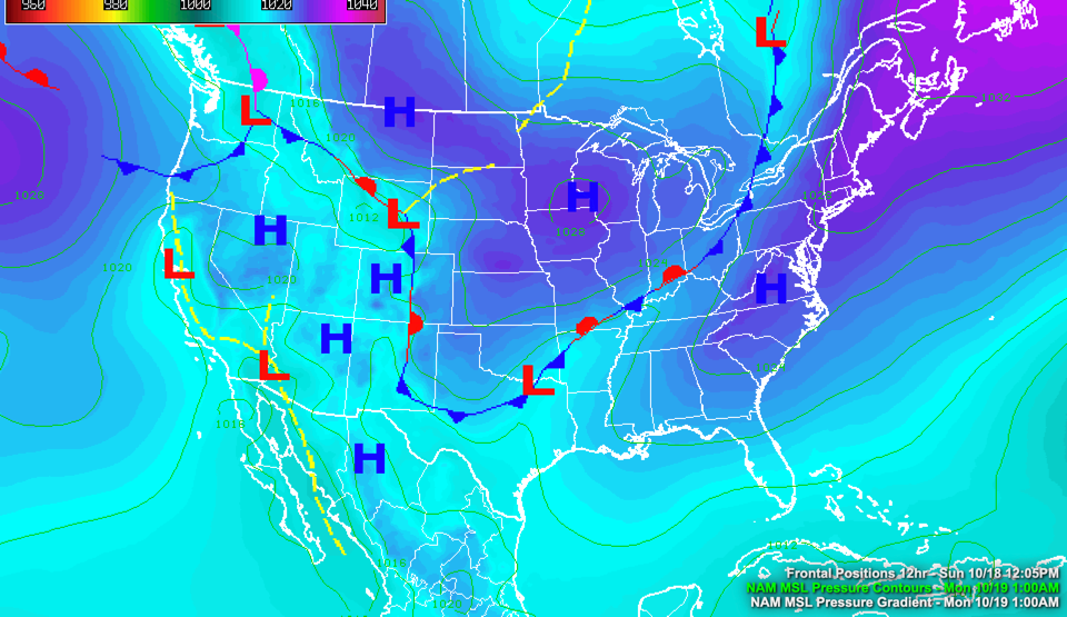
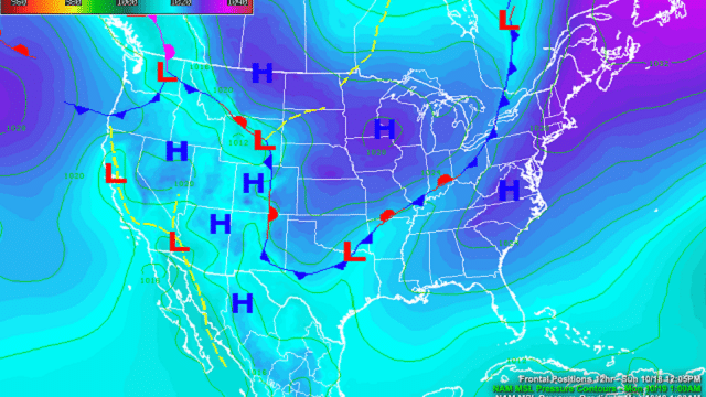
ON THE WEATHER MAPS: Strong high pressure extends along the East Coast from Maine to Alabama this morning. High pressure extends from the Midwest back into the Plains states, with a narrow band of low pressure sandwiched between Kentucky and northeast Texas. A stationary front extends across the low-pressure trough area, accompanied by showers and storms. The front will wash out over the next 36 hours, remaining north of Alabama. The surface high will fill in and remain in control until midweek.
TODAY: We’re starting this morning with mostly sunny to partly cloudy skies and temperatures in the upper 50s. Skies will be mostly sunny today with warm temperatures, in the lower 80s generally. Humidity levels will increase today as southeasterly winds push dewpoints back into the lower 60s. Lows tonight will be in the upper 50s.
THROUGH MIDWEEK: More warm, dry conditions are expected through Thursday as high pressure remains in control. There could be an isolated shower by Thursday afternoon, but chances will be small. Highs will range between 81 and 85 degrees. Morning lows will edge toward the lower 60s. Dewpoints will also climb toward the middle 60s.
WEEKEND OUTLOOK: The western edge of the ridge will erode enough by Friday to allow moisture to surge into Alabama ahead of another approaching front. Showers and storms will develop Friday afternoon and continue into the evening. Showers will linger into Saturday, with a chance of thunder. Rain chances should diminish by Sunday before a stronger front arrives the following Tuesday.
BEACH FORECAST: It is going to be another gorgeous week along the beautiful beaches of Alabama and northwest Florida. Lows will be in the upper 60s, with highs in the lower 80s through midweek along with a good supply of sunshine each day. Showers and storms will return by Friday into the weekend, but it will remain warm. Water temperatures are still in the middle 70s. The rip current risk will be high much of the week.
Click here to see the Beach Forecast Center page.
WEATHERBRAINS: This week the panel was busy, putting two shows in the book in advance of James Spann’s vacation this week. The first featured Penn State researcher Dylan Steinkruger, talking about Artificial Intelligence and tornado warning guidance. The show that will be released tonight features Dr. Mike Farrar, one of the leading weather model experts in the world. Check out the show at www.WeatherBrains.com. You can also subscribe on iTunes. You can watch the show live at live.bigbrainsmedia.com or on James’ YouTube Channel. You will be able to see the show on the James Spann 24×7 weather channel on cable or directly over the air on the dot 2 feed.
ON THIS DATE IN 2005: At 08:01 GMT, Air Force Hurricane Hunters measured a central pressure of 884 millibars in Hurricane Wilma. But the surface pressure when the dropsonde hit the ocean was still 23 knots, so meteorologists knew that the device did not find the true center. The observation was adjusted to 882 millibars, which is the lowest barometric reading ever observed in an Atlantic hurricane. Since the hurricane was intensifying at the time, it is likely that the pressure was even lower. Follow my weather history tweets on Twitter. I am @wxhistorian at Twitter.com.
For more weather news and information from James Spann, Bill Murray and other members of the James Spann team, visit AlabamaWx.