James Spann: Dry tonight, showers Tuesday for Alabama

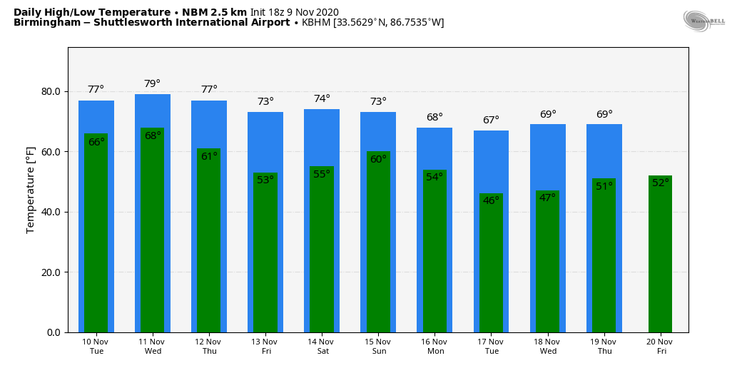
MILD NOVEMBER DAY: Temperatures are mostly between 75 and 79 degrees across Alabama this afternoon with a mix of sun and clouds; the average high for Birmingham on Nov. 9 is 68. There’s no rain on radar, and we stay dry tonight despite the sky becoming mostly cloudy.
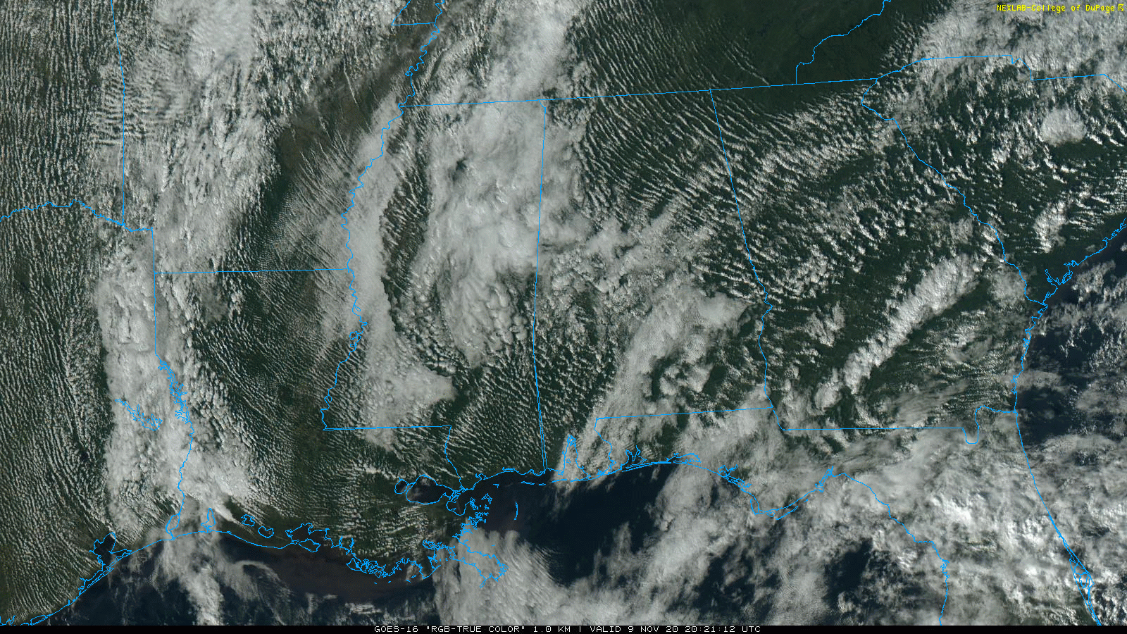
REST OF THE WEEK: Moisture levels will rise Tuesday, and a few showers are possible by afternoon. We will mention a chance of showers statewide Tuesday night and Wednesday ahead of a cold front. There could be a clap of thunder in spots, but severe storms are not expected. Rain amounts will be generally in the one-half-inch range before drier air returns late Wednesday night.
Humidity levels will come down considerably Thursday and Friday with cooler nights in the wake of the front. The sky becomes partly sunny Thursday, and Friday will be partly to mostly sunny. Highs hold in the 70s, but early-morning temperatures will drop into the 48- to 52-degree range by daybreak Friday.
THE ALABAMA WEEKEND: Considerable uncertainty persists in our weekend forecast due to the many possibilities with Tropical Storm Eta in the Gulf of Mexico. Global models show moisture returning late Friday night, and we will need to mention a chance of showers both Saturday and Sunday. I’m not sure I would call it a washout by any means, but if you have something planned outdoors be aware you could be dealing with some rain at times. The sky will be mostly cloudy, and highs will be in the low to mid 70s both days.
NEXT WEEK: Again, forecast confidence is not especially high, but it looks like cooler air will enter the Deep South next week with highs dropping into the 60s and lows in the 40s. Most of the week, for now, looks dry.
TROPICAL STORM ETA: Eta is in the southeast Gulf of Mexico with 50 mph winds; the National Hurricane Center is now expecting the system to remain below hurricane strength over the next five days due to dry air, shear and cooler sea-surface temperatures. The official track takes the system into the Florida Big Bend region, near Cedar Key, Saturday morning.
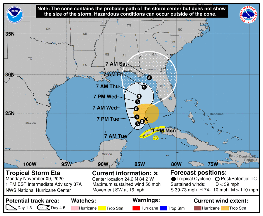
Keep in mind wholesale changes are possible in the NHC forecast as computer model spread remains very high. Solutions range from landfall on the coast of Mexico to the Florida Panhandle, to the system remaining stationary over the Gulf for the next seven days. On the positive side, weakening is likely and the main impact where it comes onshore will be rain. It’s still too early to know what, if any, impact there will be for Alabama or the central Gulf Coast. Hopefully we will get better clarity in coming days.
ELSEWHERE IN THE TROPICS: Shower and thunderstorm activity associated with a low-pressure system several hundred miles southwest of the Azores has increased and become better organized during the past several hours. Satellite-derived wind data this morning suggested that the system had not yet become distinct from a frontal boundary in the area; however, it will likely become non-frontal soon. The satellite data also indicated that the system is already producing gale-force winds. Additional development is expected, and a tropical or subtropical storm will likely form during the next day or two while the system moves eastward or east-northeastward over the northeastern Atlantic Ocean. This will have no impact on the U.S.
A tropical wave is forecast to move over the central Caribbean Sea, where an area of low pressure could form in a couple of days. Environmental conditions are forecast to be conducive for development, and a tropical depression could form late this week or over the weekend while the system moves slowly westward. It’s too early to know whether this will affect the Gulf of Mexico or the U.S.
The 2020 hurricane season ends at the end of this month.
ON THIS DATE IN 1926: An estimated F3 to F4 tornado tore through La Plata, Maryland, killing 14 people at a small school. This storm killed 17 people and injured 65 others.
BEACH FORECAST: Click here to see the AlabamaWx Beach Forecast Center page.
WEATHER BRAINS: You can listen to our weekly 90-minute show anytime on your favorite podcast app. This is the show all about weather featuring many familiar voices, including the meteorologists at ABC 33/40.
CONNECT: You can find me on the major social networks:
For more weather news and information from James Spann and his team, visit AlabamaWx.


