James Spann: Dry day ahead for Alabama; rain returns Wednesday morning
James Spann forecasts dry Tuesday, wet Wednesday for Alabama from Alabama NewsCenter on Vimeo.
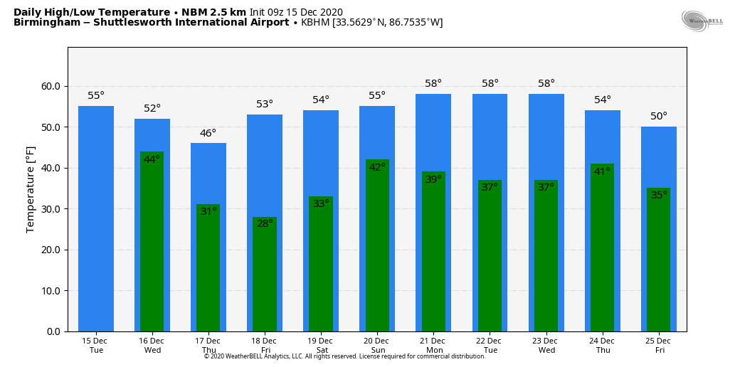
RAIN RETURNS EARLY WEDNESDAY: Today will be dry across Alabama; with a partly sunny sky we expect a high in the mid 50s, right at seasonal values for mid-December. Clouds will increase this afternoon, and an upper trough will push light rain into the state after midnight. The main window for rain comes from about 3 a.m. until noon Wednesday; amounts should be one-half inch or less for most communities, and we are not expecting any thunder with a cool, stable air mass. Many north Alabama communities won’t get out of the 40s.
Thursday and Friday will be dry with a good supply of sunshine both days; the high will be in the upper 40s Thursday, followed by mid 50s Friday. Early morning lows will be below freezing; the coldest morning will come early Friday, with lows well down in the 20s.
THE ALABAMA WEEKEND: Clouds will return to the state Saturday, and a disturbance will bring the chance of some light rain at times. For now, the best chance of rain seems to be late Saturday afternoon, Saturday night and early Sunday. Moisture will be very limited, and rain amounts should be one-quarter inch or less for most places. Highs will be in the mid to upper 50s both days.
CHRISTMAS WEEK: For now, much of next week looks dry with seasonal temperatures — highs mostly in the 50s and lows in the 30s. The reliable European global model does hint at some risk of rain Thursday with a passing cold front, but for now we see no high-impact weather events for Alabama and the Deep South next week.
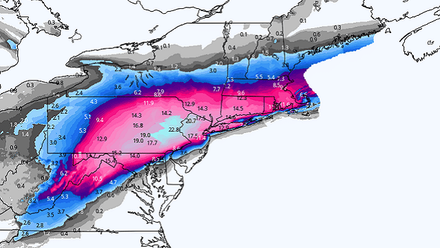
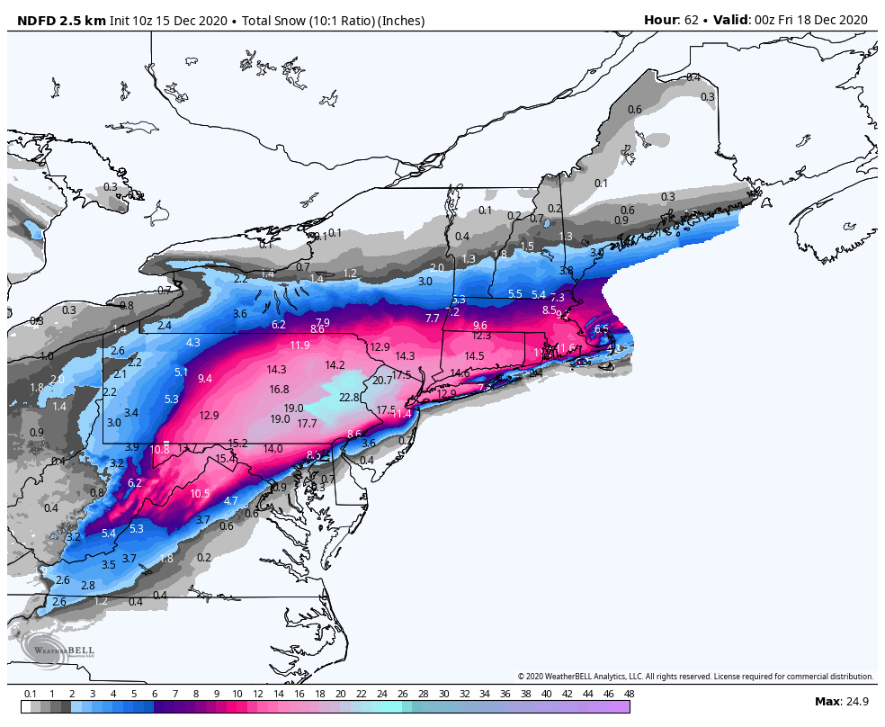
MAJOR EASTERN U.S. SNOW STORM: The system that will bring rain to Alabama Wednesday morning will become a major snow producer as it gains latitude. A high-impact winter storm is likely from parts of Virginia and West Virginia into New England Wednesday through Thursday morning; some spots will see 1 to 2 feet of snow, including New York City.
ON THIS DATE IN 1992: Cyclone John hit the sparsely populated northwest coast of Australia with winds gusting to 185 mph. John was the strongest cyclone to hit Australia in more than 100 years.
BEACH FORECAST: Click here to see the AlabamaWx Beach Forecast Center page.
WEATHER BRAINS: You can listen to our weekly 90-minute show any time on your favorite podcast app. This is the show all about weather featuring many familiar voices, including the meteorologists at ABC 33/40.
CONNECT: You can find me on the major social networks:
For more weather news and information from James Spann and his team, visit AlabamaWx.


