James Spann: Rain moves out of Alabama this morning; dry Thursday, Friday
James Spann has the midweek forecast for Alabama from Alabama NewsCenter on Vimeo.
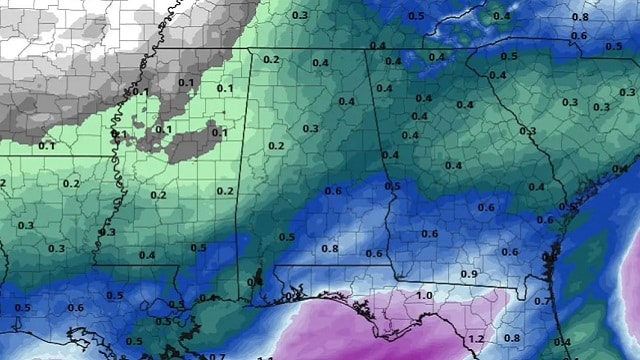
RADAR CHECK: Rain is still fairly widespread over Alabama early this morning, especially the eastern two-thirds of the state. The rain will continue to taper off from west to east over the next few hours as the upper trough moves on to the east. The sky will stay mostly cloudy through the day with temperatures holding in the 40s over the northern half of the state.
The sky will clear early Thursday, and we expect a good supply of sunshine as dry air settles into the Deep South. The high will be in the upper 40s Thursday, followed by mid 50s Friday. Mornings will be cold; we drop into the upper 20s Thursday and mid 20s early Friday.
THE ALABAMA WEEKEND: A disturbance will have the potential to bring a little scattered light rain to Alabama Saturday afternoon, Saturday night and early Sunday, but moisture will be very limited, and rain amounts should be under a quarter of an inch. Otherwise, the weekend will be mostly cloudy with highs in the 50s.
CHRISTMAS WEEK: For now the weather looks dry Monday and Tuesday with highs between 57 and 61 degrees. A cold front will bring a chance of showers Wednesday night or Thursday, followed by dry and sharply colder air on Christmas Day. It doesn’t look like a setup for any significant snow for Alabama, but a few flurries after the cold front passage might be possible at some point Thursday or Thursday night. For now we are forecasting highs in the 40s on Friday, but some north Alabama communities might hold in the 30s. This is still nine days out; expect forecast changes.

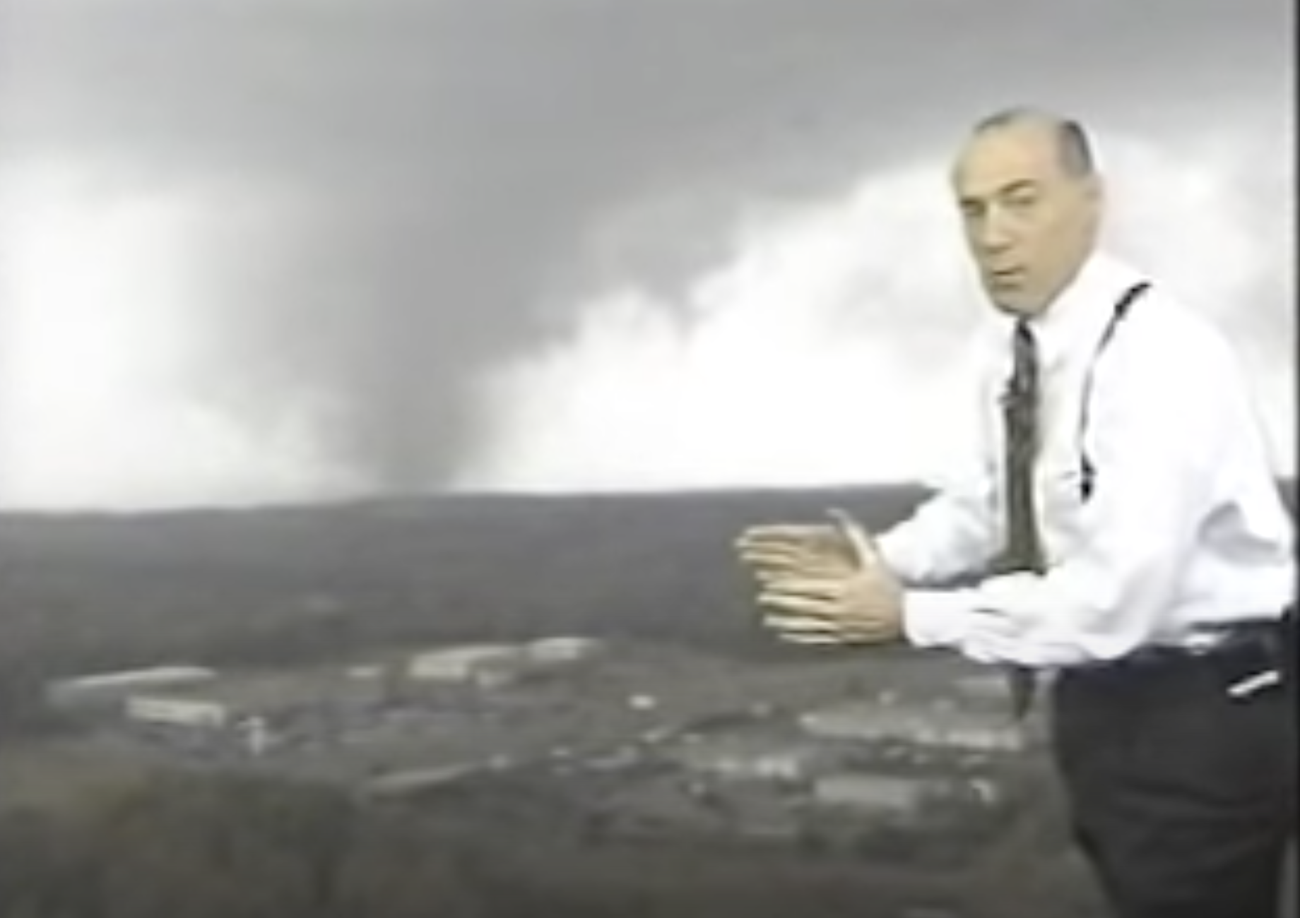
TWENTY YEARS AGO TODAY: An F4 tornado tore through southern Tuscaloosa, killing 11 people and injuring more than 100. Nine of the fatalities occurred in mobile homes, one in a vehicle and one in a commercial building converted to residential use. Six of those killed were females and five were males. Ages ranged from 16 months to 83 years. The tornado was on the ground for 18 miles, all within Tuscaloosa County. The tornado path was estimated to be 750 yards wide at its maximum intensity.
An excellent warning for the tornado was issued at 12:40 p.m. on that deadly Saturday, 14 minutes before the twister first touched down in a rural area southwest of Tuscaloosa near the Black Warrior River. The tornado crossed Alabama 69 near Shelton State Community College and Hillcrest High School, destroying a shopping center and many homes. The Bear Creek Trailer Park was hit, where many of the deaths occurred. The tornado moved to the east/northeast, south of Skyland Boulevard, and finally crossed I-59/20 near the Cottondale exit.
We caught the tornado live on our tower camera in Tuscaloosa; we were able to show live video of the twister on ABC 33/40 for almost 10 minutes as it rolled through the southern part of the city.
Later in the day, the same parent storm dropped an F3 tornado that struck the Coats Bend region of Etowah County, near Gadsden, destroying 250 homes and injuring 14 people.
BEACH FORECAST: Click here to see the AlabamaWx Beach Forecast Center page.
WEATHER BRAINS: You can listen to our weekly 90-minute show any time on your favorite podcast app. This is the show all about weather featuring many familiar voices, including the meteorologists at ABC 33/40.
CONNECT: You can find me on the major social networks:
For more weather news and information from James Spann and his team, visit AlabamaWx.


