James Spann: Alabama stays cool, dry through Wednesday; rain returns Thursday
James Spann forecasts a dry start for the Alabama work week from Alabama NewsCenter on Vimeo.
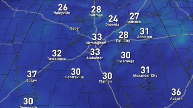
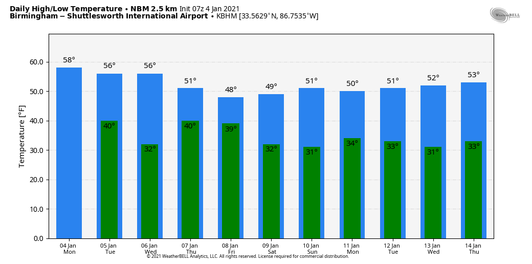
DRY AIR IN PLACE: Temperatures are generally between 24 and 32 degrees across Alabama early this morning; our weather will stay dry today with a high in the upper 50s this afternoon under a partly to mostly sunny sky. The average high for Birmingham on Jan. 4 is 53. Our weather stays rain-free Tuesday and Wednesday; expect a good supply of sunshine both days with highs between 57 and 60 degrees for most communities. Clouds return Wednesday night.
RAIN RETURNS: The next upper wave moving in from the west will bring periods of rain to the state Thursday. There’s no risk of severe storms and probably no thunder. It won’t rain all day, but occasional rain is likely with temperatures holding in the upper 40s and low 50s; rain amounts of around one-half inch are likely. Rain ends late Thursday night and early Friday; we can’t totally rule out a snowflake or two over the Tennessee Valley of far north Alabama due to dynamic cooling, but if that happens there won’t be any accumulation or impact. Look for slow clearing Friday with a high in the upper 40s.
THE ALABAMA WEEKEND: The sky will be partly to mostly sunny Saturday; we start the day in the 20s, and the high will be close to 50 degrees. The day Sunday will be dry with a slow increase in cloud cover; Sunday’s high will be in the mid 50s.
SUNDAY NIGHT/MONDAY: The wave train rolls along, and the next one will bring rain to the state Sunday night into Monday. There is some evidence from global model ensemble output that some snow could be involved initially over north Alabama as the precipitation begins, but for now this is only an outside possibility and thermal values suggest mostly rain for the state. Temperatures will hold in the 40s Monday; for now it looks like the main window for rain will come from about midnight Sunday night through noon Monday. This, of course, is a week out and the forecast could easily change.
REST OF NEXT WEEK: Cool, dry weather is likely for midweek before more rain returns either Thursday or Friday.
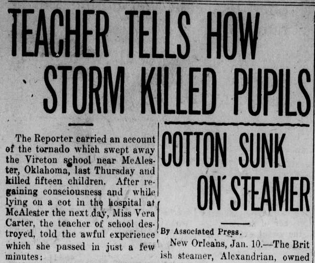
ON THIS DATE IN 1917: A tornado with estimated F-3 damage cut a 15-mile path and struck a school at Vireton in Pittsburg County, Oklahoma, killing 16 people. It ranks as the fourth-worst school tornado disaster in U.S. history. Ahead of that storm system, very warm air surged into the Southeast. Birmingham’s high on Jan. 4, 1917, was 75 degrees, a record for the date that still stands.
BEACH FORECAST: Click here to see the AlabamaWx Beach Forecast Center page.
WEATHER BRAINS: You can listen to our weekly 90-minute show any time on your favorite podcast app. This is the show all about weather featuring many familiar voices, including the meteorologists at ABC 33/40.
CONNECT: You can find me on the major social networks:
For more weather news and information from James Spann and his team, visit AlabamaWx.com.


