James Spann: Rain returns Thursday; snow for Alabama Sunday night/Monday?
James Spann forecasts dry weather for Alabama through midweek from Alabama NewsCenter on Vimeo.
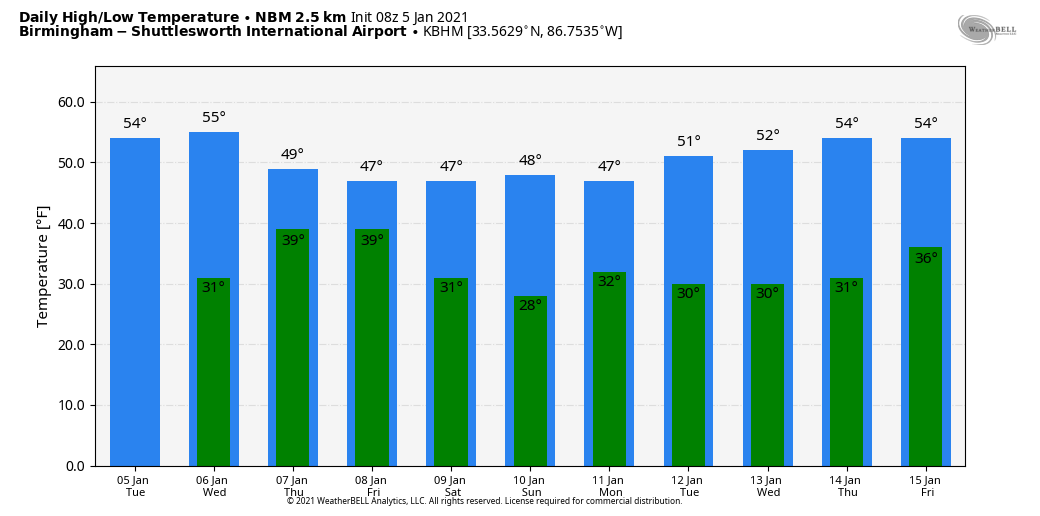
DRY THROUGH WEDNESDAY: As the day begins, a dense fog advisory is in effect for parts of est and southwest Alabama; that fog should dissipate by midmorning. Otherwise, today will be mostly sunny with a high in the mid 50s this afternoon; the average high for Birmingham on Jan. 5 is 53. Tonight will be clear and cold; temperatures by daybreak Wednesday will drop into the 27- to 32-degree range. During the day Wednesday expect a partly to mostly sunny sky with a high in the mid to upper 50s.
RAIN RETURNS: Clouds move in Wednesday night, and Thursday will be a very cool, wet day. Look for occasional rain with temperatures holding in the 40s all day — no severe storms, no thunder, and rain amounts should be one-quarter to one-half inch for most communities. Light rain will linger into Thursday night as a deep, cold-core upper low moves overhead. These systems can sometimes bring dynamic cooling and unexpected snowflakes, but for now all thermal values suggest just some cold rain for Alabama.
Rain ends early Friday, followed by gradual clearing. Friday’s high will be somewhere between 46 and 51 degrees.
THE ALABAMA WEEKEND: Saturday will be mostly sunny; after a low in the 20s, the high will be close to 50 degrees. Sunday will be dry and cool, with a high in the 40s; clouds will increase late in the day ahead of the next storm system to the west.
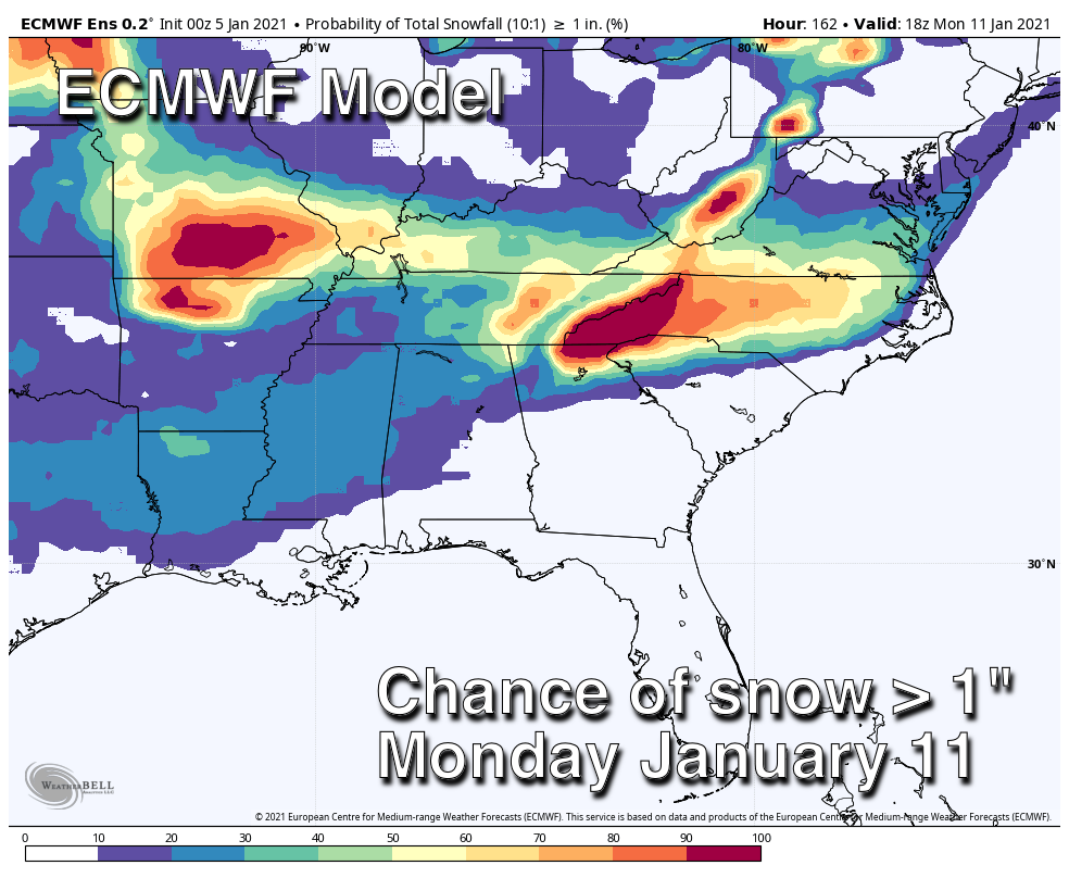
SNOW? You will see snow maps plastered all over social media (mostly from people who don’t have a fundamental idea of how numerical weather prediction actually works) about the system that will impact Alabama Sunday night into Monday. Looking at deterministic model output for a system this far out really isn’t productive; it is best to use ensemble model output and probabilistic forecasts.
An ensemble is a set of forecasts that present the range of future weather possibilities. Multiple simulations are run, each with a slight variation of its initial conditions and with slightly perturbed weather models. These variations represent the inevitable uncertainty in the initial conditions and approximations in the models. They produce a range of possible weather conditions.
For now, the American model (the GFS) suggests the chance of snow greater than 1 inch for north Alabama is 10-20%; the European ensemble is a bit more aggressive with 20-30% probabilities. There is no way now to resolve specific details and provide a meaningful forecast; it is just something to watch. This system could bring a significant winter storm to parts of the Deep South, or just a cold rain. We will begin to have a good idea of what to expect late this week.
REST OF NEXT WEEK: After the system moves out Monday evening, the weather looks cool and dry for the middle of next week; some rain could return by Friday, Jan. 15.
ON THIS DATE IN 1962: Two tornadoes, about 100 yards apart and each making paths about 100 yards wide, followed parallel paths from southeast to northwest through the edge of the Crestview, Florida, residential area. These tornadoes killed one and injured 30 others.
BEACH FORECAST: Click here to see the AlabamaWx Beach Forecast Center page.
WEATHER BRAINS: You can listen to our weekly 90-minute show any time on your favorite podcast app. This is the show all about weather featuring many familiar voices, including the meteorologists at ABC 33/40.
CONNECT: You can find me on the major social networks:
For more weather news and information from James Spann and his team, visit AlabamaWx.com.