James Spann: Strong to severe storms possible in Alabama tonight
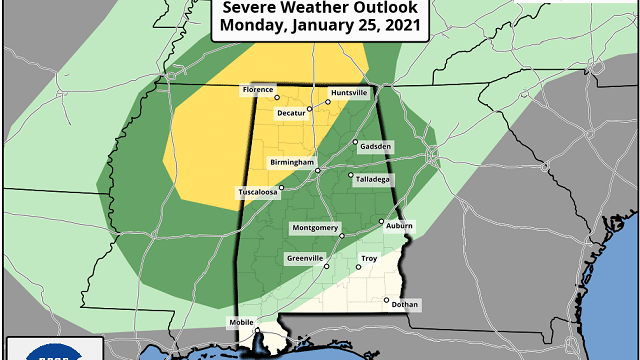
ACTIVE NIGHT AHEAD: Most of Alabama is enjoying a spring-like day today with temperatures in the 70s; a few spots in west Alabama are flirting with 80 degrees. The exception is the northeast corner of the state, where a wedge of cooler air is still in place. A cold front will slice into the state tonight, and the risk of severe storms has increased based on the latest model data. The Storm Prediction Center has introduced a slight risk (level 2 of 5) for areas north of a line from Northport to Warrior to Guntersville, and a marginal risk (level 1 of 5) extends as far south as Jackson, Fort Deposit and Opelika.
A few storms tonight across the northern two-thirds of Alabama could produce hail and strong winds; an isolated tornado or two is possible as well. The main window for severe storms is from 7 this evening until 2 a.m. Tuesday. Be sure you can hear severe weather warnings if they are needed tonight.
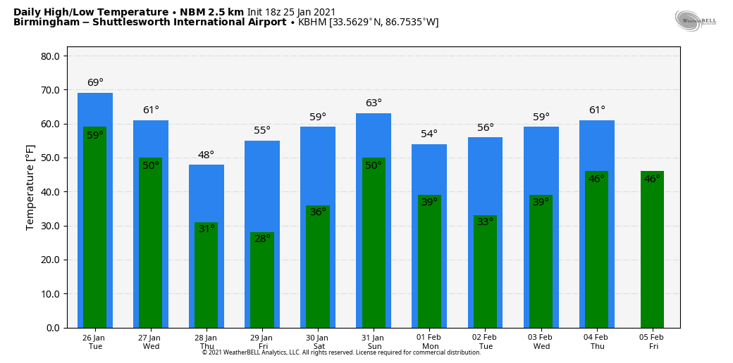
TUESDAY/WEDNESDAY: The front will stall out Tuesday close to a line from Grove Hill to Montgomery to Lafayette; rain is still possible south of the front. The northern half of the state will be mostly dry; a few peeks of sun are possible with temperatures rising near 70 degrees by afternoon. Then, a wave forms on the stalled front and rain is likely statewide Tuesday night into Wednesday. Additional rain amounts of one-half to 1 inch are likely; severe storms are not expected.
Temperatures could very well fall during the day Wednesday over north Alabama, and some snow is possible over parts of Tennessee in the colder air there.
THURSDAY/FRIDAY: Thursday will be mostly sunny but much colder, with a high between 48 and 52. We drop well down into the 20s early Friday morning with a clear sky and light wind; then the sky will remain sunny during the day Friday with a high in the mid 50s.
THE ALABAMA WEEKEND: Saturday looks dry with a partly sunny sky; the high will be close to 60. Then, the next weather system will bring rain into the state Saturday night into Sunday; for now it looks like the main window for rain comes from about midnight until noon. Sunday’s high will be in the mid to upper 50s.
NEXT WEEK: The weather looks dry with seasonal temperatures for the first half of the week (highs in the 50s, lows in the 30s), but rain returns Thursday night or Friday.
ON THIS DATE IN 1940: In the morning, the headlines on the Birmingham Age-Herald screamed that more cold was in store for the state. And it had already been very cold. Since an Arctic cold wave invaded the state on the night of Jan. 18, overnight lows had been in the teens or single digits every morning except for Jan. 23, when the low was 24. The average temperature of 21.3 for the seven-day period ending Jan. 25 stands as the ninth-coldest seven-day period in Birmingham history.
The 1940 cold wave still holds most of the cold-wave records in Magic City history, including seven of the 10 coldest seven-day periods, the three coldest 10-day periods as well as seven of the top 10 coldest 10-day periods and the top nine coldest 14-day periods.
BEACH FORECAST: Click here to see the AlabamaWx Beach Forecast Center page.
WEATHER BRAINS: You can listen to our weekly 90-minute show anytime on your favorite podcast app. This is the show all about weather featuring many familiar voices, including the meteorologists at ABC 33/40.
CONNECT: You can find me on the major social networks:
For more weather news and information from James Spann and his team, visit AlabamaWx.


