James Spann: Cloudy, windy, cold day for Alabama with a few flurries
James Spann forecasts a cold start for the Alabama work week from Alabama NewsCenter on Vimeo.
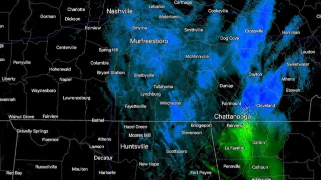
COLD AIR RETURNS: Parts of Alabama enjoyed 70-degree warmth Sunday, but cold air returned last night, and today will be a raw winter day for the state. Clouds linger through the day with an icy northwest wind of 15-25 mph. A few snow flurries or showers are likely over the northern counties today, but no impact is expected. Where heavier snow showers develop, a few higher-terrain locations across the northeast corner of the state could see the ground become white, but even there we are not expecting travel issues.
Temperatures won’t change much all day. They hold in the 30s over the Tennessee Valley; the high for places like Tuscaloosa, Birmingham, Anniston and Gadsden will be around 40. South Alabama will see a high in the mid to upper 40s today.
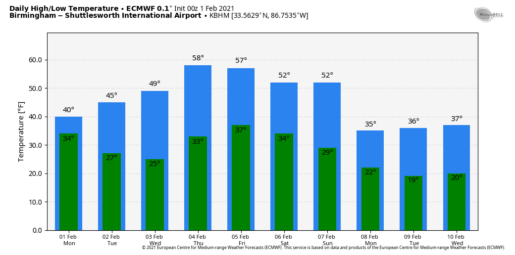
The sky will clear tonight, and we drop into the 20s early Tuesday morning. During the day Tuesday, the high will be in the 45- to 50-degree range with a good supply of sunshine. Wednesday will be sunny with a high between 50 and 55.
RAIN RETURNS: Thursday will be dry with a high close to 60 degrees, but clouds will increase by afternoon ahead of a cold front. That front will bring rain to the state late Thursday night into Friday morning. Amounts should be one-half inch or less, and severe storms are not expected. Friday will be cloudy and colder with a high around 50.
FRIDAY NIGHT: Model madness makes for a low-confidence forecast. The American GFS global model shows a wave of low pressure forming on the front, which will be over far south Alabama, and suggests a chance of snow for north Alabama. However, the reliable European global model says “meh” and doesn’t develop the wave, keeping just a chance of some light rain over south Alabama. For now we will side with the dry solution for north Alabama, but obviously watch for model trends in coming days.
THE ALABAMA WEEKEND: Saturday will be mostly cloudy and colder with a high in the 40s; some rain is likely for the southern half of the state around the stalled front. The coldest air so far this season begins to arrive Sunday as temperatures will fall into the 30s over north and central Alabama with a strong northwest wind.
COLDEST SO FAR: There is a high probability we will see temperatures in the teens Monday morning (one week from today) with a clear sky. It’s a little too early for a specific forecast, but for now it looks like we will see lows in the 10- to 20-degree range. Monday will be sunny with a high between 35 and 42.
REST OF NEXT WEEK: Clouds return Tuesday, and there will be some risk of precipitation by Tuesday night into Wednesday. At the moment it looks like thermal values favor rain for most of the state, but this is eight days out and things could easily change. The latter half of the week looks dry with a warming trend.
ON THIS DATE IN 1955: Seen first as a “well-defined cone-shaped funnel” over the Mississippi River, an F3 tornado cut a path from Commerce Landing to Clark in northwest Mississippi.
ON THIS DATE IN 1996: Very cold Arctic air covered Alabama, and an “overrunning” precipitation event started that night, the beginning of a significant ice storm for many places. A period of freezing rain followed by light snow brought traffic to a complete standstill across north Alabama. Ice accumulations up to 1 inch downed numerous trees and caused power outages. A number of chicken houses in the northern part of the state collapsed under the weight of the ice and snow. Accumulations varied widely, with some of the highest amounts reported in the 1- to 3-inch range.
BEACH FORECAST: Click here to see the AlabamaWx Beach Forecast Center page.
WEATHER BRAINS: You can listen to our weekly 90-minute show anytime on your favorite podcast app. This is the show all about weather featuring many familiar voices, including the meteorologists at ABC 33/40.
CONNECT: You can find me on all of the major social networks:
For more weather news and information from James Spann and his team, visit AlabamaWx.


