James Spann: Clouds linger over Alabama; drizzle, flurries possible
James Spann forecasts calmer weather for Alabama from Alabama NewsCenter on Vimeo.
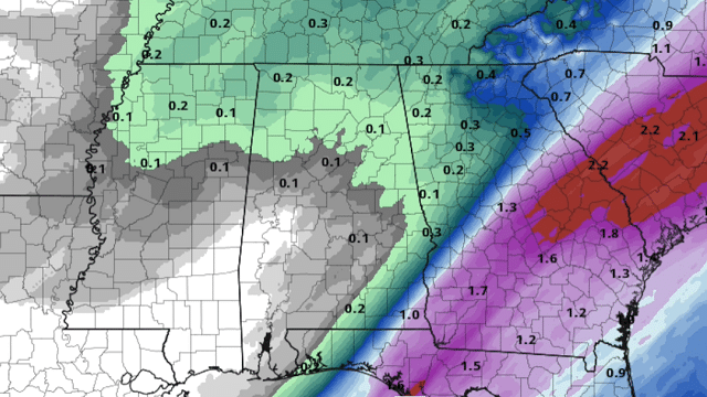
CALMING DOWN: The big mass of precipitation that brought rain, sleet and snow to Alabama last night has mostly moved out of the state. The exception is the southeast corner of the state, where a Tornado Watch remains in effect for Geneva and Houston counties until 8 a.m. Storms there will be over by midmorning.
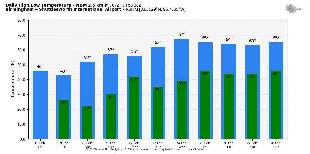
Today will be cloudy and cold over the northern half of the state, with temperatures holding in the mid to upper 30s north of U.S. 278, 40s for the central counties and 50s to the south. The day will be mostly dry, although some patchy drizzle is possible. A few snow flurries are possible this afternoon and tonight down to I-20, but no impact is expected.
FRIDAY AND THE WEEKEND: Morning clouds will give way to a mostly sunny afternoon Friday; highs will be in the 30s over the northern quarter of the state, 40s for central Alabama and 50s over the southern counties. Saturday morning will feature a significant freeze, with a low between 16 and 24 degrees. Then a welcomed warming trend begins. Look for a good supply of sunshine Saturday and Sunday with a high in the mid 50s Saturday, followed by low 60s Sunday.
NEXT WEEK: A disturbance could bring a few light showers to the state Monday morning; otherwise most of the week looks dry and mild, with highs in the 60s and lows mostly in the upper 30s and 40s. Some light rain is possible Friday, Feb. 25, but we see no high-impact events for the state for the next seven to 10 days as the pattern looks much calmer.
LAST NIGHT’S SNOW: Snow amounts of 2-5 inches were reported across northwest Alabama counties like Madison, Limestone, Morgan, Lauderdale, Colbert, Lawrence, Marion and Winston. In some places the snow changed to rain, washing some of the snow away.
ON THIS DATE IN 1992: A thunderstorm spawned an unusually strong F4 tornado for so far north this time of the year in southern Van Wert County in Ohio. The tornado touched down just west of U.S. Route 127 and traveled northeast for about 3 miles. One house was completely leveled and nine others sustained severe damage. Six people were injured.
ON THIS DATE IN 2009: A long-lived supercell thunderstorm moved from Sumter County east to Montgomery County. Damage along the path was the result of straight-line winds; localized areas received winds up to 70 mph. Minor to moderate damage was discovered in Sumter, Greene, Hale, Perry and Dallas counties. The damage was generally confined to shallow-rooted trees and weaker structures. The storm also produced a swath of hail that covered the ground in many places and was golf ball to baseball size.
BEACH FORECAST: Click here to see the AlabamaWx Beach Forecast Center page.
WEATHER BRAINS: You can listen to our weekly 90-minute show anytime on your favorite podcast app. This is the show all about weather featuring many familiar voices, including the meteorologists at ABC 33/40.
CONNECT: You can find me on the major social networks:
For more weather news and information from James Spann and his team, visit AlabamaWx.


