James Spann: Rain for north Alabama this morning; warm weekend ahead
James Spann has the Alabama forecast to wrap up the work week from Alabama NewsCenter on Vimeo.
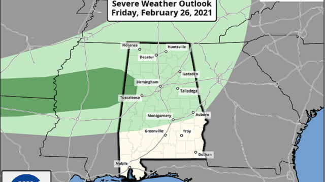
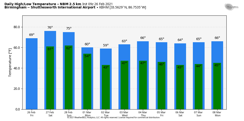
RADAR CHECK: Rain is widespread early this morning north of I-20, over the northern third of the state. The rain will slowly diminish later this morning, and by afternoon most of the state will be dry with showers near and north of the Tennessee River. Some thunder is possible today, but odds of severe storms are very low, and the Storm Prediction Center has dropped the marginal risk for most of the state. The day will be mostly cloudy with temperatures in the 50s over the Tennessee Valley, and 60s and low 70s for the rest of the state.
THE ALABAMA WEEKEND: It looks like the warmest weekend so far this year, with highs between 75 and 80 degrees. The sky will be generally cloudy Saturday and Sunday, but the sun could very well peek out at times. A few isolated showers can’t be ruled out, especially over the Tennessee Valley, but most of the weekend will be dry as the surface front will be up near the Tennessee state line. Heavy rain is possible for parts of Arkansas and Tennessee, north of the front.
NEXT WEEK: The front will drift southward early in the week, and periods of rain and a few thunderstorms are likely Monday through Tuesday night. The European global model continues to hint that strong storms are a possibility by Tuesday evening, but it is too early to determine whether there will be a significant severe weather threat. Rain could be heavy at times, with totals of 2-4 inches possible. Dry air begins to return Wednesday, and for now we expect dry weather Thursday and Friday. Highs through the week will be mostly in the 60s, and we still see no sign of any subfreezing lows for the next seven to 10 days across Alabama.
ON THIS DATE IN 1972: The Buffalo Creek disaster occurred in the Buffalo Creek Hollow of Logan County in West Virginia. A coal slag dam on the Middle Fork of Buffalo Creek burst, sending a 50-foot wall of water down a narrow valley, killing 125 people and causing $51 million damage. Three days of rain atop a 6-inch snow cover caused the dam to break.
ON THIS DATE IN 2008: Three EF-1 tornadoes touched down across parts of Jefferson, Shelby and St. Clair counties before dawn. Straight-line wind damage was reported across parts of east Alabama as well.
BEACH FORECAST: Click here to see the AlabamaWx Beach Forecast Center page.
WEATHER BRAINS: You can listen to our weekly 90-minute show any time on your favorite podcast app. This is the show all about weather featuring many familiar voices, including the meteorologists at ABC 33/40.
CONNECT: You can find me on the major social networks:
For more weather news and information from James Spann and his team, visit AlabamaWx.


