James Spann: Cold, wet Tuesday for Alabama; drier Wednesday
James Spann forecasts a cold, rainy Tuesday in Alabama from Alabama NewsCenter on Vimeo.
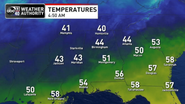
WET IS THE WORD: A well-defined upper-air short wave will bring occasional rain to Alabama today. Amounts of one-half inch are likely for the northern half of the state; some spots in south Alabama will see more than 1 inch. The air will be cold and stable; most north Alabama communities will hold in the 40s all day, meaning no risk of severe storms and probably no thunder. The rain will end from the west tonight.
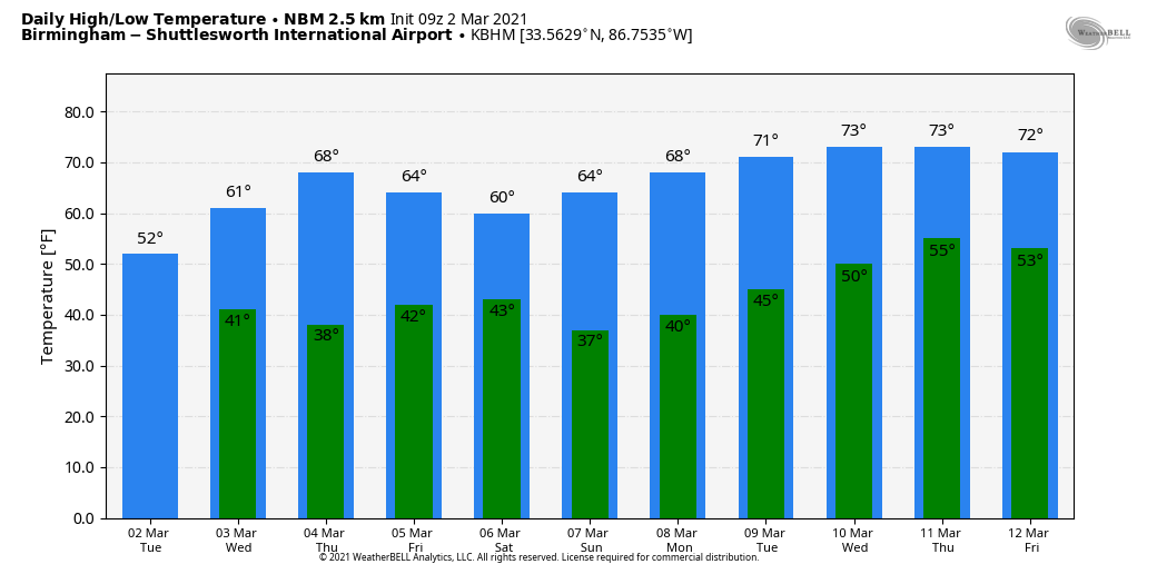
REST OF THE WEEK: Wednesday will be brighter and warmer; the sky becomes partly to mostly sunny with a high in the low 60s. Thursday will feature sun in full supply with a high between 66 and 70 degrees. Friday will be dry with a high in the upper 60s, but clouds will increase by afternoon ahead of a disturbance that could squeeze out some light rain across the southern two-thirds of the state Friday night.
THE ALABAMA WEEKEND: Some patchy, light rain is possible Saturday morning, followed by gradual clearing Saturday afternoon. Sunday will be a bright, sunny day as dry air settles into the state. The high will be in the low 60s Saturday, followed by mid 60s Sunday — very close to seasonal averages for early March in Alabama.
NEXT WEEK: The week looks fairly quiet. Moisture levels rise a bit over the latter half of the week with some risk of scattered showers, but for now we are not expecting any major or widespread rain event. Highs will be in the 60s Monday and close to 70 Tuesday, followed by low to mid 70s over the latter half of the week.
ON THIS DATE IN 2012: Twelve tornadoes touched down in Alabama, including one EF-2 in Tallapoosa and Chambers counties that killed one person. This large multiple-vortex tornado crossed Lake Martin near the beginning of its path before passing near Jackson’s Gap, Eagle Creek and Trammel Crossroads. Several homes sustained significant damage and multiple mobile homes were destroyed. One mobile home frame was wrapped completely around a tree trunk. Thousands of trees were snapped and uprooted along the path.
In the Tennessee Valley, an EF-3 tornado tore through parts of Limestone and Madison counties. This tornado first moved through multiple subdivisions near Athens, with roofs torn off homes, windows and garage doors blown out, exterior walls damaged and garages collapsed. The tornado then caused major roof and exterior wall damage to homes in and around Harvest. Homes at the north edge of Meridianville had their roofs torn off, a metal shed was severely damaged, a concrete power pole was snapped and buildings at Meridianville Middle School sustained roof damage. The most intense damage occurred near Hazel Green, where several homes had roofs torn off and walls collapsed, and three were reduced to rubble.
BEACH FORECAST: Click here to see the AlabamaWx Beach Forecast Center page.
WEATHER BRAINS: You can listen to our weekly 90-minute show any time on your favorite podcast app. This is the show all about weather featuring many familiar voices, including the meteorologists at ABC 33/40.
CONNECT: You can find me on the major social networks:
For more weather news and information from James Spann and his team, visit AlabamaWx.


