Scott Martin: Dry with warming temperatures through the Alabama weekend
THE ALABAMA WEEKEND: The good news is that we’ll continue to dry out today from the copious amount of rain received throughout this past week. Skies will be clearing throughout the day and we’ll end up mainly sunny by sunset. Highs will make it into the upper 50s to the mid-60s from east to west. Skies will be mainly clear tonight with lows dipping into the mid-30s to the lower 40s.
Sunday will feature plenty of sunshine with only a few clouds. High pressure will be stationed to our northeast, and that will pull warmer air up from the south. Afternoon highs will range from the lower 60s in the northwest to the upper 60s in the southeast.
NEXT WEEK: Monday will be dry. We’ll continue to have a good bit of sunshine throughout the day with one or two clouds. Warm air will continue to flow up from the south and highs will make it into the upper 60s to the lower 70s.
A system will move into the state Tuesday that will bring showers and a thunderstorm or two with it. At this point, the dynamics look to be too far north to cause any strong to severe storms. Afternoon highs will be in the mid-60s to the mid-70s.
Rain and a few storms will be possible throughout the day Wednesday. We may have a few breaks where we could see a few minutes of sunshine during the late afternoon before more clouds and rain move in for the evening. Highs will be in the upper 60s to the mid-70s.
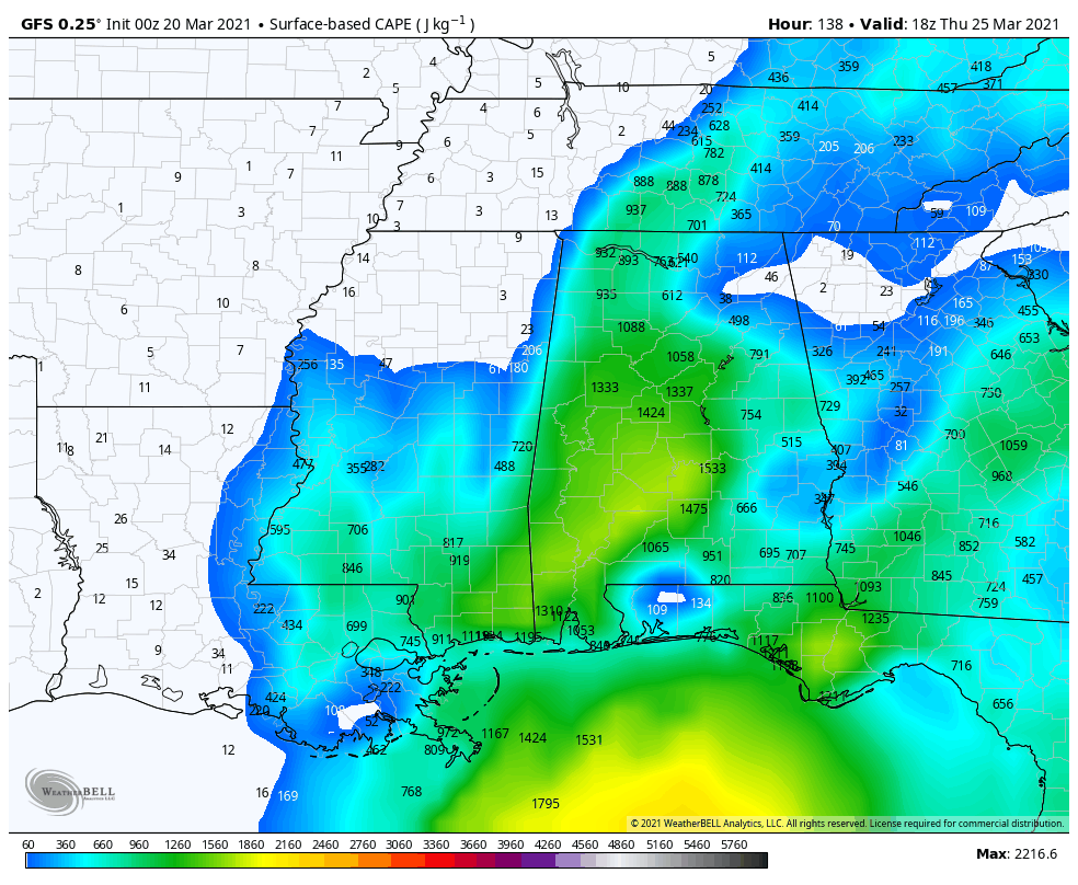
On Thursday, a surface low will form to our southwest and move through northwestern Alabama during the late-night and into the overnight hours. Out ahead of the low, rain and thunderstorms will move across the state throughout the day, with heavy rain possible during the evening and late night. There will be a decent bit of instability, so we may have to watch for a few strong to possibly severe storms, but we are too far out to be specific at this point. We are in the middle of the most active part of our severe weather season in Alabama, so we’ll have to watch nearly every system that moves through. Highs will be in the upper 60s to the upper 70s.
Showers and storms will move out during the early morning Friday, with skies becoming mostly sunny by the afternoon. Highs will range from the lower 70s in the northwest to the upper 70s in the southeast.
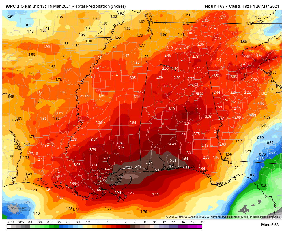
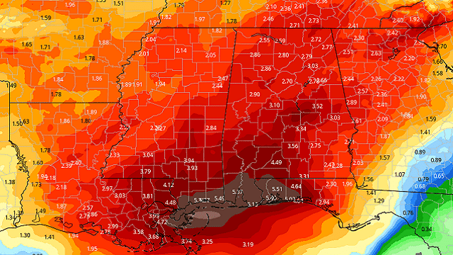
PROJECTED RAINFALL AMOUNTS: The latest projected rainfall totals from the Weather Prediction Center over the next seven days for north and central Alabama range from as low as 2 inches to as high as 4 inches, with the higher totals occurring over the south-central and east-central parts of the area, much of that occurring Thursday.
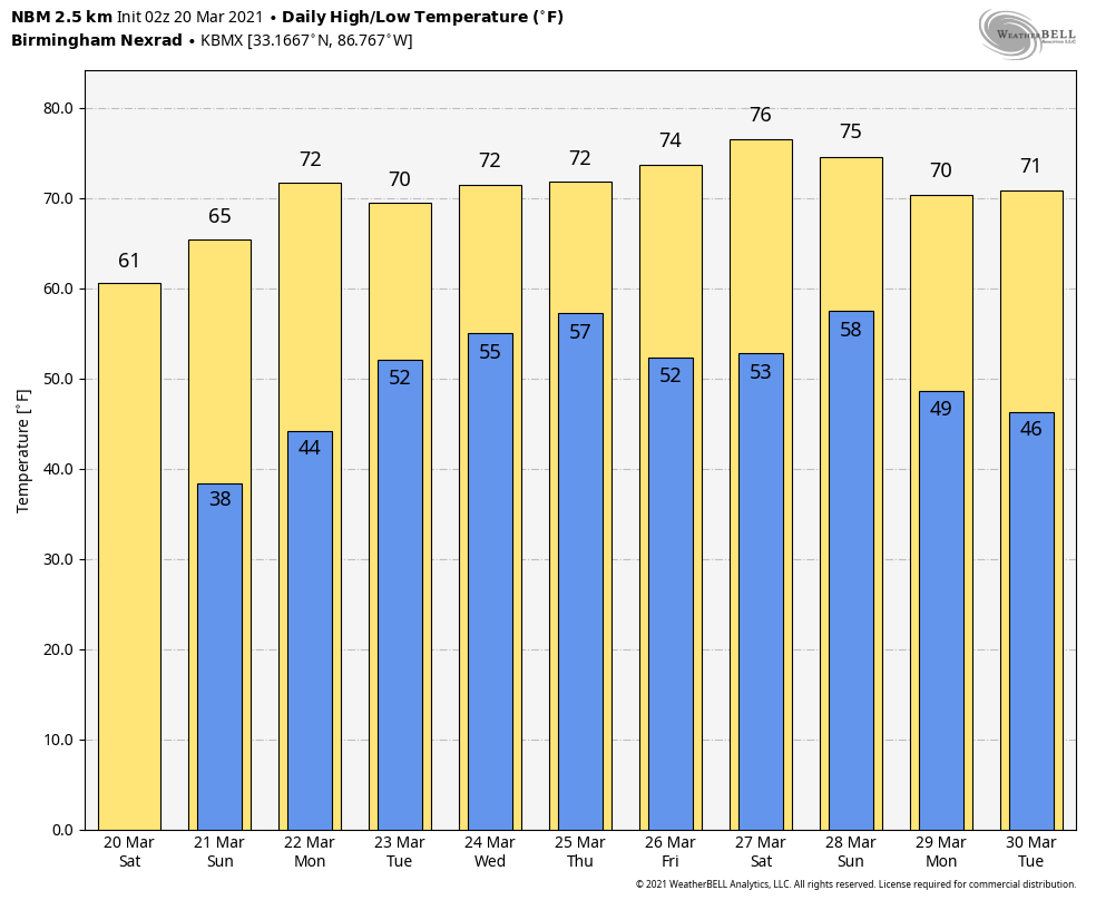
VOODOO LAND: After we hit the 70s on Friday, highs look to stay in the upper 60s to the upper 70s through the end of the month. Lows will stay above the freezing mark, ranging from the lower 40s to the lower 60s.
ON THIS DAY IN 1989: Snow and high winds created blizzard conditions in western Kansas to usher in the official start of spring. Thunderstorms produced severe weather from east Texas to Alabama and northwest Florida, with nearly 50 reports of large hail and damaging winds during the afternoon and evening.
BEACH FORECAST CENTER: Get the latest weather and rip current forecasts for the beaches from Dauphin Island to Panama City Beach, Florida, on our Beach Forecast Center page. There, you can select the forecast of the region you are interested in.
For more weather news and information from James Spann, Scott Martin and other members of the James Spann team, visit AlabamaWx.


