James Spann: Rain, strong storms for Alabama, then much colder
James Spann: More rain and storms for Alabama today followed by much colder temperatures from Alabama NewsCenter on Vimeo.
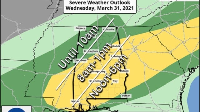
ACTIVE DAY: A cold front will push a band of showers and thunderstorms through Alabama today. The Storm Prediction Center has defined a slight risk (level 2 out of 5) of severe thunderstorms for areas along and south of I-59 (Tuscaloosa, Birmingham, Gadsden and points south), with a marginal risk (level 1 of 5) for areas north of Birmingham.
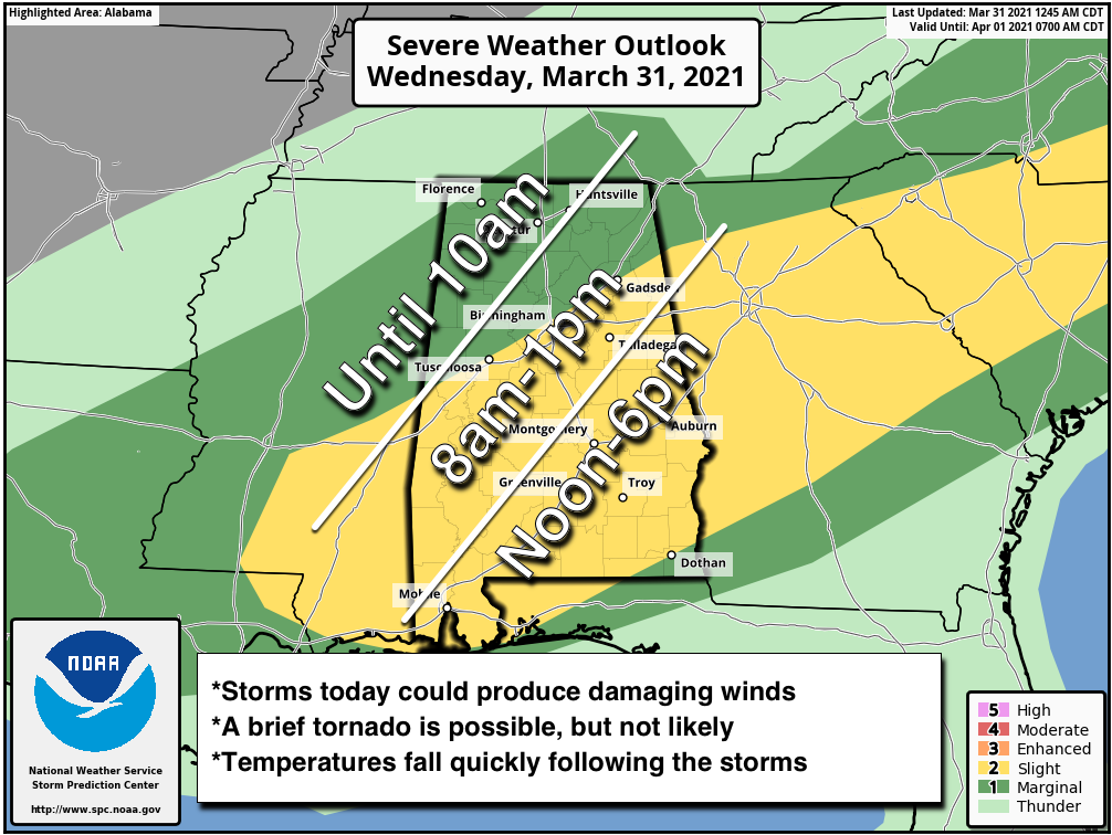
TIMING: The main line of storms should reach I-59 (including the Birmingham metro) between 10 a.m. and noon, Montgomery around 4-5 p.m. and Dothan by 8 p.m.
THREATS: The main threat will come from strong, potentially damaging straight-line winds. With the ground saturated, it won’t take much to knock down some trees. An isolated, brief tornado is possible, but not likely. Some small hail is possible as well.
FLOODING: A Flash Flood Watch is in effect for areas north of a line from Millport to Fayette to Birmingham to Ranburne. Rain amounts could approach 2 inches in spots.
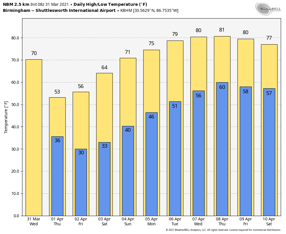
FALLING TEMPERATURES: After the heavier storms pass through, temperatures will fall quickly through the 50s and into the upper 40s. For some places, it will be a 25-degree drop over a short amount of time. A gusty northwest wind will make it feel colder. Be ready for the change today.
LATE-SEASON FREEZE: The sky will clear tonight and temperatures will drop into the low 30s Thursday morning. Friday morning will be colder as the winds will be near calm; temperatures will be between 22 and 29 degrees for much of north and central Alabama. Another freeze is possible Saturday morning, with lows between 28 and 32 for most places. Growers beware.
Thursday will be sunny, but windy and very cool, with a high between 55 and 59 degrees. Sunny weather continues Friday; the day won’t be as windy and the high will be in the upper 50s. The sky will stay sunny over the weekend with a warming trend. We reach the upper 60s Saturday and low 70s on Easter.
NEXT WEEK: Dry weather continues for the first half of next week, and temperatures will be close to 80 degrees by Tuesday and Wednesday. Showers return Thursday or Friday, and for now it doesn’t look like a severe weather setup.
ON THIS DATE IN 1973: A devastating tornado took a nearly continuous 75-mile path through north-central Georgia, causing more than $104 million damage. The tornado first touched down near Jonesboro around 5:30 p.m. and carved a 75-mile-long path through Clayton, Henry, Dekalb, Rockdale, Walton, Oconee, Clarke and Oglethorpe counties before finally dissipating 10 miles east-northeast of Athens. Two were killed, one near Conyers and one in Athens. An even stronger tornado (F-4) was spawned from the parent supercell and killed seven along a path from Calhoun Falls to Abbeville, South Carolina.
ON THIS DATE ONE YEAR AGO: Four tornadoes touched down across the Southeast, including an EF-2 that moved through southern Eufaula. The most significant damage occurred in the Country Club of Alabama neighborhood along the south side of Pebble Beach Drive. The tornado crossed the Walter F. George Reservoir along the Chattahoochee River and continued into Quitman County in Georgia.
BEACH FORECAST: Click here to see the AlabamaWx Beach Forecast Center page.
WEATHER BRAINS: You can listen to our weekly 90-minute show any time on your favorite podcast app. This is the show all about weather featuring many familiar voices, including the meteorologists at ABC 33/40.
CONNECT: You can find me on the major social networks:
For more weather news and information from James Spann and his team, visit AlabamaWx.


