James Spann: Windy, much cooler in Alabama today; some frost early Thursday
James Spann has a cool midweek forecast for Alabama from Alabama NewsCenter on Vimeo.
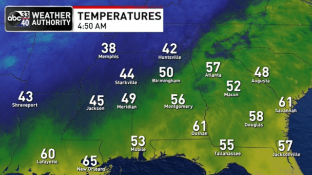
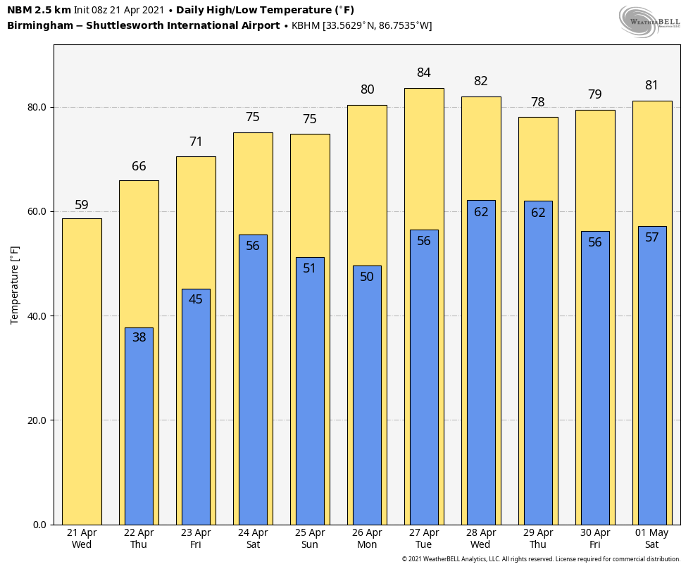
COLD FRONT PASSING THROUGH: A sharp cold front is passing through Alabama early this morning. We note a few sprinkles over the Tennessee Valley, but for most places there will be no rain. The big story is the colder air; the day ahead will be windy and very cool, with a high only in the 55- to 60-degree range. A brisk northwest wind of 12-25 mph will make it feel colder despite sunshine in full supply. The wind will die down tonight, and with a clear sky temperatures will drop quickly. Most communities will wind up somewhere between 33 and 40 degrees early Thursday morning.
Frost is likely in many areas over the northern half of the state, and a few of the traditionally colder spots (places like Valley Head and Black Creek) could briefly touch the freezing mark — a classic case of “blackberry winter,” as some call it. During the day Thursday, the sky will be sunny with a high in the mid 60s.
The weather stays dry during the day Friday; with a partly sunny sky the afternoon high will be somewhere between 65 and 70 degrees. Clouds thicken Friday night.
STORMY SATURDAY: Rain and storms are likely in the general window from midnight Friday night through 6 p.m. Saturday. There will be breaks in the rain, but this will be a statewide soaking with amounts of 1 to 2 inches likely. Some flooding could develop in spots.
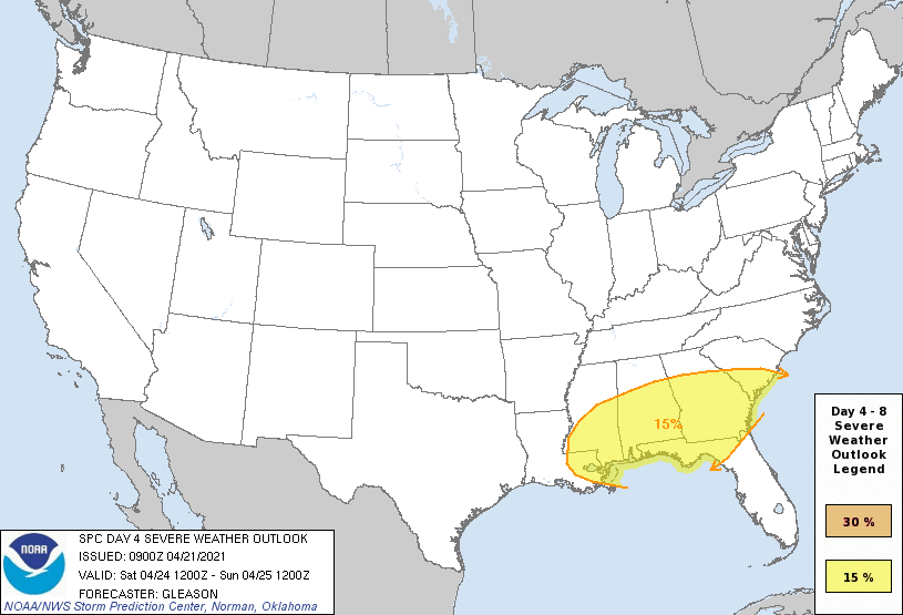
The Storm Prediction Center has expanded the severe weather risk Saturday to include areas along and south of I-20 (Tuscaloosa, Birmingham, Anniston and points south).
There are still some uncertainties on how the day plays out, but there is evidence we could have two rounds of rain and storms: one during the early morning, which would feature some risk of a tornado or two, followed by more storms in the afternoon with the main threat coming from hail and strong winds. Once we get within 60 hours of the event (that will be tonight), we get within range of the convection-allowing models and will have a much better idea of the timing and magnitude of the threat.
Dry air returns Saturday night, and Sunday will be mostly sunny with a high in the mid 70s.
NEXT WEEK: Our weather will be warm and dry Monday and Tuesday; the high will be close to 80 Monday and in the low to mid 80s Tuesday. A rather dynamic weather system will bring showers and storms in here Wednesday and Wednesday night; there could be some risk of severe thunderstorms involved, but it’s too early to know for sure.
RACE WEEKEND: At Talladega, occasional rain and a few strong thunderstorms are likely Saturday, making it a challenge to get the races in. But Sunday will be a beautiful day for the Geico 500, with a sunny sky and a high in the mid 70s.
ON THIS DATE IN 1967: Severe thunderstorms spawned 48 tornadoes in the Upper Midwest. Hardest hit was northern Illinois, where 16 tornadoes touched down during the afternoon and evening, causing $50 million damage. On that Friday afternoon, tornadoes struck Belvidere, Illinois, and the Chicago suburb of Oak Lawn, killing 58 people.
BEACH FORECAST: Click here to see the AlabamaWx Beach Forecast Center page.
WEATHER BRAINS: You can listen to our weekly 90-minute show any time on your favorite podcast app. This is the show all about weather featuring many familiar voices, including the meteorologists at ABC 33/40.
CONNECT: You can find me on the major social networks:
For more weather news and information from James Spann and his team, visit AlabamaWx.


