James Spann: Alabama stays dry through Friday; rain, storms return Saturday
James Spann forecasts dry weather for Alabama ahead of Saturday storms from Alabama NewsCenter on Vimeo.
FROSTY START: Here are some temperatures across Alabama just before sunrise:
- Black Creek — 28
- Fort Payne — 28
- Gadsden — 29
- Haleyville — 29
- Heflin — 29
- Weaver — 31
- Millport — 31
- Meridianville — 31
- Hueytown — 32
- Albertville — 32
- Scottsboro — 32
- Talladega — 32
- Pell City — 32
- Anniston — 33
- Decatur — 33
- Huntsville — 34
- Bessemer — 34
- Prattville — 35
- Demopolis — 36
- Birmingham — 37
- Tuscaloosa — 38
- Montgomery — 42
- Mobile — 44
Look for a sunny sky today with a high in the mid 60s. We stay dry Friday; the sky will be partly sunny with a high in the upper 60s. Clouds increase Friday night.
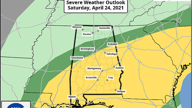
SEVERE STORMS POSSIBLE SATURDAY: A dynamic weather system will bring occasional rain and thunderstorms to Alabama as the weekend begins. The Storm Prediction Center has defined a slight risk (level 2 of 5) for areas along and south of a line from Tuscaloosa to Birmingham to Jacksonville, with a marginal risk (level 1 of 5) as far north as Cullman.
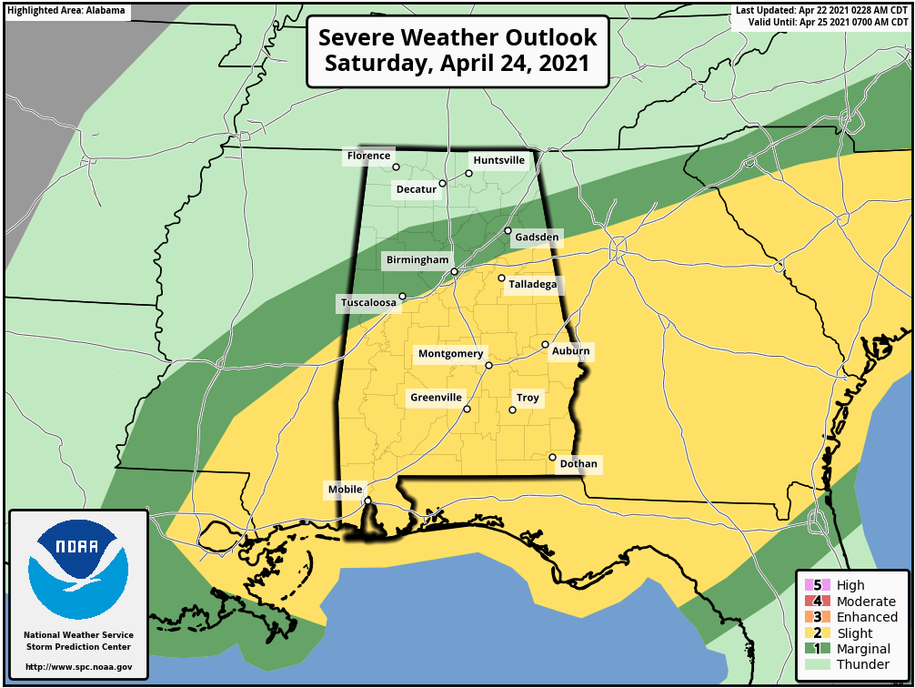
It looks like we will have two rounds of rain and storms. The first will come through during the early morning Saturday, in the general time frame from 1 a.m. until 11 a.m. These storms could produce strong winds and hail, and there is some risk of an isolated tornado or two. The main limiting factor is the lack of surface-based instability; hopefully, this will mitigate the threat to some degree.
After a midday lull, the air becomes unstable by afternoon, and additional showers and storms will likely form ahead of a cold front. These storms could produce large hail and strong straight-line winds. The wind profiles become somewhat unidirectional by afternoon, so for now the tornado threat looks low with this round of storms.
Rain amounts of 1-2 inches are likely Saturday, and a few isolated flooding issues are possible. Most of the rain will be out of the state by 7 p.m. Saturday, and the sky clears Saturday night as dry air returns.
Sunday will be dry with ample sunshine and a high in the mid 70s.
NEXT WEEK: The first half of the week will be warm and dry with mostly sunny days and fair nights. The high will be around 80 degrees Monday, followed by low to mid 80s Tuesday and Wednesday. The next weather system brings thunderstorms into the state Thursday; it’s still too early to know whether severe storms will be an issue, but it certainly is possible.
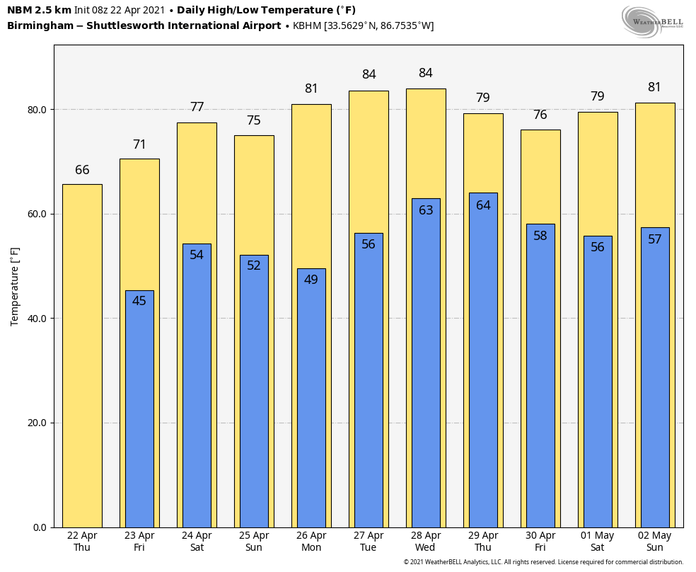
RACE WEEKEND: Saturday will feature occasional rain and a few strong thunderstorms at Talladega; the high will be in the low to mid 70s. But Sunday will be a picture-perfect day for the running of the Geico 500, with lots of sun and a high in the mid 70s.
ON THIS DATE IN 2003: Tropical Storm Ana became the first Atlantic tropical storm since records began in 1871 to form during April. Maximum sustained winds reached 55 mph. Starting as a nontropical area of low pressure on April 18 about 210 miles south-southwest of Bermuda, it was classified as a subtropical storm early on April 20. It gained full tropical characteristics near 0000 UTC on April 21, developing an “eye” feature.
BEACH FORECAST: Click here to see the AlabamaWx Beach Forecast Center page.
WEATHER BRAINS: You can listen to our weekly 90-minute show any time on your favorite podcast app. This is the show all about weather featuring many familiar voices, including the meteorologists at ABC 33/40.
CONNECT: You can find me on the major social networks:
For more weather news and information from James Spann and his team, visit AlabamaWx.


