James Spann: Rain, storms return to Alabama Saturday, some strong to severe
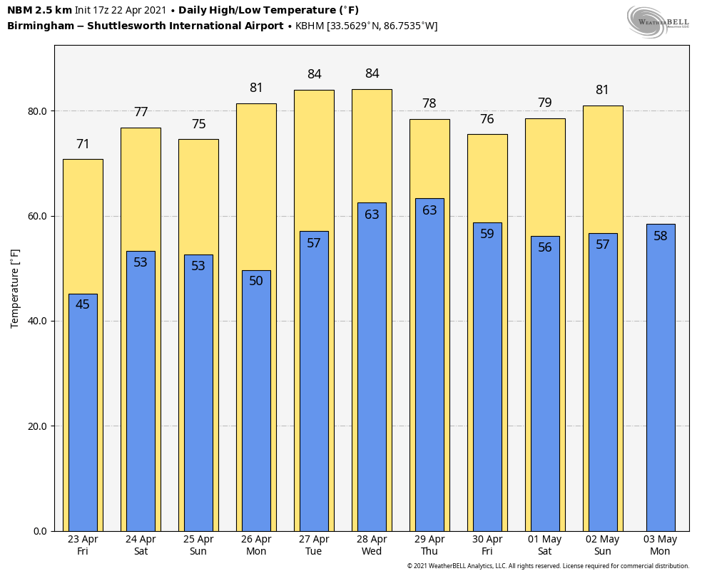
SUNNY BUT COOL: With a sunny sky, temperatures are in the low to mid-60s across most of Alabama this afternoon. The average high for Birmingham on April 22 is 76. Tonight will be clear and not as cold as last night. Lows early Friday morning will be generally between 40 and 48 degrees.
The weather stays dry Friday; with a partly sunny sky the high will be close to 70 degrees. Clouds will increase Friday night.
STORMY SATURDAY: A batch of rain and thunderstorms will move into Alabama after midnight Friday night, and some of those storms could be strong to severe. The Storm Prediction Center has defined a slight risk (level 2 out of 5) of severe thunderstorms for areas south of a line from Tuscaloosa to Birmingham to Jacksonville, with a marginal risk (level 1 of 5) as far north as Cullman.
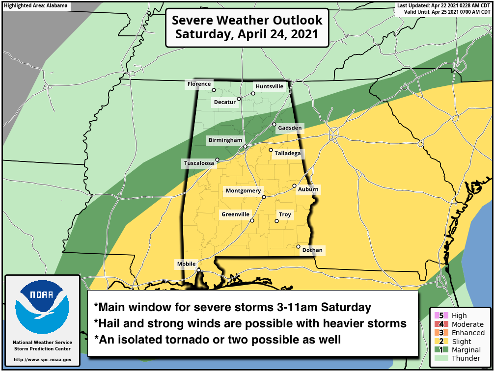
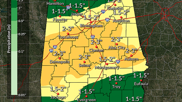
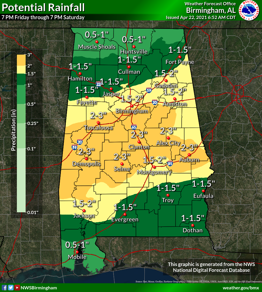
The main window for stronger storms with this round will come from about 3 until 11 a.m. Saturday. Heavier storms will be capable of producing strong winds and hail, and an isolated tornado or two can’t be ruled out. High-resolution model guidance continues to show very little surface-based instability, which should help to mitigate the threat to some degree. The rain will be heavy at times; amounts of 1-2 inches are likely.
After a midday lull, another round of thunderstorms is likely Saturday afternoon ahead of a cold front. These storms could produce small hail and strong, gusty winds. Tornadoes are not expected, as the winds will be unidirectional in the atmosphere by then. Rain amounts of 1-2 inches are likely across most of Alabama Saturday, with isolated totals to 3 inches.
The rain should be over by 5-6 p.m. over the northern half of the state, and by midnight Saturday night over south Alabama. The sky will clear Saturday night, and Sunday will be dry with a good supply of sunshine. Highs over the weekend will be in the low to mid-70s.
NEXT WEEK: Look for warm, dry weather Monday through Wednesday with mostly sunny days and fair nights. The high will be around 80 Monday, followed by mid-80s Tuesday and Wednesday. Another round of showers and storms is likely by Thursday; it’s too early to know whether severe thunderstorms will be an issue.
 RACE WEEKEND: Saturday will feature occasional rain and a few strong thunderstorms at Talladega; the high will be in the low to mid 70s. But Sunday will be a picture-perfect day for the running of the Geico 500, with lots of sun and a high in the mid 70s.
ON THIS DATE IN 2003: Tropical Storm Ana became the first Atlantic tropical storm since records began in 1871 to form during April. Maximum sustained winds reached 55 mph. Starting as a nontropical area of low pressure on April 18 about 210 miles south-southwest of Bermuda, it was classified as a subtropical storm early on April 20. It gained full tropical characteristics near 0000 UTC on April 21, developing an “eye” feature.
BEACH FORECAST: Click here to see the AlabamaWx Beach Forecast Center page.
WEATHER BRAINS: You can listen to our weekly 90-minute show any time on your favorite podcast app. This is the show all about weather featuring many familiar voices, including the meteorologists at ABC 33/40.
CONNECT: You can find me on the major social networks:
For more weather news and information from James Spann and his team, visit AlabamaWx.


