James Spann: Warm, humid day for Alabama, with more showers, storms ahead
James Spann has the forecast for a new Alabama work week from Alabama NewsCenter on Vimeo.
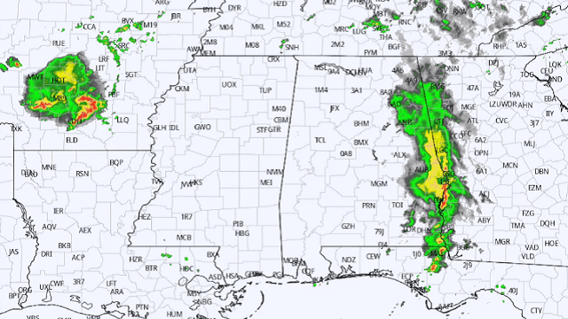
RADAR CHECK: Most of the rain in Alabama was near the Georgia state line at sunrise; the rest of the state is mostly cloudy with temperatures around 70 degrees. While the rain across the state today won’t be as widespread as on Sunday, more showers and thunderstorms will form later this morning and into the afternoon as an upper trough persists just west of the state. Odds of any one spot seeing rain later today are 55-65%, and the high will be in the low to mid 80s with more clouds than sun.
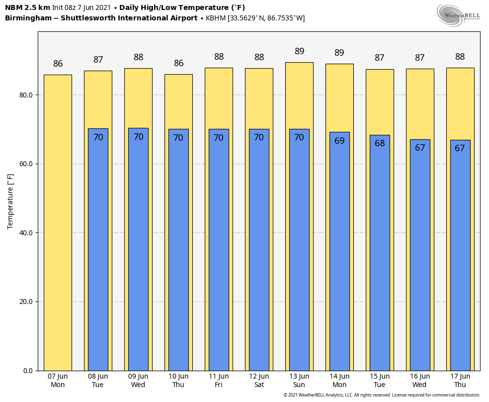
REST OF THE WEEK: The overall pattern won’t change much. Moist, unstable air will stay in place and we will have some risk of showers and thunderstorms daily. The best chance of rain each day will come during the afternoon and evening, but we can’t rule out a few late-night or morning showers along the way. The sun will be out at times, but the sky will be generally cloudy with highs in the mid 80s on most days. The highest coverage of showers will be generally over the northern half of the state, with the activity a bit more widely scattered near the coast.
THE ALABAMA WEEKEND: You should see some sun Saturday and Sunday. We expect a mix of sun and clouds both days, but again we will deal with scattered showers and thunderstorms. Highs over the weekend will be in the mid to upper 80s, right at seasonal averages for mid-June in Alabama.
NEXT WEEK: There is some evidence the air could be a little drier across the Deep South early next week with fewer showers, but we will believe that when we see it. For now we will stick with a persistence forecast with partly sunny days and the daily round of scattered, mostly afternoon and evening showers and thunderstorms. Highs will hold in the 80s.
SUNDAY’S RAIN: Here are some rain totals from the ABC 33/40 Skywatchers:
- Coker — 2.55 inches
- Alabaster — 2.33
- Cottondale — 2.24
- Fayette — 2.18
- Carbon Hill — 2.16
- Eutaw — 1.99
- Demopolis — 1.78
- Vance — 1.69
- Westover — 1.68
- Lay Lake — 1.37
- Bessemer — 1.33
- Gardendale — 1.32
- Leeds — 1.17
- Jacksonville — 1.17
- Hueytown — 1.08
- Weaver — 0.93
- Good Hope — 0.8
- Oneonta — 0.47
- Rainbow City — 0.45
TROPICS: The Atlantic basin is quiet now, but an area of low pressure is expected to develop over the southwestern Caribbean Sea by Thursday or Friday. Some gradual development will be possible thereafter as the system moves slowly northwestward toward Central America this weekend.
ON THIS DATE IN 1980: Thunderstorms caused downed trees and power lines as well as street flooding all across western New York. A wind gust of 79 mph was observed at greater Buffalo International Airport. Golf-ball-sized hail was reported north and east of the city.
BEACH FORECAST: Click here to see the AlabamaWx Beach Forecast Center page.
WEATHER BRAINS: You can listen to our weekly 90-minute show any time on your favorite podcast app. This is the show all about weather featuring many familiar voices, including the meteorologists at ABC 33/40.
CONNECT: You can find me on the major social networks:
For more weather news and information from James Spann and his team, visit AlabamaWx.


