Scott Martin: Tropical Storm Claudette brings rain to Alabama today, early Sunday
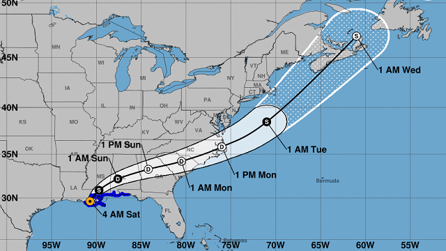
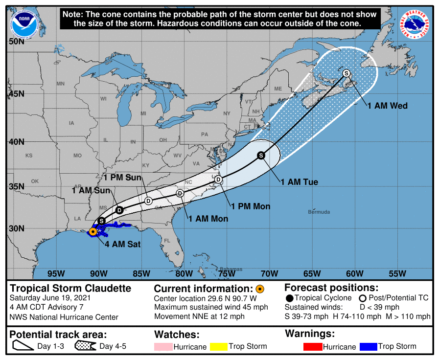
CLAUDETTE: At 4 a.m., an hour or so after Potential Tropical Cyclone 3 made landfall just south-southwest of Houma, Louisiana, the National Hurricane Center upgraded it to Tropical Storm Claudette.
Claudette will turn more to the east-northeast later today and move across southern central Alabama starting late tonight and on Sunday before accelerating and moving offshore of North Carolina on Monday. Forecasts now have Claudette reforming into a tropical storm by early Tuesday morning.
We’ll continue to have the threat of heavy rainfall throughout the day today, some of which may cause some flooding, especially south of the I-20 corridor. The latest projected rainfall totals show anywhere from 2 to 4 inches of rain through Sunday evening for much of Alabama with some localized amounts of 4 to 6 inches, especially south of the I-20 corridor. North of that, rainfall amounts really taper off to one-quarter inch to 2 inches for northern Alabama. A Flash Flood Watch went into effect at 7 a.m. for a good portion of Alabama and is set to expire at 7 p.m. Sunday.
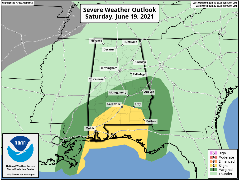
Along with the heavy rain threat, a few brief spin-up tornadoes will be possible over southern Alabama, and the Storm Prediction Center has a marginal risk up from just south of Demopolis to just north of Clanton to Roanoke throughout Saturday.
As Claudette moves through, rain will be widespread and likely for nearly the entire state later this morning before we start to see a little dryness start to work into southwestern Alabama this afternoon. The activity looks to be more abundant over the northern half of the system tonight, with some heavier banding set up over the southeastern parts. Once we reach the overnight hours, much of the activity will have moved over into Georgia, leaving us with scattered showers on the western side of the center. By daybreak Sunday, only the eastern half of the state looks to be dealing with any shower activity from Claudette. By midday, we can officially say goodbye to her. A few scattered showers will remain possible for the rest of the day, but much of the state will be dry.
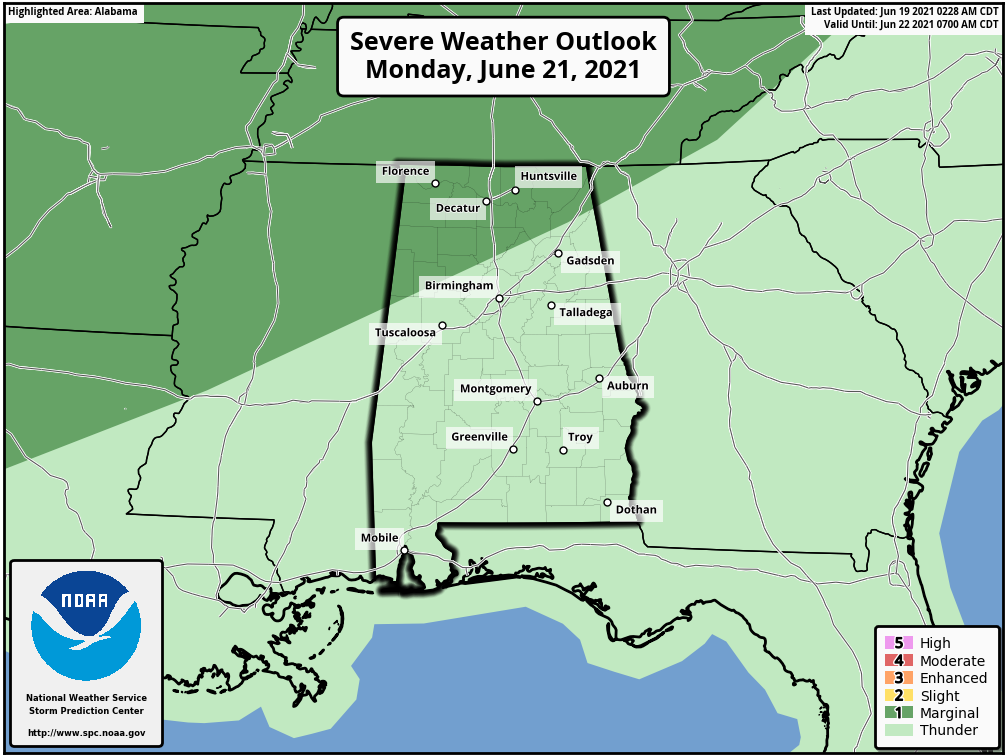
THE WORK WEEK: Our focus will shift to a cold front that will be moving in our direction from the northwest on Monday. Out ahead of the front, we could have scattered shower and thunderstorm development across much of Alabama, some of which may become briefly strong to severe over the northern parts of the state. A marginal risk is defined for locations along and north of a line from Ethelsville (Pickens County) to Black Bottom (Cullman County) to Fort Payne (DeKalb County). Damaging winds up to 60 mph will be the main threat, but we’ll get a better look at that after Claudette moves out. Highs will be in the mid to upper 80s.
The front will finally push through on Tuesday and the shower and storm threat will end for much of the state by late afternoon to early evening. After that, the front appears to wash out over the extreme southern parts of the state. Highs will be in the mid-70s to the lower 80s.
Wednesday will feature a few scattered showers and storms over the southern half of the state, while the northern half looks to stay rain-free. Highs will be in the lower to mid-80s.
Thursday will be mainly dry with plenty of sunshine, but there will be enough moisture that a few isolated to scattered afternoon showers and storms will be possible. Highs will be in the mid to upper 80s.
Another impulse will be moving in our direction from the north-northwest on Friday that may bring a decent chance of showers and storms to the extreme northern parts of the state late in the day, but much of the rest will stay dry with only a small chance of an afternoon shower or storm. Highs will be in the mid to upper 80s.
For more weather news and information from James Spann, Scott Martin and other members of the James Spann team, visit AlabamaWx.


