James Spann: Scattered showers Thursday, more widespread rain for Alabama Friday
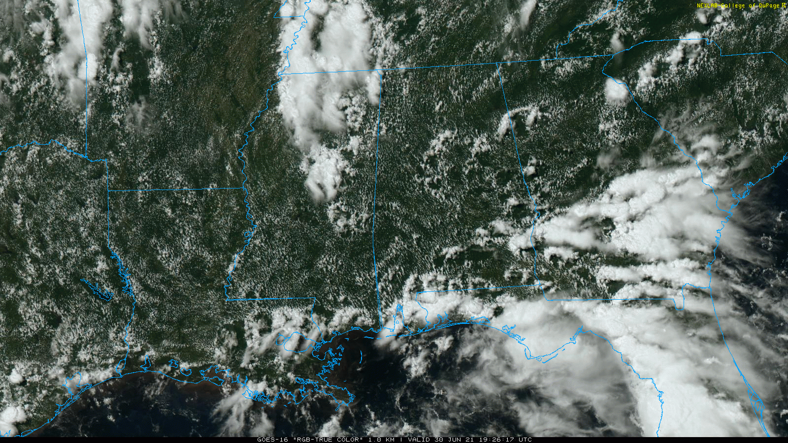
RADAR CHECK: We have the classic case of random, scattered showers and thunderstorms across Alabama this afternoon. Showers are moving northwest and are a little more numerous over the southern quarter of the state, thanks to the daily sea-breeze front. Away from the showers, the sky is partly sunny with temperatures mostly in the mid to upper 80s. Showers will fade away after sunset.
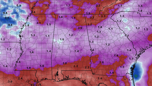
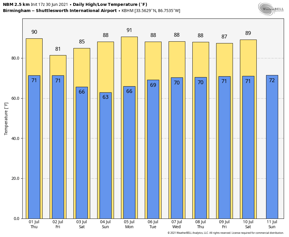
THURSDAY AND FRIDAY: Thursday will be another warm, humid day for Alabama with a mix of sun and clouds, and again we will see developing showers and thunderstorms in scattered spots. The chance of any one spot getting wet is 40-50% and the high will be in the 84- to 88-degree range for most communities. Rain and thunderstorms will be more widespread Friday as a rare July cold front approaches from the north. It won’t rain all day, but periods of rain and a few storms are likely through the day. Temperatures will hold in the 70s in many areas because of clouds and rain; amounts of around 1 inch are likely.
THE HOLIDAY WEEKEND: The front is expected to push into south Alabama Friday night and dry air moves into the northern two-thirds of the state, setting the stage for a very nice holiday weekend. We expect partly to mostly sunny days, cooler nights and lower humidity. Highs will be in the 80s, and many north Alabama cities will dip into the 50s early Sunday morning — pretty unusual for the Fourth of July around here.
Scattered showers and storms will remain possible over the weekend over the southern quarter of the state, mainly south of U.S. 84, but even there it won’t be a washout.
NEXT WEEK: The northern half of the state will remain dry Monday; then, as moisture levels rise, we will bring back the chance of scattered showers and storms Tuesday through Friday. There is a good bit of uncertainty in the forecast as we will have a tropical system nearby; for now it looks like it will remain east of our state, but that could change. Highs will be in the 80s.
TROPICS: Showers and thunderstorms continue in association with a tropical wave over the Lesser Antilles. This system has become less organized since Tuesday, and significant development is no longer expected while it moves quickly westward across the Caribbean Sea.
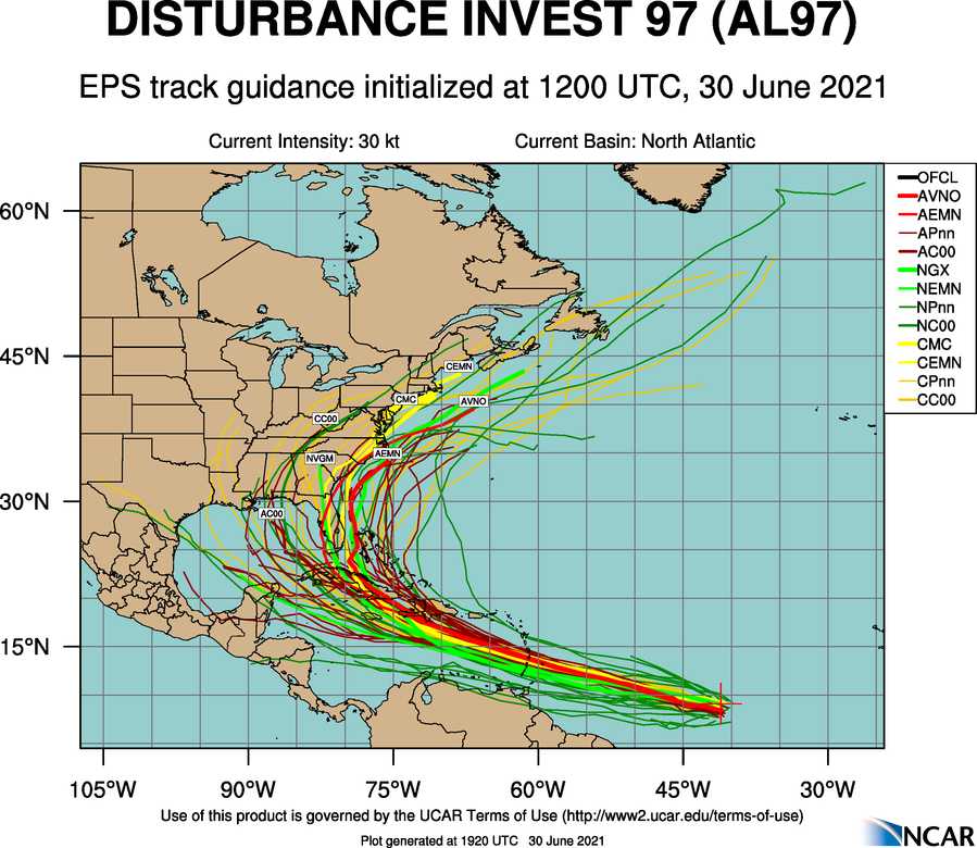
To the east, showers and thunderstorms associated with a broad low-pressure area and tropical wave about 1,300 miles east-southeast of the Windward Islands have become better organized since Tuesday. However, recent satellite wind data indicates that the disturbance does not have a well-defined circulation. Environmental conditions appear generally favorable for continued development, and a tropical depression or storm is likely to form during the next day or two while the system moves west-northwestward at 20 to 25 mph. Interests in the Lesser Antilles should closely monitor the progress of this system, as advisories on a potential tropical cyclone, accompanied by tropical storm watches for portions of this area, are likely to be issued later today.
It is still too early to know whether this system will reach the Gulf of Mexico or Florida, or recurve east of the U.S. Once it gets better organized and we get good upper-air dropsonde data from hurricane hunters, confidence will increase. The name will be Elsa.
ON THIS DATE IN 1912: An estimated F4 tornado ripped through Regina, Saskatchewan, Canada. The storm became the deadliest tornado in Canada’s history as it killed 28 people along a rare, 18.5-mile track from south to north.
BEACH FORECAST: Click here to see the AlabamaWx Beach Forecast Center page.
WEATHER BRAINS: You can listen to our weekly 90-minute show any time on your favorite podcast app. This is the show all about weather featuring many familiar voices, including the meteorologists at ABC 33/40.
CONNECT: You can find me on the major social networks:
For more weather news and information from James Spann and his team, visit AlabamaWx.


