James Spann: August front creeping southward across Alabama today
James Spann forecasts a break in the heat to start the Alabama work week from Alabama NewsCenter on Vimeo.
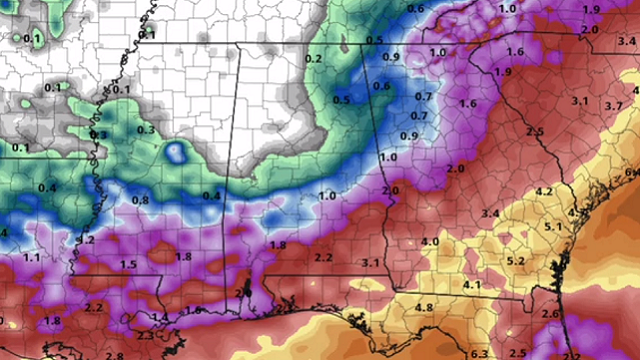
RARE AUGUST FRONT: A “cold front” is north of I-20 this morning; you don’t see those around here that often in early August. North of the front, the air is drier and temperatures are in the mid 60s in many places. But to the south, humid air lingers with temperatures in the 70s. We had a cluster of showers and storms riding along the front over west Alabama just before daybreak.
Look for more clouds than sun today, and a few passing showers and storms are likely over the southern two-thirds of the state, south of the surface boundary. On the positive side, heat levels will be way down today. Most places will see a high only in the low to mid 80s across north and central Alabama, almost 10 degrees below average for early August.
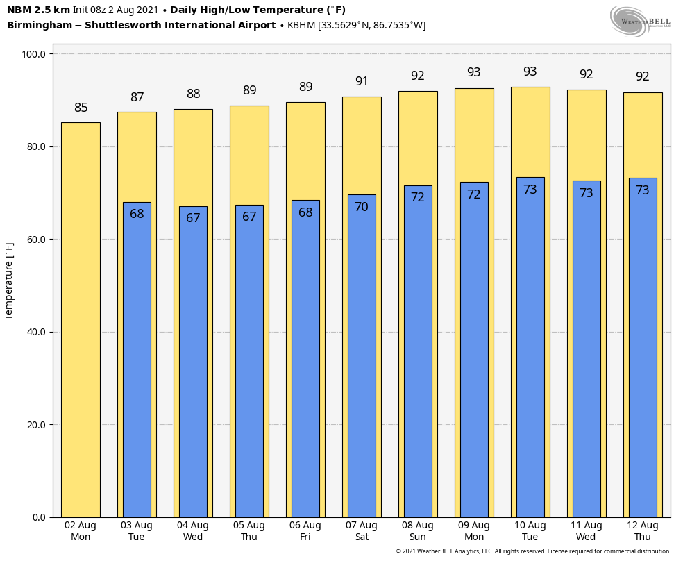
REST OF THE WEEK: Showers and storms Tuesday will be mainly confined to the southern third of Alabama as the front creeps southward. For north and central Alabama, the sky will be partly to mostly sunny with a high between 85 and 88 degrees. Showers will be hard to find over the northern half of the state.
Wednesday through Friday, we expect partly sunny days with just a few widely scattered showers and storms as the front washes out over south Alabama. Highs will be generally in the upper 80s.
THE ALABAMA WEEKEND: Partly sunny weather is forecast Saturday and Sunday, and a few pop-up afternoon showers or storms could form in scattered spots. The high Saturday and Sunday will be close to 90 degrees.
NEXT WEEK: The quiet pattern continues — partly sunny days with a few scattered, mostly afternoon and evening showers and thunderstorms possible. Highs will be in the low 90s.
TROPICS: All remains very quiet across the Atlantic basin this morning thanks to dry air and subsidence; tropical storm formation is not expected this week.
LOOKING BACK AT JULY: Birmingham’s average temperature for July was 89.1 degrees, below the average of 91. The rain total was 8.66 inches, well above the average of 5.42 inches but not close to the record of 20.12 inches, set in 1916. In fact, July 2021 didn’t even make the top 15 in terms of rain amounts.
ON THIS DATE IN 1985: Delta flight 191 crashed at Dallas-Fort Worth airport at 6:05 p.m., killing 137 people. The National Transportation Safety Board’s Accident Board determined that the cause of the incident was wind shear associated with an intense thunderstorm downdraft that occurred at the north end of the airport along runway 17 Left. Today we know this intense, localized downburst as a microburst, a weather phenomenon that was not well understood at the time of the accident. Delta 191’s aftermath changed how regulators approached weather threats, how pilots talked to each other in the cockpit and even how fire rescue crews at airports save lives at crashes.
BEACH FORECAST: Click here to see the AlabamaWx Beach Forecast Center page.
WEATHER BRAINS: You can listen to our weekly 90-minute show any time on your favorite podcast app. This is the show all about weather featuring many familiar voices, including the meteorologists at ABC 33/40.
CONNECT: You can find me on the major social networks:
For more weather news and information from James Spann and his team, visit AlabamaWx.


