James Spann: Fred heads for Florida Panhandle, then southeast Alabama
James Spann forecasts Tropical Storm Fred’s potential impacts for Alabama from Alabama NewsCenter on Vimeo.
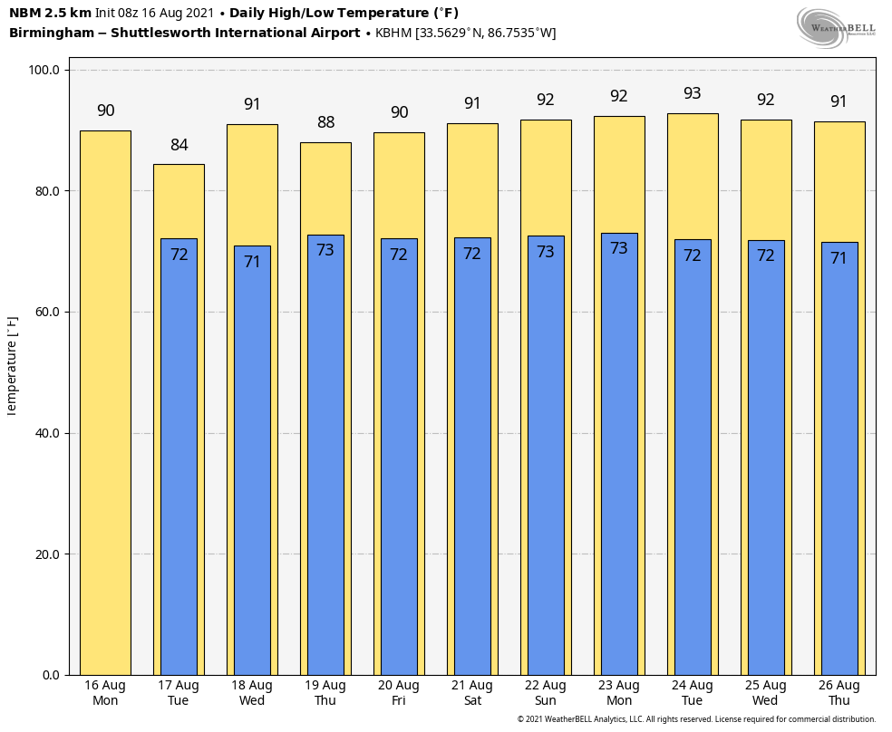
RADAR CHECK: We have rain falling early this morning across northeast Alabama and a few isolated showers over the western counties. The rest of the state is dry with temperatures mostly in the low 70s. Clouds will increase today statewide, and scattered showers and storms will develop during the day. Today’s high will be between 85 and 89 degrees for most places; the average high for Aug. 16 at Birmingham is 91.
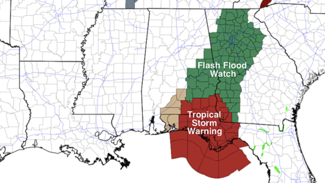
FRED: Tropical Storm Fred, now with winds of 50 mph, will move into the Florida Panhandle this evening. A Tropical Storm Warning remains in effect for the coast of the Panhandle from Navarre to the Wakulla/Jefferson county line. As you look at the forecast maps, remember the main wind and rain impact will be along and east of the circulation center.
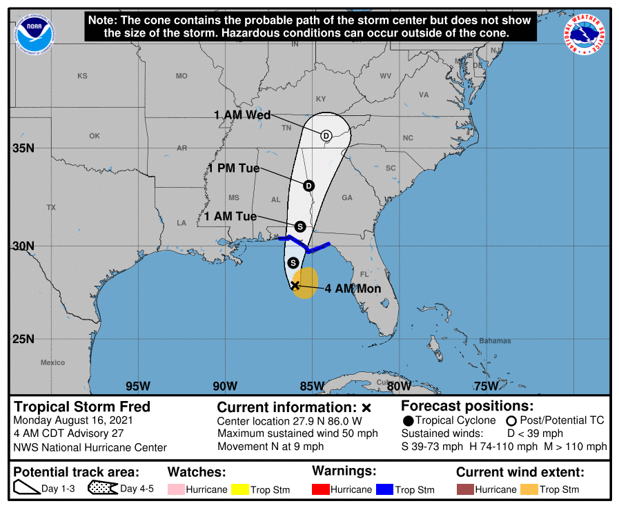
Here is a look at the expected impact.
COASTAL: Winds could gust to 60 mph in the tropical storm warning area later today and tonight, and a 3- to 5-foot storm surge is forecast from Indian Pass to Steinhatchee River. A 1- to 3-foot storm surge is forecast from Perdido Key (the Alabama/Florida border) to Indian Pass, including Pensacola Bay, Choctawhatchee Bay and Saint Andrew Bay.
A few isolated waterspouts and tornadoes are possible this afternoon and tonight on the coast from Navarre all the way over to Tampa Bay. Rain amounts of 3-6 inches are likely on the Florida coast over the next 24 hours along and east of the circulation center, in the general area from Destin to Saint Marks.
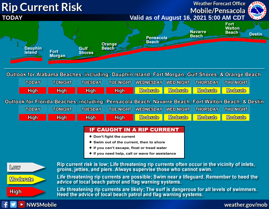
The Alabama Gulf Coast is on the dry, west side of the system and there will be minimal impact other than rip currents. The rip current danger is high through the central Gulf Coast through Tuesday night.
Weather conditions improve along the Gulf Coast Tuesday, and routine weather is expected Tuesday through the rest of the week with the usual mix of sun and scattered storms.
INLAND ALABAMA: A Flash Flood Watch is in effect through Tuesday for east and southeast Alabama, in the general area from Wedowee and Roanoke south to Andalusia, Geneva and Dothan. Rain amounts of 2-4 inches are possible there over the next 48 hours; amounts will be much lower on the western side of the state.
A few brief, isolated tornadoes are also possible in the same general area as the Flash Flood Watch (east and southeast Alabama) later today and tonight; there is a slight risk of severe weather (level 2 of 5) around Dothan and Ozark, with a marginal risk (level 1 of 5) as far north as Clay, Cleburne and Randolph counties.
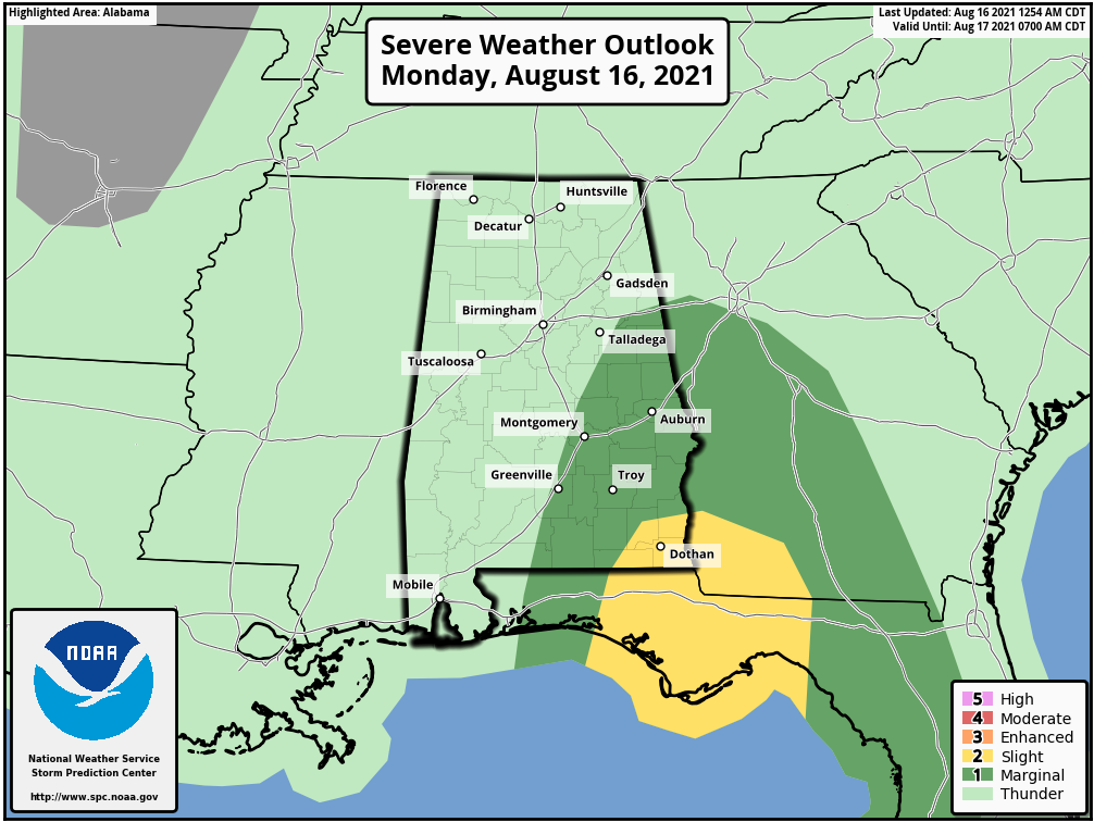
Winds from Fred could gust to 45 mph around Dothan tonight; gusts farther inland across east and southeast Alabama will be in the 25-35 mph range.
REST OF THE WEEK AND THE WEEKEND: We expect fairly routine weather across Alabama Wednesday through Sunday, with a mix of sun and clouds each day along with scattered showers and thunderstorms, most active during the afternoon and evening hours. Highs will be between 88 and 91 degrees. The chance of any one spot getting wet each day is 50-70%, and most of the showers and storms will come from noon to midnight.
The same pattern will continue next week, although showers and storms should be a little fewer in number as an upper ridge builds into the region. Highs next week will be mostly in the low 90s.
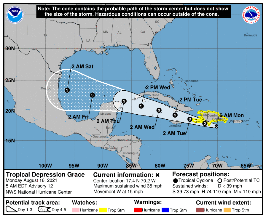
REST OF THE TROPICS: Tropical Depression Grace is near the southern coast of the Dominican Republic with winds of 35 mph; the latest forecast track from the National Hurricane Center keeps it south of Cuba, with a position nearing the coast of Mexico (south of Brownsville, Texas) Saturday as a tropical storm. Grace is not a threat to the central Gulf Coast.
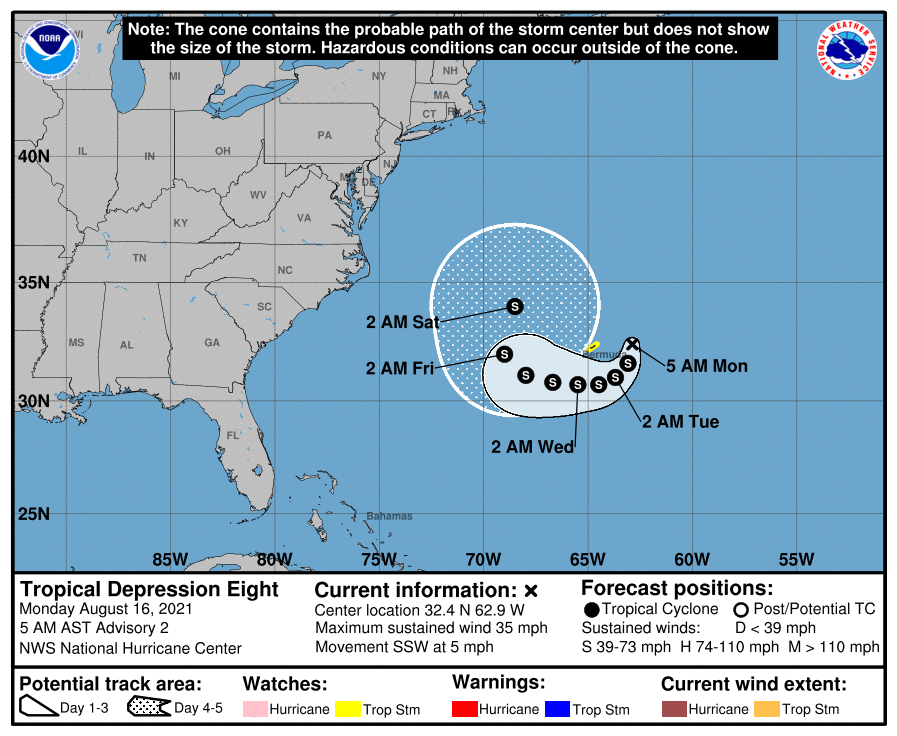
Tropical Depression Eight will loop around Bermuda over the next 48 hours before moving out into the open North Atlantic. It is no threat to the U.S.
ON THIS DATE IN 1992: One of the most destructive United States hurricanes of record started modestly as a tropical wave that emerged from the west coast of Africa on Aug. 14. The wave spawned a tropical depression on Aug. 16, which became Tropical Storm Andrew the next day.
BEACH FORECAST: Click here to see the AlabamaWx Beach Forecast Center page.
WEATHER BRAINS: You can listen to our weekly 90-minute show any time on your favorite podcast app. This is the show all about weather featuring many familiar voices, including the meteorologists at ABC 33/40.
CONNECT: You can find me on the major social networks:
For more weather news and information from James Spann and his team, visit AlabamaWx.


