James Spann: A few strong storms over northwest Alabama today
James Spann has the Alabama forecast for midweek from Alabama NewsCenter on Vimeo.
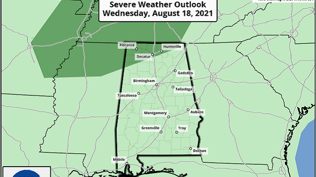
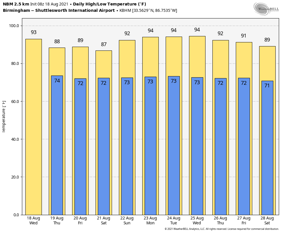
HOT, HUMID DAY AHEAD: We expect a pretty decent amount of sun across Alabama today with a high around 90 degrees this afternoon, but a few pop-up storms are possible during the peak of the heat. The better chance of thunderstorms is across the Tennessee Valley of north Alabama, and the Storm Prediction Center has a low-end marginal risk (level 1 out of 5) of severe storms defined for areas north of a line from Hamilton to Decatur to Huntsville. A disturbance could bring a few thunderstorms there with strong, gusty winds.
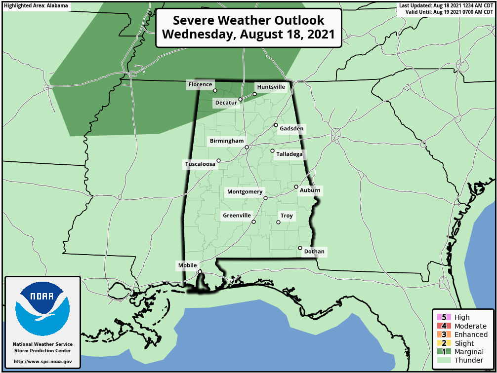
South of the marginal risk, storms will be isolated; odds of any one spot getting wet are only about 15-25%.
THURSDAY THROUGH SATURDAY: The air aloft will be a bit colder and the air overall more unstable. We expect scattered to numerous showers and thunderstorms Thursday through Saturday, mostly from noon to midnight. The chance of any one location seeing rain each day is 55-65%, and highs will drop back into the mid to upper 80s with a more limited amount of sun.
SUNDAY AND NEXT WEEK: An upper ridge begins to build across the Deep South, meaning increasing amounts of sun and higher heat levels, and fewer showers Sunday and through the first half of next week. Highs will be mostly in the low 90s, although a few places could reach the mid 90s. Afternoon showers and storms will likely be pretty scarce Sunday through Tuesday. Then the ridge weakens a bit and scattered afternoon thunderstorms will increase Wednesday through Friday.
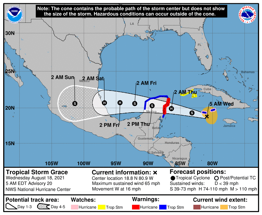
TROPICS: Tropical Storm Grace, with winds of 65 mph, is very close to Grand Cayman this morning. It is moving west and will cross the Yucatan Peninsula Thursday, then move into the coast of Mexico far south of Brownsville, Texas, Friday night. It is expected to be a Category 1 hurricane at both landfall points. While Grace will remain far south of the U.S., it will bring a high danger of rip currents to the central Gulf Coast Friday.
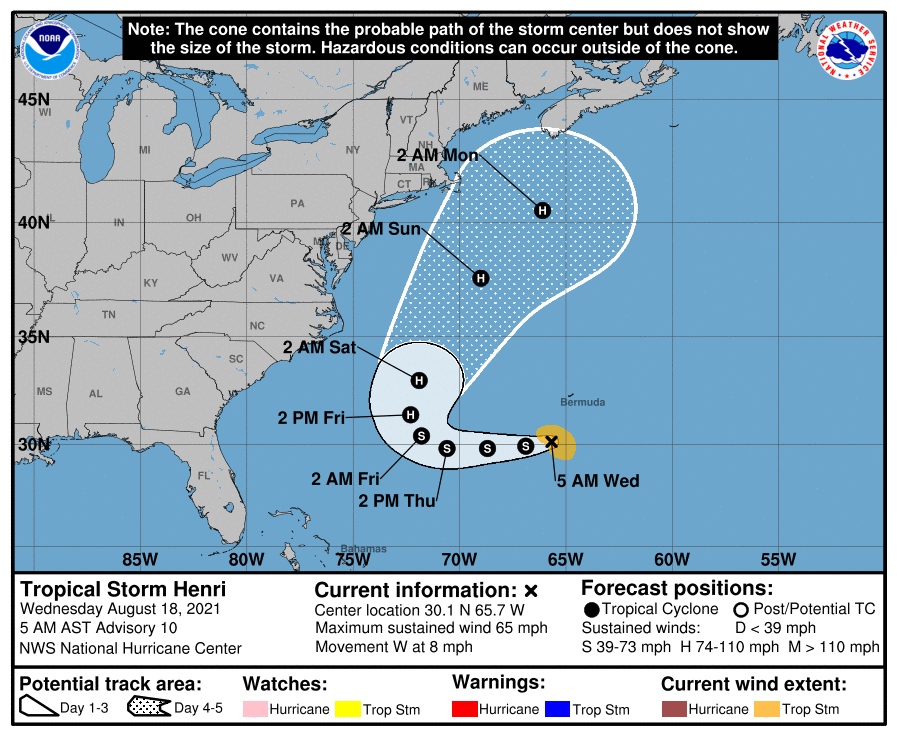
Tropical Storm Henri also has winds of 65 mph in the Atlantic; it is 160 miles south of Bermuda. It will move westward through Friday but will take a sharp turn to the north Friday night, staying east of the U.S. as a Category 1 hurricane.
We see no tropical trouble for the central Gulf Coast through the next seven days, but the peak of the hurricane season runs through September and early October. We still have a long way to go.
ON THIS DATE IN 1983: Hurricane Alicia made landfall at Category 3 strength on the southwestern end of Galveston Island, Texas. Alicia’s eye passed just west of downtown Houston, producing widespread damage. Thousands of homes were destroyed. In downtown Houston, nearly all skyscrapers lost approximately half of lower-level windows, littering the urban streets with debris. Widespread power outages and flooding affected much of southeast Texas, with observed rainfall totals peaking at 9.95 inches. In addition to the strong winds, rough surf and heavy rain, Alicia generated 22 tornadoes around the Houston–Galveston area; most were rated F0, but the strongest, an F2, tore through Corsicana farther north.
BEACH FORECAST: Click here to see the AlabamaWx Beach Forecast Center page.
WEATHER BRAINS: You can listen to our weekly 90-minute show any time on your favorite podcast app. This is the show all about weather featuring many familiar voices, including the meteorologists at ABC 33/40.
CONNECT: You can find me on the major social networks:
For more weather news and information from James Spann and his team, visit AlabamaWx.


