James Spann: Moisture levels rise in Alabama this week; eyes on Nicholas
James Spann has the Alabama forecast to kick off the work week from Alabama NewsCenter on Vimeo.
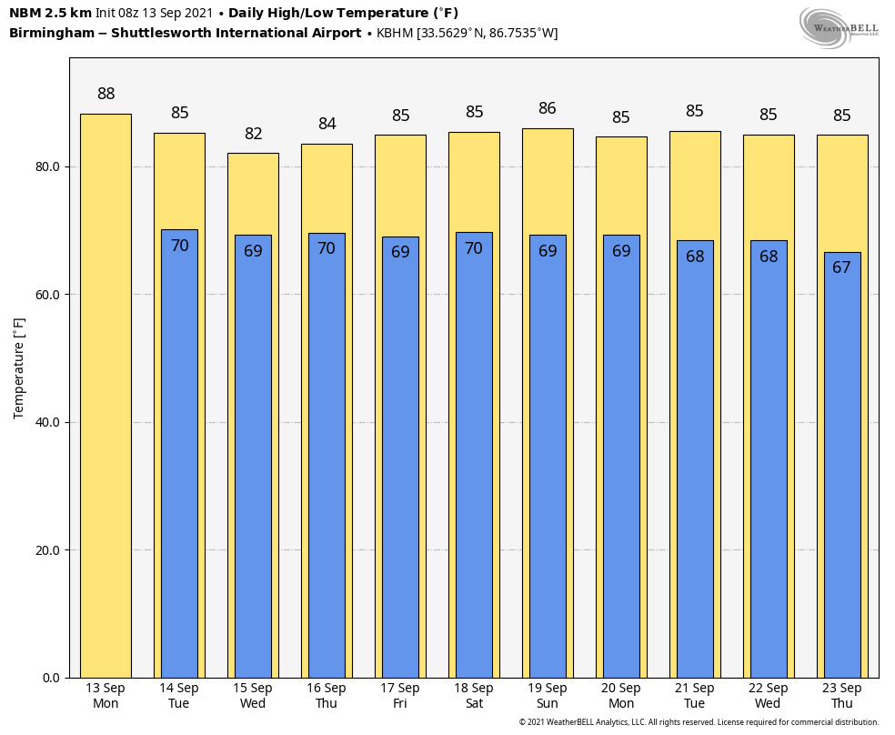
HIGHER RAIN CHANCES AHEAD: We will forecast a partly sunny sky across Alabama today, and a few scattered showers could form this afternoon and tonight as moisture levels begin to rise across the state. The high this afternoon will be in the mid to upper 80s; the average high for Birmingham on Sept. 13 is 87.
Scattered showers will be more numerous Tuesday, and the weather will be pretty wet across the state Wednesday and Thursday with deeper tropical moisture pulled northward from Tropical Storm Nicholas to the west. Look for periods of rain and possibly a few thunderstorms both days with temperatures generally holding in the 70s because of clouds and rain.
FRIDAY AND THE WEEKEND: An upper ridge will hold over the region with a moist air mass in place. We expect a mix of sun and clouds Friday through Sunday with scattered showers and storms daily, most active from noon to midnight. The chance of any one spot getting wet each day is 45-55%, and highs will be in the mid 80s, right at seasonal averages for mid-September. Humidity levels will remain fairly high over the weekend.
NEXT WEEK: The ridge holds through the week, meaning warm, humid weather will continue with the typical mix of sun, scattered showers and thunderstorms daily. Highs will be in the 80s.
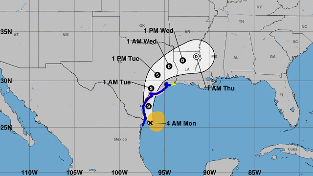
 NICHOLAS: Tropical Storm Nicholas is packing winds of 60 mph this morning in the western Gulf of Mexico; the center is 45 miles southeast of the southern tip of Texas. Nicholas is forecast to approach the middle Texas coast as a strong tropical storm today and could be near hurricane intensity at landfall. Tropical storm conditions are expected along portions of the middle Texas coast beginning this afternoon, with hurricane conditions possible this afternoon and tonight from Port Aransas to Freeport, where a Hurricane Watch is in effect.
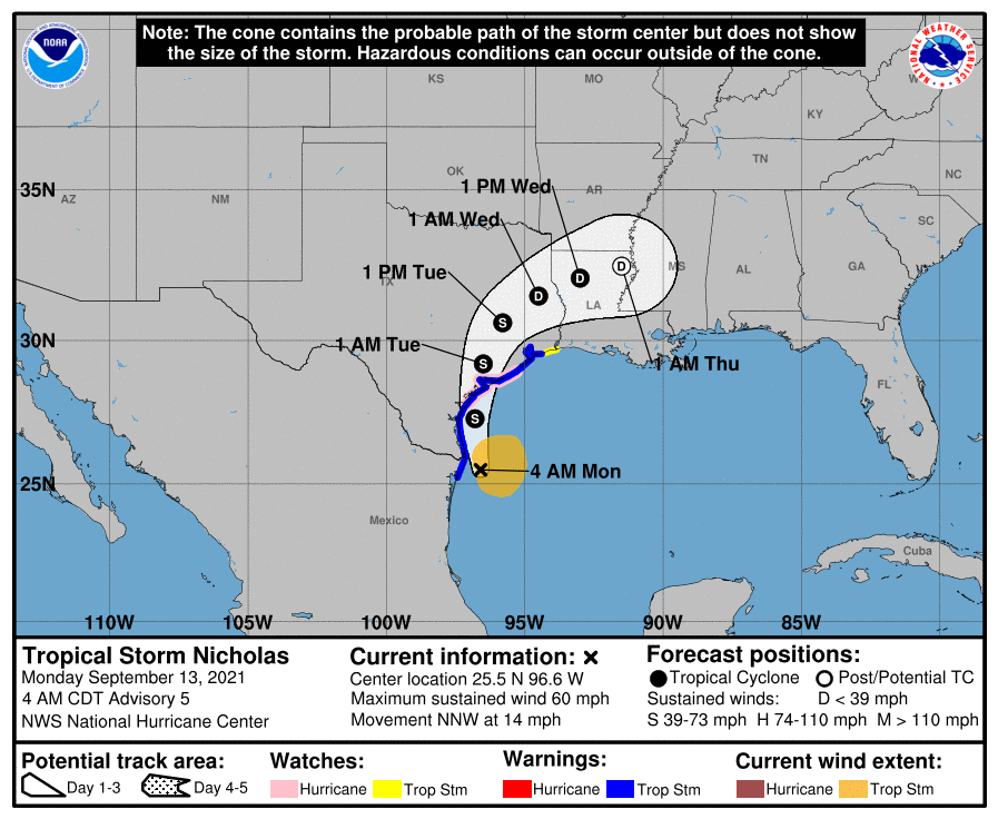 Heavy rainfall will affect portions of the Texas and Louisiana coasts through the middle of the week. Significant rainfall amounts are possible, potentially resulting in areas of considerable flash and urban flooding, especially in highly urbanized metropolitan areas, including Houston. Isolated minor to moderate river flooding is also expected.
There is also the danger of life-threatening storm surge inundation along the coast of Texas from Port Aransas to San Luis Pass.
The direct impact of Nicholas will remain west of Alabama and the central Gulf Coast (Gulf Shores to Panama City Beach), but the circulation around the system will bring in deeper moisture over the next few days, meaning higher rain chances.
REST OF THE TROPICS: A tropical wave is expected to emerge off the west coast of Africa later today. Environmental conditions are forecast to be conducive for gradual development of this system thereafter, and a tropical depression is likely to form by late this week while it moves westward at 10 to 15 mph across the eastern tropical Atlantic Ocean. It’s too early to know whether this will affect the Lesser Antilles or the U.S.
An area of low pressure is forecast to form by midweek a couple of hundred miles north of the southeastern or central Bahamas as a tropical wave interacts with an upper-level trough. Some gradual development of this system is possible thereafter, and a tropical depression could form later this week while the system moves north-northwestward or northward across the western Atlantic, east of the U.S.
ON THIS DATE IN 1979: Hurricane Frederic was moving northward through Mobile Bay before dawn after making landfall on the night of Sept. 12. A wind gust of 145 mph was measured on equipment atop the Dauphin Island Bridge, which was destroyed. A wind gust of 139 mph was measured at the Dauphin Island Sea Lab before the equipment failed. A storm surge of 12 feet was observed in Gulf Shores. Nearly all structures within 200 yards of the Alabama coast were destroyed. There were two fatalities as a direct result of Frederic. Total damages were $2.3 billion, making Frederic the most expensive hurricane ever to strike the United States to that point.
ON THIS DATE IN 1988: Hurricane Gilbert smashed into the Cayman Islands, and as it headed for the Yucatan Peninsula of Mexico it strengthened into a monster hurricane, packing winds of 175 mph. The barometric pressure at the center of Gilbert reached 888 millibars, a record for any hurricane in the Caribbean, Gulf of Mexico or the Atlantic Ocean until Hurricane Wilma in 2005. Gilbert covered much of the Gulf of Mexico, producing rain as far away as the Florida Keys.
BEACH FORECAST: Click here to see the AlabamaWx Beach Forecast Center page.
WEATHER BRAINS: You can listen to our weekly 90-minute show any time on your favorite podcast app. This is the show all about weather featuring many familiar voices, including the meteorologists at ABC 33/40.
CONNECT: You can find me on the major social networks:
For more weather news and information from James Spann and his team, visit AlabamaWx.


