James Spann: Not as cold in Alabama today
James Spann forecasts a modest warm-up for Alabama from Alabama NewsCenter on Vimeo.
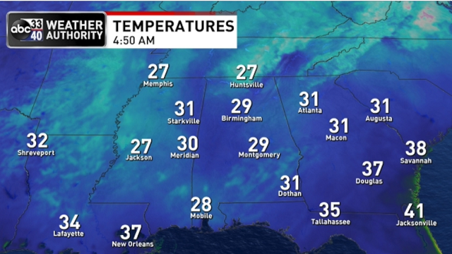
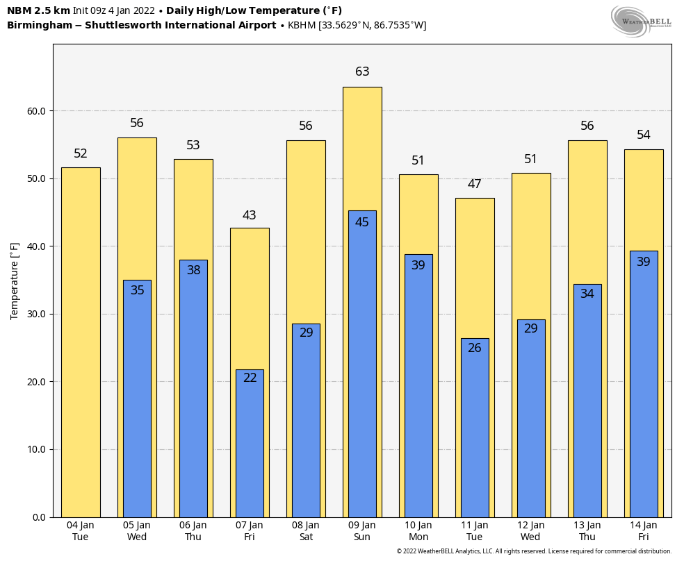
COLD START: Temperatures are mostly in the 20s across Alabama this morning; even Mobile had dropped to 28 degrees just before daybreak. The sky is clear, and we expect a sunny day with a high in the mid 50s, right at seasonal averages for early January in Alabama. Dry weather continues Wednesday, although clouds will increase by afternoon; the high will be back in the mid 50s.
THURSDAY: We expect periods of rain Thursday as a new push of cold air begins to arrive. Temperatures will be in the 30s and 40s through the day for most of the state. There is a chance the precipitation could begin as a wintry mix Thursday morning over far northern Alabama, especially along and north of the Tennessee River. Some sleet and snow is possible early in the day for places like Florence, Athens, Huntsville and Scottsboro, but for now it looks like surface temperatures will be a little above freezing. The best chance of accumulating snow with the system will be in Tennessee.
Rain ends Thursday evening, and the coldest air so far this season will push into the state Friday. We project lows early Friday morning between 18 and 23 degrees, with a wind chill index down to about 10 degrees. Friday will be sunny with a high between 35 and 42 degrees.
THE ALABAMA WEEKEND: Dry weather continues Saturday; after a low in the 20s we project a high in the low to mid 50s. Clouds increase Saturday night, and rain returns Sunday ahead of another cold front. Some thunder is possible, but severe storms are not expected.
NEXT WEEK: Rain ends early in the day Monday; clouds will linger much of the day with temperatures holding in the 40s. The rest of the week looks mostly dry with seasonal temperatures (highs in the 50s, lows in the 30s). Some rain could return on Friday, Jan. 14.
 BAMA SNOW: The heaviest snow total Sunday night was at Moores Mill, in Madison County (near Huntsville), where the total was 7 inches. Other totals across the Tennessee Valley included:
- Harvest — 6.3 inches
- Meridianville — 6
- Mentone — 6
- Owens Crossroads — 5.3
- Athens — 4.5
- Grant — 4
- Trinity — 3.5
- Vinemont — 3.5
- Ardmore — 3
ON THIS DATE IN 1917: A tornado with estimated F3 damage cut a 15-mile path and struck a school at Vireton in Pittsburg County, Oklahoma, killing 16 people. It ranks as the fourth-worst school tornado disaster in U.S. history.
BEACH FORECAST: Click here to see the AlabamaWx Beach Forecast Center page.
WEATHER BRAINS: You can listen to our weekly 90-minute show any time on your favorite podcast app. This is the show all about weather featuring many familiar voices, including the meteorologists at ABC 33/40.
CONNECT: You can find me on the major social networks:
For more weather news and information from James Spann and his team, visit AlabamaWx.


