James Spann: Quiet weather pattern for most of Alabama this week
James Spann forecasts a mostly dry week for Alabama from Alabama NewsCenter on Vimeo.
CALM DAYS: Dry weather will continue across Alabama today; with a partly to mostly sunny sky we expect a high in the mid 50s this afternoon. The average high for Birmingham on Jan. 24 is 55. Clouds will increase tonight, and a disturbance has the potential to bring some light rain to the southern third of the state Tuesday. The best chance of rain will be along and south of U.S. 84; most of north and central Alabama will be dry despite a cloud cover. Tuesday’s high will be between 47 and 51 degrees.
REST OF THE WEEK: Wednesday will be sunny and colder, with a high in the mid 40s. Dry weather continues Thursday; expect a partly sunny sky with a high back in the mid 50s. Clouds move into the state Friday ahead of a cold front and upper trough, but the air will be very dry, and most of the state will remain dry. A few sprinkles can’t be ruled out, but measurable rain is very unlikely. Temperatures will likely hold in the 40s all day Friday.
THE ALABAMA WEEKEND: Saturday will be cold and dry. After a morning low between 18 and 24 degrees, the high will be in the low to mid 40s. Sunday will be mostly sunny with a high between 50 and 55 degrees.
NEXT WEEK: Monday and Tuesday will be dry. Global models suggest some chance of rain Wednesday, followed by dry weather Thursday and Friday. There’s no sign of any extremely cold air next week as the pattern begins to change; in fact, temperatures are expected to be above average across the Deep South for the first six days of February. There’s no sign of any snow or ice issues for Alabama for the next 10-15 days.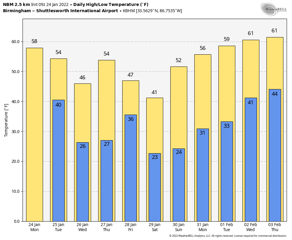 ON THIS DATE IN 1963: A cold wave was in progress across the Deep South. Birmingham dropped to 2 degrees below zero. Other lows included minus 4 at Huntsville, minus 3 at Muscle Shoals, minus 1 at Anniston, 3 at Tuscaloosa, 5 at Montgomery and 8 at Mobile.
ON THIS DATE IN 1967: A tornado outbreak across the central U.S. was the farthest north ever recorded in the winter up to that time. Severe weather occurred across a good portion of southeast and east-central Iowa. Two-inch hail fell at Armstrong, and more than two dozen tornadoes were reported. Five miles north of Fort Madison, one fatality occurred from a tornado, along with six injuries. A tornado causing F4 damage killed three people and injured 216 in St. Louis County, Missouri. Storms also affected parts of northern and central Illinois. One strong tornado in Mason County killed one person and injured three others. Another tornado moved across the Champaign-Urbana metropolitan area, injuring five people.
BEACH FORECAST: Click here to see the AlabamaWx Beach Forecast Center page.
WEATHER BRAINS: You can listen to our weekly 90-minute show any time on your favorite podcast app. This is the show all about weather featuring many familiar voices, including the meteorologists at ABC 33/40.
CONNECT: You can find me on the major social networks:
For more weather news and information from James Spann and his team, visit AlabamaWx.


