James Spann: Mild afternoons ahead for Alabama
James Spann forecasts a spring preview for Alabama from Alabama NewsCenter on Vimeo.
BIG WARM-UP TODAY: Temperatures were between 25 and 32 degrees across most of Alabama early this morning, but with a strong February sun we expect a high in the low 60s in most places this afternoon. The average high for Birmingham on Feb. 9 is 58. Sunny weather continues Thursday and Friday with highs in the 60s; a few spots could touch 70 degrees Friday afternoon for a nice preview of spring.
THE ALABAMA WEEKEND: Look for a partly sunny sky Saturday with a high between 61 and 65 degrees. A cold front will pass through the state Saturday night; moisture will be very limited, but it might squeeze out a sprinkle or flurry in a few spots. Measurable precipitation is not expected. Much colder air returns to the state Sunday. Despite a clearing sky, temperatures won’t get past the mid 40s Sunday afternoon with a brisk north wind.
NEXT WEEK: Temperatures rebound quickly. The high will be in the upper 50s Monday, and then back in the 60s Tuesday and Wednesday. Rain returns Thursday afternoon and Thursday night.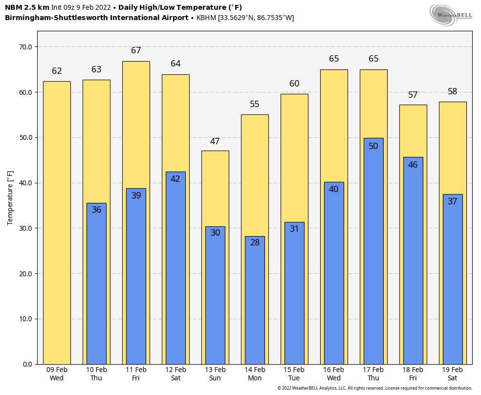 ON THIS DATE IN 1899: One of the most significant cold outbreaks to ever affect the United States occurred in early to mid-February. For Feb. 8-11, the statewide average temperature across Iowa was 14.6 degrees below zero, making it the coldest four-day stretch on record in the state. On Feb. 8, Sioux City experienced its coldest day on record, with a daily average temperature of 24 degrees below zero. On Feb. 11 it reached its second-coldest temperature on record, with a low of minus 31. Overall the coldest readings were obtained on the morning of Feb. 9, when reported low temperatures included minus 21 at Keokuk, minus 23 at Des Moines, minus 33 at New Hampton, minus 35 at Le Mars, minus 38 at Estherville and minus 40 at Sibley. The cold across the middle of the country was so extreme and persistent that ice floes moved down the Mississippi River into the Deep South, emerging into the Gulf of Mexico near New Orleans on Feb. 17. This has happened only one other time: Feb. 13, 1784.
The temperature at Birmingham would drop to minus 10 degrees on Feb. 13, 1899 — still the coldest temperature on record for the city.
ON THIS DATE IN 1994: A devastating ice storm struck Mississippi, Louisiana and extreme northwest Alabama. Freezing rain began falling over northern Mississippi during the early morning and continued until midday on Feb. 10. Ice accumulated 3 to 6 inches thick on exposed objects in the affected area. The weight of the ice downed power lines, trees and tree limbs. Nearly 1 million people were without power after the storm, some for a month. In Alabama, seven counties over the northwest part of the state were devastated. Trees blocked roads, which were already impassable because of the ice glaze. Three- to 5-inch rainfall amounts occurred, resulting in a heavy glaze over the northwest and even causing flooding elsewhere.
ON THIS DATE IN 2011: Up to 4 inches of snow fell across parts of north and west Alabama; in Arkansas, some places saw more than 1 foot.
BEACH FORECAST: Click here to see the AlabamaWx Beach Forecast Center page.
WEATHER BRAINS: You can listen to our weekly 90-minute show any time on your favorite podcast app. This is the show all about weather featuring many familiar voices, including the meteorologists at ABC 33/40.
CONNECT: You can find me on the major social networks:
For more weather news and information from James Spann and his team, visit AlabamaWx.