James Spann: One more mild afternoon for Alabama; much colder air arrives Saturday
James Spann forecasts one more spring-like day for Alabama from Alabama NewsCenter on Vimeo.
ONE MORE SPRING-LIKE DAY: With a good supply of sunshine, temperatures will warm into the 65- to 70-degree range for most Alabama communities this afternoon, about 10 degrees above average for mid-February. Enjoy it, since there will be some major weather changes over the weekend.
A cold front will move through the state Saturday. It will bring clouds, but it should pass through in dry fashion. For most of north and central Alabama, temperatures will fall from the 50s in the morning through the 40s in the afternoon with a brisk north wind. Some communities in the Tennessee Valley could reach the upper 30s by mid to late afternoon.
We project a low between 20 and 25 degrees early Sunday. During the day temperatures won’t get past the mid 40s despite a partly to mostly sunny sky.
NEXT WEEK: The cold snap won’t last long. The weather will be dry Monday through Wednesday with sunny days and a warming trend. We reach the low 50s Monday, low 60s Tuesday and upper 60s Wednesday. A dynamic weather system will bring rain and thunderstorms into the state Thursday and Thursday night. There is still some model disagreement on how the scenario plays out, but it increasingly looks like it will bring potential for strong to severe thunderstorms to Alabama and the Deep South. It’s way too early, of course, for details, but be aware that next Thursday could be a very active weather day. Drier air returns Friday.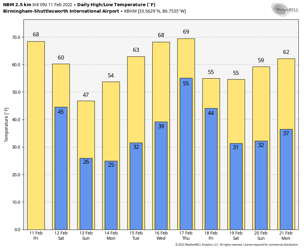 ON THIS DATE IN 1962: A powerful F3 tornado struck Holstebro in Denmark, causing devastating damage. More than 100 houses were severely damaged or destroyed, making this event the most devastating tornado in Denmark’s history. The tornado could have been a low-end F4.
ON THIS DATE IN 1965: An F3 tornado moved through Aliceville in west Alabama. Twelve homes were demolished and another 42 sustained varying degrees of damage. A church, motel, cotton mill and several commercial buildings were heavily damaged. One farm sustained extensive damage. Several injuries occurred in and near Aliceville, but no fatalities were reported.
ON THIS DATE IN 2014: A winter storm brought snow to the northern third of Alabama; some communities north of Birmingham received more than 5 inches. The system would evolve into a major nor’easter and would bring 15 inches of snow to Washington, D.C., and Baltimore.
BEACH FORECAST: Click here to see the AlabamaWx Beach Forecast Center page.
WEATHER BRAINS: You can listen to our weekly 90-minute show any time on your favorite podcast app. This is the show all about weather featuring many familiar voices, including the meteorologists at ABC 33/40.
CONNECT: You can find me on the major social networks:
For more weather news and information from James Spann and his team, visit AlabamaWx.


