James Spann: Warmer days ahead for Alabama; severe storms possible Thursday
SEVERE CLEAR: We have a cloudless sky across Alabama this afternoon with temperatures mostly between 55 and 63 degrees. Tonight will be clear and cold, with a low between 25 and 35 degrees. Temperatures Tuesday will reach the mid 60s with a good supply of sunshine. Wednesday looks dry as well; the sky will be partly sunny with a high not too far from 70 degrees as the warming trend continues.
SEVERE WEATHER THREAT THURSDAY: A dynamic weather system will bring rain and thunderstorms to Alabama Thursday. Some of the storms could be severe by afternoon. Thursday will also be windy, with south gradient winds (not related to thunderstorms) of 15-25 mph, with higher gusts.
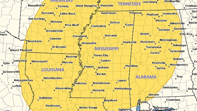
For now it looks like the main window for severe thunderstorms Thursday will come during the afternoon and evening, and higher severe weather probabilities are over the western half of the state back into Mississippi. Storms that form could produce strong winds, hail and a few tornadoes. We will be much more specific on the threat Tuesday as we get within the 60-hour window and can see high-resolution model output. The Storm Prediction Center has defined a severe weather risk for most of Alabama.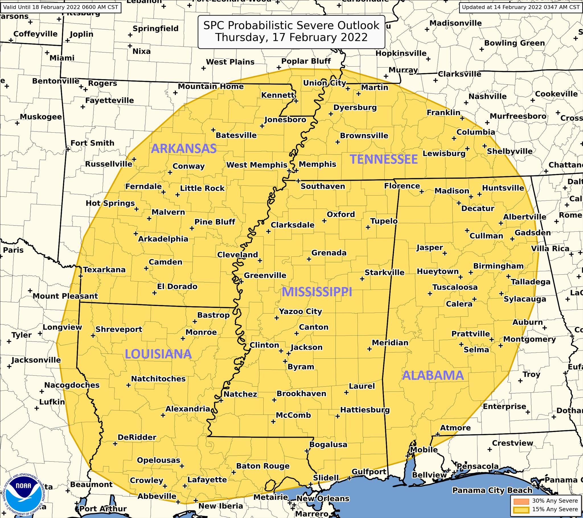 Rain amounts Thursday and Thursday night will likely exceed 1 inch in many places, but flooding is not expected at this time.
FRIDAY AND THE WEEKEND: The sky becomes mostly sunny Friday and the day will be sharply colder, with a high around 50 degrees. Some rain is possible Saturday over far south Alabama, but the rest of the state will be dry with a partly to mostly sunny sky. The high will be in the mid 50s. Sunday will feature a sun-filled sky with a high in the low 60s.
NEXT WEEK: The weather will be dry and mild during the first half of the week. We could see some of the warmest weather so far this year by Wednesday, Feb. 23, with a high in the mid 70s. Showers and storms will return Thursday or Friday.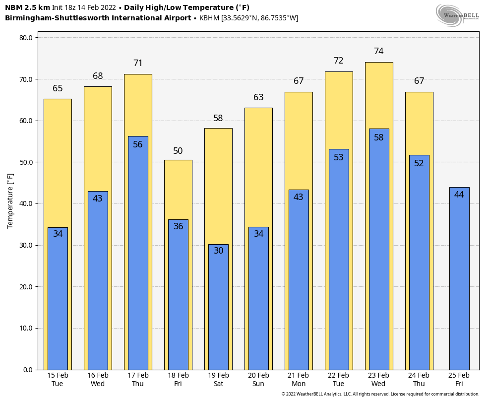 ON THIS DATE IN 1895: The most significant snowfall in the history of Houston, Texas, occurred on Feb. 14-15. The Houston area saw 20 inches of snow.
ON THIS DATE IN 1958: Snow lovers got a special gift as the heaviest snowfall since 1948 blanketed Birmingham with more than 2 inches. Roads in the Magic City quickly became snow-packed and impassable. Roads between Birmingham and Atlanta were especially dangerous. The northwest corner of Alabama was blanketed with 3-6 inches of snow. Six to 8 inches fell in Decatur. At the Birmingham Municipal Airport, a Delta Airlines DC-7 slid off the runway the following morning and buried itself nose deep in slush and mud when the nosewheel broke. None of the 43 passengers was injured.
ON THIS DATE IN 2021: Freezing rain and some snow brought dangerous travel to northwest Alabama. It was the beginning of a five-day stretch of very cold and unsettled weather; there were multiple rounds of snow and wintry precipitation over the northern half of Alabama through Feb. 17.
BEACH FORECAST: Click here to see the AlabamaWx Beach Forecast Center page.
WEATHER BRAINS: You can listen to our weekly 90-minute show any time on your favorite podcast app. This is the show all about weather featuring many familiar voices, including the meteorologists at ABC 33/40.
CONNECT: You can find me on the major social networks:
For more weather news and information from James Spann and his team, visit AlabamaWx.


